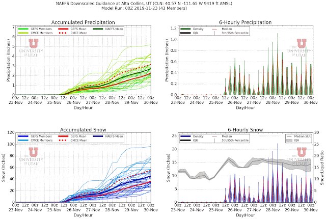
The coming holiday week looks wild as two complex systems affect the weather and are sure to keep meteorologists, skiers, and travelers on their toes.
The first is a surface cold front that is expected to move across northern Utah Monday.
Snow levels will be dropping to the valley floor by Monday afternoon and there is a prolonged period of moist, unstable northwesterly flow in its wake with the potential for orographic (i.e., mountain induced) and lake-effect snow showers.
Through Tuesday morning, the 6Z NAM produced 0.29" of water and 7" of snow at Alta, whereas the GFS was quite excited with 0.81" of water and 17" of snow. Such is the way it is in the "post-frontal" crap shoot given the fickle nature of orographic and lake-effect convection. A look at the SREF shows a mean of about 0.6" of water and 8" of snow, but a spread in the latter from 2.5 to 15 inches, with one member really going off.
My take is that something in the 5-10" range is the most likely scenario for Alta from early Monday morning through Tuesday noon, but that it is worth monitoring forecasts and radar as much will depend on the vigor and placement of the convective snow showers and, if lake effect gets going, where it targets. It's simply not possible to anticipate such details at these lead times.
On Wednesday and Thursday a deep upper-level trough that will amplify and "dig" (i.e., move southward) along the west coast of North America. By 1200 UTC Thursday, the GFS forecasts the trough to be over or off the coast of California with Utah in moist, southerly flow ahead of it.
The corresponding integrated vapor transport diagnostic from the Center for Western Weather and Water Extremes shows very large values of integrated vapor transport moving up the lower Colorado River Basin and into Arizona and southern Utah, with atmospheric river conditions nearly making it to northern Utah.
 |
| Source: Center for Western Weather and Water Extremes |
For the Wasatch, much will depend on the strength, structure, and track of the trough, which cannot be specified precisely at such lead times. Subtracting totals from the Monday-Tuesday storm period, the NAEFS produces anywhere from about 0.7-3" of water and 10 to 55" of snow from 1200 UTC 27 November (5 AM MDT Wednesday) to 0000 UTC 30 Nov (5 PM MST Friday), although the high totals are being produced by Canadian ensemble members that are known for overforecasting. The GEFS members have a range of around 10-30 inches which might be more reasonable.


No comments:
Post a Comment