Wednesday, December 31, 2014

These Park City Temperature Observations Are Amazing

It was a very cold morning on the Wasatch Back.  How about a -24ºF at Kimball Junction, a -13ºF at the base of Park City, and a -17ºF in Thaynes Canyon

24-hour minimum temperatures for period ending at 1636 UTC 31 December 2014. Source: MesoWest.
I did an interview with PCTV this morning and had quite an experience driving over Parley's Canyon just before sunrise, very near the time of minimum temperatures above.  The "always trustworthy" car thermometer showed a temperature fall of about 12ºF from Parleys Summit to the base of the Canyons as I decended into the cold pool resident within Snyderville Basin.

What was most amazing were the variations in temperature at Park City Mountain Resort.  All of the observations in the plot below were collected at 1615 UTC (0915 AM MST).  At that time, skiing down the King Con trail from the top of the King Con chair to the bottom of Silverlode involved a temperature change of 28ºF from 14ºF at the top to -14ºF at the bottom!

Source: Mesowest.
I don't know how many people were on the mountain to experience that sort of insanity, but it must have been a breathtaking run.  

Tuesday, December 30, 2014

Dramatic Temperature Contrasts from Park City to Cottonwoods

One of the most dramatic temperature contrasts that I can remember exists across the central Wasatch today. Observations at sites between 9000 and 10000 feet on the Park City side include -8F at Condor (Canyons), -11 at 9990 (Canyons), -10 at Daybreak (Canyons), -9 at Summit (Park City), and -8F at Ontario (Deer Valley).  A "warm" outlier is Jupiter (Park City), which is at 10,000 ft and at -4F.  More on this in a minute.


Contrast that to Little Cottonwood where Alta-Collins is 0F and Top Cecret is 0F.  In Big Cottonwood, Solitude-Apex, at an elevation of about 9000 feet, its 6ºF.  Even at the top of the Snowbird tram at 11,000 feet its -5F, warmer than the aformentioned sites at 9000 to 10000 feet on the Park City side.

It would be fascinating to do a ski tour across the Park City Ridgeline today as there appears to be a fairly large temperature contrast across it.  Near as I can tell, the top of the coldest air is very near the ridgeline (~10,000 ft), which might explain the warmth of the Jupiter site.  It's cold in the Cottonwoods, but nowhere near as cold (when comparing sites at the same elevation) as on the Park City side.

Why Don't the Cottonwoods Get "Canyon Winds"?

I am reminded this morning of the Norwegian saying, "there's no such thing as bad weather, only inappropriate dress."  Peak gusts this morning of 77 mph in Farmington (Site AP611 @ 7:52 AM), 68 mph in Centerville (CEN @ 7:00 AM), and 60 mph at the University of Utah (WBB @ 4:35 AM).  Temperatures along much of the Wasatch Front are in the low teens or single digits.  There's great skiing to be had in the central Wasatch, but check out the temperatures in the latest MesoWest plot below.  Sub zero at nearly all locations.  The contrast between the east side and west side is most impressive.  Below -10ºF at most mid-mountain observing sites from Deer Valley to the Canyons.  In contrast, it's balmy in Little Cottonwood where temperatures are only in the minus single digits.

Surface winds (barbs) and temperatures (digits) at 15:56 UTC (08:56 AM MST).  Source: MesoWest
One thing you will notice in the plot above is that the winds in the central Wasatch really aren't all that bad.  In fact, it's far windier along the Wasatch Front from Parley's Canyon to Ogden, as can be inferred by the map below in which the digits are now wind gusts.

Surface winds (barbs) and wind gusts (mph, digits) at 15:56 UTC (08:56 AM MST).  Source: MesoWest
It's not all that unusual for the central Wasatch and the Cottonwood Canyons to not be as windy as the northern Wasatch Front during canyon wind events, for a few reasons.  First, the name "canyon winds" is a misnomer.  It gives the false impression that these winds are caused by the funneling of cold air through the canyons, when in reality we are experiencing a downslope windstorm with cold air is spilling across the entire Wasatch Range and causing strong winds from Parleys Canyon northward.

So, a critical component of these downslope wind events is the strength of the easterly flow impinging on the Wasatch and its ability to cross the crest and plunge down the west side, and there are at least two reasons why the Wasatch Mountains north of I-80 take the brunt of these events and not the central Wasatch.

First, there is the influence of the Uinta Mountains to our east.  The Uinta Mountains are a huge barrier and they block and steer the cold air over Wyoming eastward toward the northern Wasatch.    Second, the easterly flow can penetrate more easily across the Wasatch Mountains north of I-80 because they are lower.  It is possible that one of the reasons why Farmington is so windy in these events isn't because of funneling through Farmington Canyon, but the fact that the crest of the Wasatch is a bit lower at the head of Farmington Canyon [perhaps one of our adventurous graduate students can do some super high resolution modeling in the future to investigate this possibility].

The net effect of this is that the Cottownwood Canyons and the area to their west, including Sandy, Draper, and Cotttonwood Heights, are basically in a wake during downslope wind events.  In fact, there is often an eddy near Sandy that we call the Sandy Eddy and it shows up plain as day this morning, although it's centered a bit west of Sandy at the time below.

Surface winds (barbs) and wind gusts (mph, digits) at 15:56 UTC (08:56 AM MST).  Source: MesoWest
In fact, one can see a thin band of stratus cloud forming where the westerly flow on the south side of the Sandy Eddy is being forced upward where it converges with southerly flow nearer the Wasatch Range.

Source: http://205.124.147.71/view/viewer_index.shtml?id=289
If all of this sounds like the kinds of features that you find in a river, you are right!

Addendum @ 10:00 AM: Although the central Wasatch aren't directly affected by the so-called canyons winds, I should note that the easterly flow there will be on the increase today as low pressure moves southward and intensifies.


Monday, December 29, 2014

Nastiness Hits the U of U

Cold air pushed across the Wasatch Mountains this afternoon, initiating the development of easterly downslope winds at the University of Utah.  Temperatures have declined steadily since just after 11 am and you can see the arrival of the airmass from the east in the meteogram below as there is a sharp drop in dewpoint (green line) and increase in easterly winds.  Temperatures are now in the low 20s with winds gusting into to 28 mph.  BRRRR!!!!


It looks like I'll have a long, cold wait for the bus this afternoon!

Return of the Greatest Snow on Earth

Remember a couple of weeks ago when we were skiing on manmade snow at the resorts and searching for anything we could find in the backcountry?  Well those days are officially OVER!

First we had the Base-Building Concrete Deluge thanks to that juicy atmospheric river, followed by the Christmas Miracle Storm.  Then, beginning yesterday, the Return of the Greatest Snow on Earth.

If I'm adding up the automated observations from Alta-Collins correctly, the storm that began yesterday morning and continues today has now laid down 20 inches of snow with an average water content of 4.2%.

The skiing yesterday in the Wasatch backcountry was pretty much as good as it gets.  Low-water content snow usually looks good in pictures, but sometimes doesn't ski as well as you might think, especially if it falls on a relative hard base.  That wasn't the case yesterday as it was falling on settled snow from the Christmas Miracle Storm and it skied fantastic.  A few photos below of one my my Medicare-eligible friends getting the goods.


Alta-Collins is now up to a 77 inch base.  Actually, although this season got off to a slow start, the snowpack is now at or above average at the Snowbird, Mill-D, and Brighton SNOTEL stations.  Further evidence that a bad year in the Cottonwoods is better than a good year in Colorado.  Apologies to those of you on the Park City side.  You're still below average.

Winter weather fun and games looks to continue the next few days.  In addition to today's snow showers, the National Weather Service has already issued a high wind warning for the northern Wasatch Front that is in effect from midnight tonight through 4 AM MST Wednesday, as well as a wind advisory for the Salt Lake Valley and the Cache Valley.  For more information, see http://www.wrh.noaa.gov/slc/.  Some basics on downslope winds can be found in our previous post Downslope Windstorm Anatomy.

University of Utah Atmospheric Sciences/Meteorology Alumni and Friends:

If you are attending the Annual Conference of the American Meteorological Society next week in Phoenix, please come by our Alumni & Friends reception on Tuesday evening.  Info below.

Saturday, December 27, 2014

Twas The Day After Christmas....

This post has been updated to reflect the fact that 1917, not 1916 as originally written, was the warmest December on record. - JS

Here's a meteorological oddity for you.  The day after Christmas was the first this month with a below average minimum temperature at the Salt Lake City airport.  It was also the first day this month with a below average maximum temperature.


So far this month we've been on pace for back-to-back Novembers rather than a November and a December.  Indeed, the average temperature for December so far (40.7ºF) is pretty close to the long-term (30-year) average for November (40ºF).  Incredibly, December 1916 1917 was even warmer, with a month-long average of 41.9ºF.


1916 1917 will be able to sleep well knowing its record is safe.  The next few days will feel very much like December and will pull the average for the this December down considerably.

Friday, December 26, 2014

The Rich Get Richer

The Christmas storm was yet another where the rich (i.e., Little Cottonwood) just keep getting richer.  What kind of a Ponzi scheme is Mother Nature running this year?

As summarized by the National Weather Service, here are the snow totals for the storm so far showing very nicely the contrast from Little Cottonwood to Park City:

Snowbird: 24" (through 6 AM Friday)
Alta-Collins: 19" (4 AM Friday)
Alta UDOT: 15" (3 AM Friday)
Big Cottonwood Spruces: 12" (5 AM Friday)
Solitude: 9" (5 AM Friday)
Brighton Crest: 13" (7 AM Friday)
Canyons, 8800 ft: 12" (7 AM Friday)
Park City Summit: 6" (7 AM Friday)

Some of these numbers are real headscratchers for me.  Only 9" at Solitude and 6" at Park City Summit, but 12" at Canyons and 13" at Brighton?  I wish I planned on skiing today just to walk around the Park City Ridgeline to see what the heck is going on and whether or not these numbers are real or just an artifact of data representativeness. 

If we forget about that noise and instead concentrate on the signal, we see that this was yet another storm where Little Cottonwood cleaned up.  Snowfall totals are highest in Little Cottonwood and drop off as one moves to Big Cottonwood Canyon and then to the Park City side.  Although that's consistent with climatology, we've had several storms this year in which that signal has been highly amplified.  In other words, the contrast between Little Cottonwood and Park City has been larger than we might expect from climatology.  In other words, the rich get richer and the poor get poorer. 

This shows up fairly well in the SNOTEL data.  Through Christmas, Snowbird has a median snowpack snow water equivalent (SWE) of 10.7 inches.  However, it now sits at 14.1 inches, 132% of the median. 

Source: NWS
When we move into Big Cottonwood, the median snowpack SWE at Brighton drops to 8.0 inches, lower than Snowbird.  But while Snowbird is now above its long-term median, Brighton is just below its long-term median at 7.6 inches.  

Source: NWS
Finally, we jump across the Park City Ridgeline to the Thaynes Canyon SNOTEL.  Here the median is 7.8 inches, the lowest of the three sites.  The observed snowpack SWE is 7.0 inches, only 90% of median.  

Source: NWS
 There are no snowpack observations at low elevation on the Park City side, but I suspect this trend amplifies as you head further down the mountain as the snowpack in Park City is typically meager, but is especially so this year.

And here's another interesting thing that I hope someone skiing at Alta today can comment on.  We have an automated snow observing system operating in Albion Basin this year.  It measured about 3" of snow from 3 PM yesterday afternoon through this morning.  The Alta-Collins station got 8" in the same period.

Very interesting stuff. 

Wednesday, December 24, 2014

A Good Omen?

I'm not one for superstition and wives' tales, but I did see a good "snow sun" with a faint halo while skinny skiing at North Fork Park this morning.  


Surely that's a good omen for our Christmas Miracle storm?  The NWS has hoisted the Winter Storm Warning for the Wasatch Front and Mountains and is calling for 3-6 inches on the valley floors, 5-10 inches on the benches, and 10-20 inches in the mountains (see http://www.wrh.noaa.gov/slc/ for specifics and updates).  Hopefully tomorrow things will look like this.

Photo: Tyler Cruickshank.
Merry Christmas from the Wasatch Weather Weenies!

Tuesday, December 23, 2014

Northern Utah's Christmas Miracle

After considerable negotiations, I've been able to convince Mother Nature to allow the Snow Miser to bring snow to Salt Lake City for Christmas.

Source: RankinBass
Snow Miser's magic is already apparent in the latest model forecasts (surely you've heard about them already).  Below is the latest NAM bringing the Christmas miracle front across northern Utah late on Christmas eve, just in time for Santa to have a very-late-night landing on snowy roofs across the valley.  Don't let your kids get up too early.


Oh, and there's a special treat for the skiers.  This is a real Utah storm that will bring a right-side-up snowfall for the entire Wasatch.  The Cottonwoods will probably come out on top as usual, especially in the later post-frontal storm stages, but even you poor, deprived souls on the Park City side should be happy with your gifts on Christmas Day.  No coal for you.  Santa has removed you from the Naughty List!

And I've arranged for Santa to give a special treat for the Nordic skiers out there.  Your environmentally sensitive ways and cardiovascular fitness have placed you right at the top of the nice list.  Santa is going to make sure this storm is cold enough to produce snow at Mountain Dell, Mill Creek Canyon, North Fork Park, and Soldier Hollow!

Now boys and girls, if you are really good, Santa has told me that he may provide some more cold snow later in the holiday week.  Don't screw this up by misbehaving.  No skiing above other skiers in the backcountry.  No putting in obscenely steep skin tracks.  No cutting in lift lines.  And, most importantly, no farting on the tram!

Monday, December 22, 2014

The Big Blow

Near as I can tell, nearly all the Wasatch Resorts are struggling today.  Many lifts are closed either due to wind or avalanche danger.  The Utah Avalanche Center reports some tree blowdown.  Things will be better tomorrow and the snow will still be there.

We're fortunate that many of the ski areas send us observations from their weather stations.  This allows us to put events like this into perspective and it helps a lot with forecasting.  The highest reported wind gust today at the top of Snowbird was 105 mph at 9 am.


That's out there in outlier territory.  My friends at MesoWest tell me that it's the highest gust they can find in their archives for Hidden Peak, although they note that there are lots of periods when we don't get data and their record goes back only to 1997.  utahweather.org reports that Hidden Peak had a 124 mph gust on November 8, 1986.  Thus, it can blow harder, but 105 is quite a gust for this location.

Mother Nature Goes Into Beast Mode

There was a moment yesterday morning when snow levels were still near 7000 feet, snow was falling with a water content of 10% or so, and pictures were rolling in on my twitter feed showing some decent turns that I thought perhaps this storm won't be as bad as I thought.

And then Mother Nature invoked Marshawn Lynch and went into Beast Mode.


Ridge top winds started to gust over 90 miles per hour (see above), mid-elevation temperatures climbed, snow levels rose, and the snow or whatever the hell was falling at that point became thicker than Cascade Concrete.  I would call it the Nightmare Before Christmas except for one thing.

I LIVE FOR THIS STUFF.

Wow, what a storm.  We are currently up to a storm total of almost 3.5 inches of water at both Alta-Collins and our new observing system in upper Albion Basin.  Precipitation observations in snow are notoriously bad when it is windy, so frankly I find it quite remarkable how close these two are and that they seem fairly reasonable relative to water contents reported by the Utah Avalanche Center.


During one period overnight, Alta had 6 inches of snow, which doesn't sound like much, but it had a 20% water content.  That's about as thick as it gets and it will be a good base builder.  However, temperatures are now falling, so we'll see a transition to lighter snow today and snow levels are now approaching bench level.

There were some big water numbers at some other locations in the Wasatch.  Ben Lomond Peak, for example, is now over 4 inches.  I suspect snowfall in that area, at least below 8000 feet and possibly higher, was reduced somewhat by the high snow levels late yesterday and in the early overnight hours.

I noticed a few resorts are reporting delayed openings.  Mother Nature is still in Beast Mode.  Check before you go.

Looking for a Stocking Stuffer?  
Demand for Secrets of the Greatest Snow on Earth has been amazing!  If you are looking for a last-minute stocking stuffer, Barnes and Noble currently has them in stock (as of Monday morning) at their Sugarhouse and Gateway Crossing (Bountiful) stores, but call ahead and put it on reserve to be sure.  Weller Book Works had stock the last I checked, but call ahead.  Kings English had a new shipment coming, so similarly, call ahead.  There's also Amazon and direct from Utah State Press, although delivery by Christmas might cost you a pretty penny.

Sunday, December 21, 2014

Oooh Baby, Talk Dirty to Me!

As anticipated for the last few days, atmospheric river conditions have pushed into northern Utah and are bringing widespread precipitation (valley rain, mountain snow) to the northern half of the state.

The large scale pattern is illustrated nicely by the 12-hour GFS forecast valid at 1200 UTC (0600 MST) this morning (sorry to use a forecast, but I have a narrow window to write this).  An upper-level ridge is parked off the U.S. West Coast with strong water vapor transport (color scale) extending inland into Utah.

Source: NWS
If you want to get strong water vapor transport into northern Utah, this is one of two ideal scenarios, the other being an atmospheric river that extends across Baja California and over the lower Colorado River Valley.  In both instances, the atmospheric river avoids interaction with the high, broad Sierra Nevada.

Patterns like this are often called dirty ridges by meteorologists since clouds and precipitation extend well downstream of the ridge axis.  Well oooh baby, talk dirty to me as I like the precipitation numbers coming in from the central Wasatch in these early storm stages.

From 3 to 8 am this morning, Alta-Collins has picked up 6 inches of snow with 0.53 inches of water. Our "Top Cecret" observing site in Albion Basin is at 4 inches with .39 inches of water.  It's mild by climatological standards, but temperatures this morning are at or below freezing at the central Wasatch resorts, including those on the Park City side.  Thus, we're getting some snow at mid elevations so far and we'll take all we can get.

Source: MesoWest
However, temperatures and snow levels will rise today, the latter maxing out near 8000 feet, before falling overnight.  Bring the gore-tex or the trash bag if you are skiing or boarding today as even the upper-elevation snow is likely to be wet and heavy.  The higher you can get the better.  Forecasts are still on track for the 2-3 inch storm-water totals through Monday afternoon in the upper Cottonwoods, which should significantly improve ski conditions for the coming holiday.  Backcountry travelers be aware that the Utah Avalanche Center has issued an avalanche warning for all the mountains of northern Utah.  This is a lot of weight to add to a cranky snowpack, and they are even concerned about rain on snow in the lower elevations.  Get the latest advisory here.

Saturday, December 20, 2014

Mother Nature's Abuse of Snowflakes Today and Tomorrow

Although we all love beautiful, pristine snowflakes, the reality is that most snowflakes in winter storms have been abused in some way, shape, or form.

If you were out today, you probably saw a few pristine snowflakes, but also plenty of defective ones.  Here are a few examples to illustrate the flake diversity.  All of these were taken with my el cheapo point-and-click camera over a period of just a few minutes.  

First we have two somewhat pristine stellar dendrites.  These are Mother Nature's favorite sons as they have experienced little riming and have landed on my thigh without mechanical fracturing.  


The next is lightly rimed.  You can tell it was a 6 armed snowflake at one time, but as the flake fell, it collected supercooled cloud droplets (i.e., cloud droplets that are colder than 0ºC but haven't yet frozen), which froze on contact and coated the flake to some degree.  


Here's another that's moderately rimed.  The six arms are barely distinguishable.


There are a number of ways that Mother Nature tortures snowflakes.  One is riming, as illustrated above.  Another is by smashing them together.  Riming typically increases with temperature, although there are other factors that can contribute, and the smashing and mechanical fracturing of snowflakes typically increases with wind speed and turbulence.  

Between today and tomorrow we will see a massive escalation of snowflake abuse in the Wasatch Mountains as temperatures and winds increase.  At upper elevations, there's going to be lots of defective snowflakes tomorrow (at the lower elevations, you're going to find rain).  Listen carefully and you might hear their cries of pain and agony.   

Both riming and mechanical fracturing increase the density/water content of snow.  You're not going to find the Greatest Snow on Earth in the Wasatch tomorrow.  Instead, we're going to see Cascade Concrete.  This is going to be a storm that produces a lot of water, but because the snow is so dense, snow totals won't be eye popping.  For example, in upper Little Cottonwood the NWS is calling for 2–3 inches of storm water through 4 PM Monday (including what fell today), but only 18–24" of snow.  

That high density snow, however, is just what we need for base building in the upper elevations.  Unfortunately, snow levels tomorrow will be fairly high tomorrow and may flirt with 8000 feet at times, so the lower elevations won't be as fortunate.  

Friday, December 19, 2014

Expand Your Weather and Climate Education

The semester is over, Google Calendar tells me I have no events scheduled for today, and therefore I have some "personal matters" to attend to today (wink wink).  Thus I am providing an educational video for you that should help you to understand the highly variable nature of wintertime weather in Utah.


I often tell my students that everything you need to know about weather and climate is in The Year Without a Santa Claus, from which that video is excerpted.  Yup, you get a diverse meteorological education at the University of Utah. 

Models continue to look on track for a Sunday–Monday storm as discussed in the previous post.  Keep your fingers crossed.

Thursday, December 18, 2014

Things Are Brewing in the Pacific

Over the past couple of days, the medium-range forecast models have been hinting at the potential for an inland penetrating atmospheric river (AR) and a significant precipitation event for the mountains of northern Utah beginning on Sunday.

We begin yesterday in the western Pacific where strong moisture convergence along a cold front east of Japan contributed to the formation of the AR, which was characterized by high integrated water vapor values (contours, with warmer colors indicating higher values).


Those of you longing for powder might take a gander at the satellite image above and see numerous cloud bands extending from the coast of Asia to Japan where it has been puking powder for the better part of the past week or two.  My facebook feed from Hakuba has simultaneously invoked joy and jealousy as it's been day after day of photos like the ones below.

Source: https://www.facebook.com/hakuba1
But I digress.  The loop below shows the observed and forecast IR satellite image and integrated water vapor through 1200 UTC 21 December.  Note how the AR moves across the Pacific and then becomes directed toward the Pacific Northwest.


Although the images above present integrated water vapor, a better diagnostic for tracking ARs into the western interior is integrated water vapor transport, which measures the flow of water vapor over a given location and correlates better with mountain precipitation during the cool season.  The mean forecast of integrated water vapor transport by all members of the Global Ensemble Forecast System (GEFS, top panel) and by the GFS (bottom panel) for 1200 UTC Monday 22 December show the AR spilling over the long-wave ridge centered off the coast of California and then extending east southeastward across southern Idaho, northern Utah and western Wyoming, and Western Colorado.

Source: NWS
This is an ideal track for moisture penetration into the interior western United States because the AR moves across the lower, narrower Cascade Mountains of Oregon and over Snake River Plain.  Thus, the loss of water vapor to mountain precipitation is smaller than when an AR intersects higher and wider mountain barriers like the southern Sierra Nevada.

The GFS accumulated precipitation forecast through 1200 UTC (0600 MST) Tuesday shows precipitation maxima over the Wasatch and mountains of western Wyoming, as well as the western Colorado Rockies.

Source: NWS
Over the Wasatch, most of this precipitation falls beginning early Sunday.  As a result, I need to point out that we're looking at a 72-126 hour forecast and thus there are important issues to consider with regards to forecast confidence.  First, much depends on the position of the AR.  A shift to the north would be bad.  A shift to the south would be good (for central Wasatch snow).

As a result, when we look at an ensemble of our experimental downscaled forecasts from the North American Ensemble Forecast System for Alta-Collins we see some that produce a great deal of precipitation (direct AR hit) and others that are fairly dry (miss to the north).  We think that our downscaling is overforecasting, so don't take the absolute values too literally.   They key point is that this has the potential to be a significant event, but there remains some uncertainty.


The second concern is the temperatures.  This will be a warm event.  The 700-mb temperatures on Sunday and Monday are currently forecast to be between -2ºC and 0ºC.   That's very warm and it will likely yield wet, high-density snow.  That's good for the upper elevations where we need a good pasting for base, but this could be another lower elevation rain event.  It's too soon to speculate on exactly where snow levels will be.

So, the bottom line is that we have some potential for a significant mountain precipitation event beginning on Sunday.  The gory details depend on how things come together the next few days.  Keep your fingers crossed and stay tuned to the forecast.

Events and Announcements:

I'll be talking about Secrets of the Greatest Snow on Earth, snow, weather, and who knows what else today (Thursday Dec 18) on KUER's RadioWest show at 11 am.  Tune in to 90.1 FM or catch the live stream here

Wednesday, December 17, 2014

When No Snow Is a Good Thing

Smog over the Salt Lake Valley this morning as viewed from the Avenues
So far this year, the air quality in the Salt Lake Valley has been far better than the previous two years.  Although it is on the upper east bench and thus is a cleaner observing site compared to those on the valley floor, air quality sensors at our mountain meteorology lab near Red Butte Canyon show that PM2.5 concentrations over the past month have only briefly exceeded 30 ug/m3.

Source: MesoWest
Differences in the severity, frequency, and persistence of poor cool-season air quality episodes over the Salt Lake Valley aren't the result of changes in emissions, but instead meteorology.  Although we've had another dry start to the inversion season this year, we haven't had a big cold intrusion since mid November to establish a cold pool over the valley.  In addition, we've had enough weak systems come through to stir things up from time to time.  But, perhaps most importantly, we haven't had any significant snow cover on the valley floor.  Yes, I admit it.  This is one time when no snow is a good thing.

Compared to a snow-free land surface, snow has two major influences on the exchange of energy between the Earth's surface and the atmosphere.  First, it reflects more sunlight back to space.  Second, it has a very low thermal conductivity, so it effectively insulates the atmosphere from the ground (or alternatively from houses or buildings if you are in a residential or commercial area).  Collectively, these two effects result in stronger and more persistent inversions than would occur during non snow-covered periods.  

When the right conditions exist, we can still get inversions without valley snow cover, even some strong ones.  However, the lack of snow cover has probably helped some with the air quality so far this winter.  

Events and Announcements:

I'll be talking about Secrets of the Greatest Snow on Earth, snow, weather, and who knows what else tomorrow (Thursday Dec 18) on KUER's RadioWest show at 11 am.  Tune in to 90.1 FM or catch the live stream here.  

Tuesday, December 16, 2014

Secrets Gets Around

US Air Force Colonel Steve DeSordi made my day today when he sent me a photo of him reading Secrets of the Greatest Snow on Earth at the Qatari Minister of Defense's beach house on the Persian Gulf.


Monday, December 15, 2014

Looking Back at the World 24-Hour Snowfall Record

The world 24-hour snowfall record is 76 inches at Silver Lake, Colorado on April 14–15, 1921.  I've always been interested in this record for a few reasons.  One is that it's HUGE.  Another is that if I had a time machine, it would be one of the events I would surely target to experience, both to see the crazy snowfall records, but also to see if the record truly "holds water."

Silver Lake is just east of the Continental Divide and due west of Boulder, Colorado, at an elevation of a bit over 10,000 feet (see the P thumbnail below).


As is the case with many old snowfall records, the Silver Lake record has its quirks.  The veracity of the record was first examined in a paper by J. L. H. Paulhus of the U.S. Weather Bureau (now the National Weather Service) that appeared in Monthly Weather Review in 1953.  It turns out that the 24-hour total of 76 inches is an estimate based on the proration of a 27.5 hour accumulation of 87 inches.

Source Paulhus (1953)
The record was further examined by a team of meteorologists assembled by the National Weather Service to evaluate the potential of a new record of 77 inches on the Tug Hill Plateau in 1997 (report available here).  As summarized in their report:
"The Silver Lake observer recorded 6 feet of snow on the ground at the 6:00 p.m.
observation on April 14, of which 5.5 feet were aged winter snowpack already compacted. The next depth of snow-on-ground observation was taken at 6:00 p.m. on the 16th, 19 hours after the snow had ended. Thirteen feet of snow were reported to be on the ground at that time, which settled to a depth of 11 feet by the 19th. This increase in snow depth is exceptionally great and nearly equals the amount of snowfall reported for the 27.5 hour period. This is strong evidence for a truly remarkable snow event. Unfortunately, it is not possible to determine if a representative site for measuring snow depth had been selected by the observer."
In examining surrounding snowfall observations, it is clear that the area observed heavy snowfall during this period.  The team noted, for example, that several feet of snow with large amounts of water fell over the region.  On the other hand, they ultimately concluded:
"The lack of a specific 24-hour measurement of snowfall during the storm, suspicions of a less-than-ideal exposure for the Silver Lake measurements, and a tendency for larger monthly and seasonal snowfall totals for the Silver Lake station in comparison with nearby stations during the 3-year period from June 1920-June 1923, when one particular observer was responsible for Silver Lake observations, all cast some doubt on the published 76-inch, 24-hour total."
Nevertheless, they go on to accept 76 inches as a reasonable estimate of the 24-hour snowfall (in case you are wondering, the 77" total for the Tug Hill was not accepted because it was based on six observations in 24 hours instead of a maximum of four as is generally recommended).

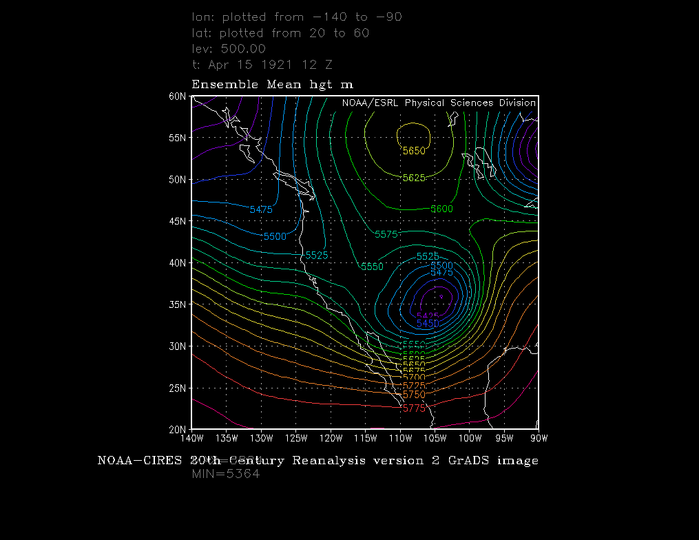
Thanks to modern data assimilation and numerical modeling wizardry, we can now get a look at the synoptic setup for the Silver Lake record.  Shown below are the 850-mb and 500-mb analyses for 1200 UTC 15 April 1921 from the 20th Century Reanlysis (20CR).  It shows a well-known pattern for heavy precipitation along the eastern slopes of the Colorado Rockies (e.g., Poulos et al. 2002) with a vertically stacked cyclone centered over eastern New Mexico, high pressure over the northern plains, and deep geostrophic easterly flow extending from the surface to well above the crest of the Continental Divide.

Source: NOAA/ESRL 
Source: NOAA/ESRL
In all likelihood, the Silver Lake event was exceptional.  Whether or not it produced 76 inches remains forever lost in history.  This is the case for nearly all older snow records (including the possibility of 78 inches in 24 hours in Alaska recently reviewed by Christopher Burt).  We really don't know what the 24-hour snowfall record is, although it's probably north of 60 inches and south of 80.  Get that time machine warmed up.

Sunday, December 14, 2014

The Endangered Stellar Dendrite Returns

It was great to see the return today of the unofficial state bird of Utah, the stellar dendrite.


They were plentiful on the landscape.


Looks like a storm total of 11 inches now on the Alta–Collins stake.  However, we need more.


Then again, as Dave Hanscom and Alexis Kelner say in Wasatch Tours Volume 2, true cross-country touring is, after all, a character developing and strengthening form of recreation.

Saturday, December 13, 2014

A Slow Snow Start Across the West

It's been a while since I took a broader look at the state of the snow across the west so I thought I'd have a look today.

Based on snowpack snow-water equivalent, things are fairly grim across much of the west including Colorado, Utah, Nevada, Oregon, and Washington.  The northwest interior fares a bit better, with some mountain basins sitting closer to average.  Relative to average, the healthiest snowpacks are in western Wyoming.  The "beefiest" snowpack relative to climatology is in the Albion Mountains of southeast Idaho.  Pomerelle ski area is there, but even at 145% of average, they are only reporting a 27-33" base.

Source NRCS
Another perspective is provided by automated snow-depth sensors.  If you are looking for 3 feet or greater, look for upright green, blue, or purple triangles (see scale at lower left).  If you look hard, you can find a few of the green ones (37–48 inches) in the North Cascades and Northern Rockies.  There looks to be one in the Park Range of Colorado too.  

Source NRCS
There are no SNOTELs in the southern Sierra, but Mammoth is reporting a 24-36 inch base this morning.

Things are most grim in the Pacific Northwest.  Here's a shot from Snoqualmie Pass this morning.

Source: http://www.summit-at-snoqualmie.com/
Near as I can tell, none of the Washington ski areas are open, including Mt. Baker.  Their most recent report is below and is one of the gnarliest I think I've seen.  10 inches of rain, 104 mph winds, and "on the positive side...we haven't lost any ski runs or had any damage any where in the area."  

Source: http://www.mtbaker.us/
Meanwhile, we can be grateful for the 4" of snow that fell overnight at Alta and whatever we get from the lingering snow showers today.  

Friday, December 12, 2014

Let's Try This Again!

Yesterday was one of the more frustrating days I can remember as a meteorologist.  Temperatures at the Salt Lake Airport simply refused to budge.  The meteogram below shows how the day went.  We were 55º before 11 am, and still could only top out at 57ºF.  Granted, that's still 19ºF above average, but it fell well short of my expectations.

Source: MesoWest
The development of fairly thick cloud cover didn't help any, but I'm still amazed that the strong flow couldn't scour out the shallow stable layer and lens of cool air that was camped over the Salt Lake Valley.  You can see both the strong flow and the shallow stable layer in the afternoon sounding below.  If we had scoured out that layer, we would have likely had a record high for the day.

Source: SPC
So, let's do this again today.  Once again we have everything in place.  Strong winds aloft (even stronger than yesterday is likely), a warm airmass, and an existing maximum temperature record for the day of 61ºF.  In addition, we're already 50ºF (warmer than yesterday, at least I got that right) and we have a well developed dry slot moving over us to give us at least a few hours of sun.


Therefore, I'm going to stick to my guns and say we will tie or break the record for today and we will see temperatures in the low 60s.  I'm stubborn if anything.

Forecasts for tonight and Saturday continue to suggest a modest snow event in the central Wasatch as the tremendous storm system that has been clobbering California has largely been shredded by the Sierra Nevada (as can be inferred by the image above), leaving us just a few scraps.  The models call for an upper-level front to pass tonight, giving us a burst of mountain snowfall and valley showers, and then a surface-based front to pass during the day tomorrow.  Total snowfall in the central Wasatch will largely depend on how productive these two features can be, especially the latter.  I'll stick with something in the 4-8 inch range for total snowfall through 5 PM Saturday at Alta.

Events and Announcements:

I've joined the dark side and you can now follow me on Twitter: @ProfessorPowder.  Tip of the hat to Backcountry Magazine for the clever handle.

I'll be giving a talk on my new book Secrets of the Greatest Snow on Earth at the Alta Lodge tonight at 5:30 PM, with a book signing to follow.  King's English will be there selling books if you need to pick one up.