Silver Lake is just east of the Continental Divide and due west of Boulder, Colorado, at an elevation of a bit over 10,000 feet (see the P thumbnail below).
As is the case with many old snowfall records, the Silver Lake record has its quirks. The veracity of the record was first examined in a paper by J. L. H. Paulhus of the U.S. Weather Bureau (now the National Weather Service) that appeared in Monthly Weather Review in 1953. It turns out that the 24-hour total of 76 inches is an estimate based on the proration of a 27.5 hour accumulation of 87 inches.
 |
| Source Paulhus (1953) |
"The Silver Lake observer recorded 6 feet of snow on the ground at the 6:00 p.m.In examining surrounding snowfall observations, it is clear that the area observed heavy snowfall during this period. The team noted, for example, that several feet of snow with large amounts of water fell over the region. On the other hand, they ultimately concluded:
observation on April 14, of which 5.5 feet were aged winter snowpack already compacted. The next depth of snow-on-ground observation was taken at 6:00 p.m. on the 16th, 19 hours after the snow had ended. Thirteen feet of snow were reported to be on the ground at that time, which settled to a depth of 11 feet by the 19th. This increase in snow depth is exceptionally great and nearly equals the amount of snowfall reported for the 27.5 hour period. This is strong evidence for a truly remarkable snow event. Unfortunately, it is not possible to determine if a representative site for measuring snow depth had been selected by the observer."
"The lack of a specific 24-hour measurement of snowfall during the storm, suspicions of a less-than-ideal exposure for the Silver Lake measurements, and a tendency for larger monthly and seasonal snowfall totals for the Silver Lake station in comparison with nearby stations during the 3-year period from June 1920-June 1923, when one particular observer was responsible for Silver Lake observations, all cast some doubt on the published 76-inch, 24-hour total."Nevertheless, they go on to accept 76 inches as a reasonable estimate of the 24-hour snowfall (in case you are wondering, the 77" total for the Tug Hill was not accepted because it was based on six observations in 24 hours instead of a maximum of four as is generally recommended).
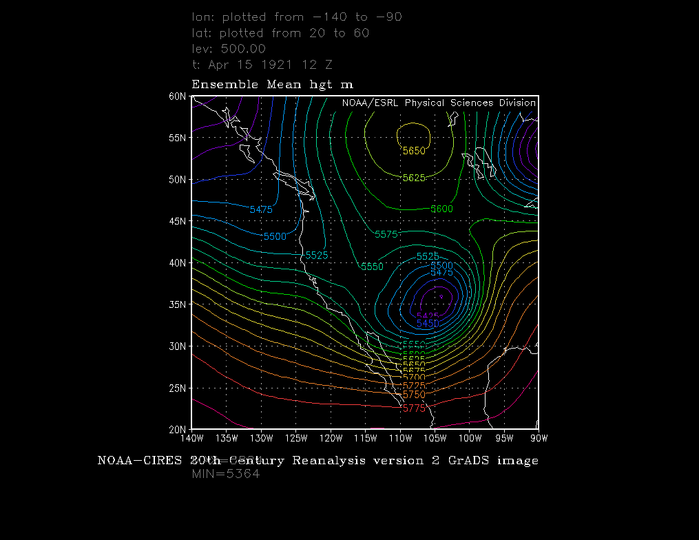
Thanks to modern data assimilation and numerical modeling wizardry, we can now get a look at the synoptic setup for the Silver Lake record. Shown below are the 850-mb and 500-mb analyses for 1200 UTC 15 April 1921 from the 20th Century Reanlysis (20CR). It shows a well-known pattern for heavy precipitation along the eastern slopes of the Colorado Rockies (e.g., Poulos et al. 2002) with a vertically stacked cyclone centered over eastern New Mexico, high pressure over the northern plains, and deep geostrophic easterly flow extending from the surface to well above the crest of the Continental Divide.
 |
| Source: NOAA/ESRL |
 |
| Source: NOAA/ESRL |


Any thoughts on the validity of the event at Mile 47 camp in Alaska?
ReplyDeleteI think the issues there are similar to other older snowfall records. Ultimately, there are some question marks.
ReplyDeleteWe'd like to assume that all observations are correct, but that's simply not the case. All observations have issues with regards to accuracy and representativeness, and snowfall observations are amongst the worst of the lot. Unfortunately, we don't have sufficient details from these historical events to figure out just how good the observations are.