Tuesday, November 15, 2016

Last Day of Summer Today, Winter Tomorrow Night

I guess we can call today the unofficial last day of summer.  I was going to put summer in quotes, but it is not as ridiculous as it sounds.

This morning's sounding had a 700-mb temperature of 6.8ºC, which represents the average for mid September, technically not meteorological summer, but within astronomical summer.

Source: SPC
It should be noted, however, that there have been higher 700-mb temperatures observed at the airport in November, including 8.7ºC on Nov 19 (LST).  Model forecasts for later this afternoon top out at 7.6ºC (NAM) and 6.9ºC, so we're not in completely rarified air yet.

Nevertheless, the day is going to be splendid, with the maximum temperature constrained only by how much we mix out the strong valley inversion that was present this morning (see above).  At 11 am, we were at 63ºF at the airport and 65ºF at the University of Utah.  Bench locations will likely eclipse 70ºF today.  The maximum at the airport is, however, quite tricky to forecast as much depend on whether or not the southerlies can scour out the cold air along the valley floor and keep the lake breeze at bay.  

At 11:28, the strong influence of the Great Salt Lake was apparent.  Over the northern Tooele Valley, where the lake breeze was in f ull force, temperatures were only in the 50s, compared to the 60s near Tooele and 64 at Stockton.  Over the Salt Lake Valley, the lake influence on temperature is weaker, but light northerly flow was evident near the Kennecott Tailings pile.  


Given that we got to 70 yesterday, and the southerly flow is stronger today, I'm going to live dangerously and say we will break the daily record today with a high of 71ºF.  If the southerlies really get going, it could get quite a bit warmer than that, but I think it will be difficult for the cold air to completely mix out.  Note that the lake breeze could usher in some cooler air, especially near the airport, later today.  

Getting to the important stuff, the models have converged on a solution similar to that advertised by the ECMWF and NAM yesterday.  As such, it is likely that the cold front will push into the Salt Lake Valley tomorrow afternoon, probably after 2 PM.  Right now, the models call for a dry frontal passage, with precipitation moving in during the evening when snow levels will drop rapidly, falling to near the valley floor by 9 PM or so.  By Thursday morning, expect temperatures in the low 30s.

Snow?  Yes, I think everybody will see some and I expect snow on cold surfaces when I awake Thursday morning.  Amount forecasts remain dicey.  The models typically are best for precipitation generated by cold fronts and it looks like an inch or two is possible on the benches from that.  Where things get dicey is following the frontal passage and whether or not the post-frontal environment will be sufficiently unstable to get going with or without assistance from the lake.  We'll take a look at that tomorrow, although you should expect continued hand waving.  

For the mountains, I've consistently said that there are a wide range of possibilities and I remain uncertain about the size of this storm except to note that the odds of a major dump in excess of 18" are lower today than yesterday (but not zero).  Water equivalents being produced by the models today are fairly paltry, but low snow density may help generate larger snowfall accumulations.  My take is that 5-10" is probably the most likely range for Alta, but I would not be surprised if we came in below or above that range.  

Monday, November 14, 2016

Thursday Will Bring a Shock to the System

It has been a remarkable fall across the entire Northern Hemisphere.  The large-scale upper-level pattern has been totally locked in.  As shown by the mean (left hand side) and departure from average (a.k.a. anomaly, right hand side) 500-mb analyses below, the pattern has featured anomalous troughing over the northeast Pacific, ridging over North America, and ridging over the North Atlantic and Arctic.

Source: NOAA/ESRL
That large-scale pattern remains in force today, leading to well above average temperatures in the Arctic, where sea-ice coverage is at a record low and above average temperatures across much of North America.  In contrast, ,below average temperatures exist across much of Eurasia, especially Siberia. 


Source: ClimateReanalyzer.org

This weekend, I watched some of the World Cup skiing races from Levi, Finland and it was like viewing another planet as it sure looked like winter there, whereas here in Utah I threw on shorts and a t-shirt to mountain bike.  

In fact, the past month (13 October - 13 November) rates as the 2nd warmest on record at the Salt Lake City International Airport, with an average temperature of 55.6ºF.  Just 0.1ºF ahead of it is the comparable period from 1927.  

Source: NOAA Regional Climate Centers
However, dramatic and abrupt change is coming.  The GFS 500-mb and 6-h accumulated precipitation forecast below shows a deep upper-level trough centered over Utah at 1800 UTC (1100 MST) Thursday.  WHOOPIE!!!


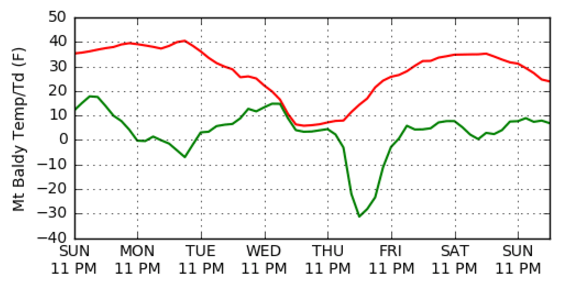
The transition from Tuesday through Thursday is going to be enormous.  The GFS calls for a 35ºF temperature swing at 11,000 feet.  


Basically, we are looking at a transition from temperatures that may reach 70ºF at the airport tomorrow (Tuesday) to snow on the valley floor possibly as early as Wednesday night and Thursday.  

There is a great deal of spread amongst the models in terms of the how everything will go down Wednesday and Thursday.  The 0600 UTC GFS favors an amplified trough, which leads to a later frontal passage and later precipitation, as well as a longer period of precipitation following frontal passage.  In contrast, the 0000 UTC ECMWF and 1200 UTC NAM (which just came in) favor a weaker trough, which leads to an earlier frontal passage on Wednesday and precipitation moving in as early as late Wednesday afternoon or Wednesday evening.  

In either event, Thursday is going to bring a shock to the system.  Given the spread in forecasts, it's too soon to discuss with any confidence the details of how this storm will evolve, but prudence dictates that you take care of your car and commute winterization needs by Wednesday afternoon. 

Should you get the skis waxed?  Well, I still see a wide range of outcomes given the diversity of model forecasts in the various ensembles, with perhaps a storm total of 6 inches being on the low end of possibilities and something like 30" at the high end if everything were to come together wonderfully.  

Below are our downscaled snow estimates from the North American Ensemble Forecast System and these show the mean of all ensemble members being around 18" for upper Little Cottonwood with about a 90% chance of 6 inches or more, 70% chance of 12 inches or more, and 20% chance of 24 inches or more.  
We've made some changes to this algorithm over the summer and it's not as "jacked up" as it has been in the past.  My take, however, is that if one were to add the European ensemble to the mix, these numbers would shift downward a bit.  Keep expectations low and hope for the bigger solutions to verify.

Saturday, November 12, 2016

Rocky Mountain Power Is Scared


During the past week, Rocky Mountain Power announced that they are recommending a three-part monthly rate increase for future residential net-metered solar customers, including a $15 fixed charge, a $9.02 per kilowatt for peak period demand, and 3.81 cents per killowatt-hour for the amount of energy used.  While not applying to existing home solar produces, this would greatly disincentivize future installations.

The argument for doing this is based on a study conducted by Rocky Mountain Power claiming that rooftop solar customers are underpaying their actual cost of service by $400 per year.  Subsequently, Rocky Mountain Power's external communications director Paul Murphy argued in an op-ed piece in today's Salt Lake Tribune that Rocky Mountain Power is committed to solar and customer fairness, but that the cost noted above represents a substantial subsidy.

If Rocky Mountain Power is committed to solar (and I doubt that they are), this action clearly shows that they want large-scale solar farms rather than residential solar.  As a regulated monopoly, that makes perfect sense.  They want to deliver all the power that we use, rather than a fraction.  Residential solar production is a major threat to their revenue stream and that would really suck for them.

It is also rich that Rocky Mountain Power is so concerned about this particular subsidy.  The International Energy Agency estimates that annual fossil-fuel subsidies amount to approximately a half-trillion dollars globally.  Such subsidies do not include the externalized costs arising from air pollution, climate change, and other effects from fossil fuel combustion.  Rocky Mountain Power gets a free ride on all those externalized costs.  In a way, we as electrical consumers get a free ride too on our electrical bills, although we pay the price in other ways.

They also don't seem concerned about federal subsidies for rural electricity production or federal loan and loan guarantees.  They aren't worried about the uneven costs of producing and providing electricity to rural and urban areas.  Clearly some are subsidized and some are paying more than their share (NOTE: I am a firm supporter of ensuring that all American residence have reasonable access to electricity at reasonable costs and that we each bear the costs of ensuring that).

So, let's get real.  If residential solar is as costly as they claim (and that should be confirmed by an independent audit rather than letting the fox guard the henhouse), Rocky Mountain Power is basically choosing to go after it simply because the last thing that they would want to see is a stampede to a paradigm where we the people are producing an increasing fraction of our own power. This happened in Nevada, affecting Nevada Energy's bottom line, ultimately leading to voters deciding to end their regulated monopoly.

My view is that Rocky Mountain Power is scared.  Solar is getting cheaper.  Residential electrical storage options are improving.  Disruptive change is coming and people will be generating more and more of their own power and disappearing from the grid.  These are attractive options not only for environmentalists, but anyone who believes in choice over monopolies.

Note: I purchased solar through the U's community solar program after moving this summer.  We are scheduled for installation this month, but are already under contract and not affected by Rocky Mountain Powers proposed changes.

Addendum @ 3:45 PM 12 Nov: Details on RMPs filing for net metering rate changes available here.  Comments can be sent to the public service commission at psc@utah.gov.

Friday, November 11, 2016

Maybe a Storm, But Be Realistic

When in a snow drought at the beginning of the season, one tends to look into the deep future for any trough that might lay down some snow.  Indeed, we have one in the forecast, which the GFS pushes through the state next Thursday.


This storm is already being hyped, despite the fact that its nearly a week away.  There are some things we can be confident in.  For example, we are going to get colder later next week.  However, you really can't count on precipitation amount forecasts that far in advance.  The storm track could change some and, when it comes to Wasatch snowfall, the Devil is in the details, and those details can't be reliably anticipated at such long lead times.

To further sober you up, rather than show one exciting solution from the GFS, let's look at the NAEFS downscaled ensemble forecast for Alta.  There are a few members calling for 10-20 inches on Thursday, but others going for quite a bit less.

Bottom Line: There remain a wide of possibilities.  Hope for the best.  Low expectations are the key to a happy life.

Thursday, November 10, 2016

Post-Election Smog Settles in over the Salt Lake Valley

Salt Lake Valley from the Bonneville Shoreline Trail, 4 PM 9 November
A seriously nasty post-election smog episode has settled in over the Salt Lake Valley today.  Visually, it basically looks like crap.  Here are a couple of more photos of Downtown and the Wasatch Range from the Bonneville Shoreline Trail. 


The setup for this event is important for two reasons.  First, we did not have a previous surge of low-level cold air prior to the development of the high-amplitude ridge over the past few days.  Second, there is no snow cover.  As a result, the cold pool that is present over the Great Salt Lake Basin is relatively weak.  In fact, yesterday's high at the Salt Lake City airport was a remarkable 69ºF and some sites in the valley peaked above 70ºF.

OK, so perhaps the air quality won't be that bad, right?  Wrong!  There are two flies in the ointment making our lives miserable.  The first is that we continue to burn fossil fuels and pollute the valley atmosphere.  That has changed little.  If we took that out of the equation, I wouldn't be writing this blog post.

The second is the Great Salt Lake.  The Great Salt Lake is quite cold at the moment compared to the overlying airmass.  There is a buoy operating on the lake about 6 miles west of Antelope Island and you can see how the lake has steadily cooled over the past month.  Temperatures near the surface spike each day, currently reaching about 58ºF, but below the surface hover around 55ºF.


Therefore, temperatures over and around the lake are lower, the cold pool stronger, and the mixing more limited.

The stable layer of air over the lake is having a major impact on temperatures and pollution.  This impact was especially pronounced yesterday afternoon.  For example, at the Neil Armstrong Academy in the West Valley temperatures briefly spiked to just over 70ºF at about 1 PM.  What a wonderful moment that was as the pollution mixed out and briefly dropped to only 3 ug/mg (compare top and bottom graphs near the center.  Shortly thereafter, the temperature dropped abruptly 10ºF and the PM2.5 rose rapidly again.  The temperature drop and pollution spike were both associated with the passage of the lake-breeze front.


Today, the situation is a bit different.  Temperature have topped out at 60ºF (right hand side of top graph above).  It has stayed cool because the low-level flow has been out of the northwest and from the lake for most of the day.  In fact, the wind became consistently out of the west or northwest beginning at about 9 am (top graph below) and shortly thereafter the PM2.5 rose rapidly to 18 ug/m3 (PM2.5 presented above and below).  It subsequently rose further, spiking at 32 ug/m3.


Meanwhile at the University of Utah the evolution of PM2.5 has been quite extreme.  Overnight last night, the air was very clean, but with the onset of upslope northwesterly flow today and the eventual penetration of more stable, polluted air from the Great Salt Lake and downtown, PM2.5 levels rose to more than 25 ug/m3 this afternoon.


Finally, I'll note that this is an event in which the top of the pollution is not especially sharp, but poorly defined.  In the photos above, for example, its difficult to tell if one is in or above the pollution.  There is a top to it somewhere, but it's less sharp than we sometimes see since the capping stable layer is relatively weak.  

Decreasing Carbon Emissions Is Not Impossible Under Trump

In the wake of the national election, I've seen several articles, blogs and quotes suggesting that the election of Donald Trump is a disaster for efforts to reduce carbon emissions and address global warming.

It is certainly not good news in those areas, but the situation is not necessarily hopeless.

Carbon emissions in the United States come from several sectors including electricity generation, transportation, industry, agriculture, and commercial/residential.  The electric power sector represents one of the brighter areas in which the US has "bent" the carbon emissions curve, with a general decline over the past several years.

Source: US Energy Information Administration
The causes for the decline are multifaceted, but include increased use of renewables (especially solar and wind) and a transition from coal to natural gas, which is less carbon intensive (but still carbon emitting).  
Source: US Energy Information Administration
As a candidate, Mr. Trump called climate change to be a hoax perpetuated by the Chinese and advocated policies to increase fossil fuel and coal combustion.  We can probably expect his administration to work hard to bend the curve again, this time back to upward.

However, declines in carbon emissions can still occur.  Much is happening at the local and state levels, as well as in the marketplace.  For example, California is the 2nd largest carbon-dioxide emitter (by state) in the United States and I would expect them to continue to aggressively pursue decarbonization over the next four years.  Innovation and economics can also affect how and how efficiently we generate power in coming years and could yield advances that help in the effort.  

I've long been skeptical that humans will be able to get their arms around this problem fast enough to avoid a major shift in climate.  Efforts to reduce carbon emissions today have the potential to put the brakes on global warming, allowing us to avoid crashing into a brick wall, but won't prevent us from bouncing off a few barriers along the way.  Mr. Trump will probably not help apply the brakes and he could cause some harm, but it is worth remembering that there are other ways to slow this thing down.