 |
| Source: NRCS |
During the January storm period, it is likely that we eclipsed the 100 inch mark on the Alta-Collins total snow depth stake, but due to some erratic reports, it was difficult to know with confidence if that was the case. The time series of total snow depth at that site over the past two weeks is below and it shows 100" first being eclipsed late in the evening on January 13. Shortly after that though, the measurements drop abruptly back down to 94 inches and then bounce around from the high 90s to 118 inches until the 16th when things settle down again. We have remained at or above 100" since then.
 |
| Source: MesoWest/Alta Ski Area |
January 13 was quite windy. The Mt. Baldy anemometer hit 90 mph overnight on the 12th and ultimately succumbed to riming on the 14th. Thus, a combination of wind transport and instrument flakiness greatly complicated matters.
Given how late in the day we first reached 100" on the 13th, and the fact that the non 118 inch reports next reached 100 inches late in the day on the 14th, I'm going to declare 14 January as the official start of Steenburgh winter, that period between the first day of 100" on the Alta-Collins Snow Stake and February 10th when the sun angle begins to have an increasingly caustic effect on the snow. This period is the crème de la crème of backcountry skiing given the deep snowpack and low angle sun, enabling powder to persist for long periods on a wide range of aspects.
Given how late in the day we first reached 100" on the 13th, and the fact that the non 118 inch reports next reached 100 inches late in the day on the 14th, I'm going to declare 14 January as the official start of Steenburgh winter, that period between the first day of 100" on the Alta-Collins Snow Stake and February 10th when the sun angle begins to have an increasingly caustic effect on the snow. This period is the crème de la crème of backcountry skiing given the deep snowpack and low angle sun, enabling powder to persist for long periods on a wide range of aspects.
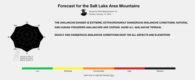
However, this year we have been thrown a curve ball and it is one of the reasons why I am not celebrating. That curve-ball was the prolonged dry period from December 10 to January 3, which ultimately led to the development of a persistent weak layer that is now buried by all of the snow that fell over the past couple of weeks. This led the Utah Avalanche Center to raise the black flag for extreme avalanche danger at all elevations and aspects on Sunday January 14.
 |
| Source: Utah Avalanche Center, issued 14 December 2024 |
About 30 years ago, when I was leaving Seattle for Salt Lake City, famed avalanche forecaster Sue Ferguson, a former director of the Utah and Northwest Avalanche Centers, told me that in Utah you can avoid many avalanches by simply waiting three days after a storm before entering into avalanche terrain. This was not meant to be rigorously followed advice as Sue knew as well as anyone that there is variance around the mean, but it was her way of saying that persistent weak layers are less common here and that patience is a virtue in Utah where we are often dealing with new snow and wind-driven instabilities that can heal quickly.
However, there are years when that is clearly not the case and this is one of them. That persistent weak layer may have strengthened some in some areas, but we are still dealing with a Russian Roulette snowpack. We still have considerable avalanche danger on a good portion of the avalanche rose and, as summarized by Drew Hardesty in today's report "dangerous and tricky avalanche conditions exist."
Drew comments further that cautious route finding and conservative decision making are essential. Indeed, many people that I know are laying low right now, staying away from of steep terrain.
So, Steenburgh winter is here, but the green light is not on in the backcountry. That said, the coverage is good in the aspens and reports are that the resort skiing has been quite good (I was in Steamboat last week and the snow conditions there were also quite good). It is always good to reach 100" of snow depth and 20" of water at the Snowbird SNOTEL in January. In the case of the latter, the median snowpack doesn't reach 20" until February 1st.


I was on a ski trip in Golden, BC when this was posted. With the increase in latitude decreasing the sun angle, what is the date for Golden, BC “when the sun angle begins to have an increasingly caustic effect on the snow”? Mind elaborating on the end date of good backcountry potential at or around others resorts in the west as we go north (in regards to sun angle) Big Sky, Schweitzer, Revelstoke, Eaglecrest, Alyeska….
ReplyDeleteI calculated this when Jim first described "Steenburgh winter" as I go snowcat skiing in Canada every year. I used 40 degrees latitude on Feb. 10 to determine sun intensity at various slope angles and aspects and then changed the latitude parameter to 40 degrees. I came up with March 6 as the date those sun intensities were most similar at 50 degrees.
Delete