
I hope you are enjoying the pleasantly moist and cool weather this Sunday. We've had a pretty good run of monsoon moisture and thunderstorms in recent days and I think it is quite enjoyable.
Weather observations over the past 14 days, roughly covering the first 2 weeks of August, show three major surges of monsoon moisture during which dewpoints (blue line) predominantly sat near or above 55˚F. These are separated by a couple of monsoon breaks during which the dewpoint was generally below 55˚F.

Despite the hit-and-miss nature of monsoon showers and thunderstorms, most of northwest Utah has gotten a good deal of rain, with widespread areas over an inch and local accumulations of more than 3 inches in places over the past 14 days.
 |
| Source: https://water.weather.gov/precip/ |
For our part of the world, that represents more than 300% of average for the period, although there are a few spots that haven't done as well (note that there are a lot of artifacts in the analyses above and below that are non-physical, so don't take them too literally.
 |
| Source: https://water.weather.gov/precip/ |
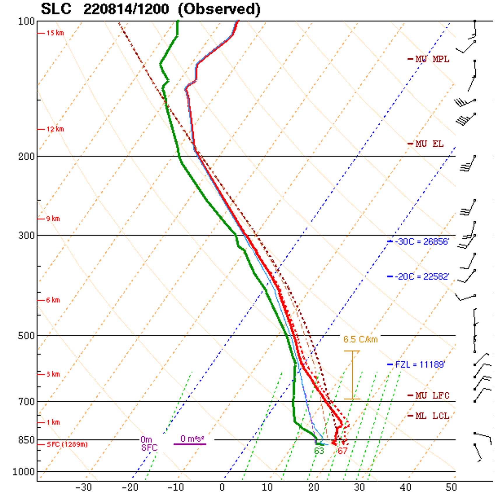
This morning's sounding is an interesting one. The atmosphere was at or near saturation at upper levels (above 600 mb) which explains the mid-level stratus deck that we've seen for most of the day so far (more on this in a minute). However, it is also fairly moist near the valley floor. At the time the sounding was taken, the surface temperature and dewpoint were 67˚F and 63˚F, representing a relative humidity of 87%.
While I was mountain biking this morning, I took the photo below at 9:33 AM from the upper towers on the ridge above Ensign Peak. The mid-level stratus deck was evident, but there were no low clouds.

By 10:11 AM, however, as I was returning home, one could see a band of low clouds had formed near the Wasatch.

As I write this, at 1:04 PM, the cloud band persists.

My guess is that it is being produced by the up-valley and upslope flows generated by daytime surface heating. Much of the time around here in the summer, the valley atmosphere is to dry to generate a cloud band at such a low elevation, but that's not the case today as the relative humidity is high at low levels. Additionally, the valley atmosphere is likely capped by a stable layer at about mid-mountain level, similar to what sometimes happens during winter inversions, so the up-valley and upslope flows are not penetrating through deep layer, but instead are capped at about mid-mountain level. This is preventing deep penetration of the upslope flow vertically. Instead, it hits the the stable layer, or "lid," and moves back over the valley aloft.

These sorts of mid-slope valley clouds can be found in many mountain valleys. Below is an example of one from the Inn Valley in Austria (see also our post Mid-Slope Valley Clouds from 31 January 2019).

Perhaps today's cloud band is destined to die at some point today. With surface heating, the valley atmosphere may dry out some, and the cloud band will dissipate. Really, such a cloud band is about a zero on a meteorological scale of 1 to 10, but it does help us to understand the local flows in our part of the world.
No comments:
Post a Comment