Apparently the phrase "dog days of summer" originates with the Greeks and Romans, who recognized that the hottest, most miserable part of the summer occurred in late July when the constellation Sirius rises along-side the sun in Late July.
However, the Greeks and Romans didn't live in Salt Lake City in the 21st century when the dog days just seem to go on and on.
Really, late July is climatologically the hottest part of the year here and that was the case this year. The hottest days of the year, in terms of average temperature, were July 17 and July 22 (91.5 and 91.0˚F, respectively). Given the long nights, we won't be touching that this week or weekend, but it's going to be hot.
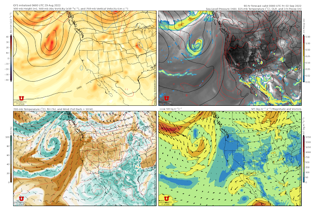
Below is the GFS forecast valid 0000 UTC 2 September (6 PM MDT Thursday). Monsoon moisture is confined mainly to southern Arizona and New Mexico and ridging predominates to our west. 700-mb temperatures at KSLC are around 16–17˚C. The long-term median for Sep 1 is about 10˚C and the highest ever observed after 23 August is 17.2˚C.
In other words, this airmass is quite warm for so late in the year.
Sadly, that means an extended run, beginning tomorrow, with highs in the upper 90s to near 100. At least the shorter days, low humidity, lower angle sun, and overnight lows near 70 should make it a little more tolerable than the true dog days in late July.


The local forecast discussion for SLC currently reads like something out of a climafiction novel.
ReplyDeleteSo if global average surface temperature has only increased 1.1 C and we are what 7 C or more above average for our holiday weekend then who in the world is getting a nice -6 C deviation from normal. They owe us some beer.
ReplyDeletehttps://climatereanalyzer.org/reanalysis/daily_maps/?dm_id=world-ced&wm_id=t2anom&year=2022
DeleteIt will be interesting to see what temperatures are reached with this big ridge. Forecasts for Tri-Cities for tomorrow are in the 104-109F range, which would be incredible since Pasco airport has never exceeded 101F in September, though the airport can be wonky at times (e.g., my house a couple hundred feet higher than the airport was 102F yesterday and the airport was 99F, maybe affected by irrigation). And then I see the possibility of several degrees above 100F in SLC this weekend, decently higher than any recorded September temperature.
ReplyDeleteDuration, duration, duration. It's quite a run of insanely hot temps through early next week in KSLC. It is worth nothing that after 2 Sep, the highest 700-mb temp on record is 16.4˚C. Forecast values are frequently at or above that this weekend, peaking at 18.6 Saturday night.
DeleteTrue. At least we are starting to finally get some trough passages to cool us down for a couple days at a time (though this comes with winds and fire anxiety). Hopefully, they will start making it down to SLC before too long.
Delete