 |
| Source: NCAR/RAL |
I suspect many people were surprised by this event and indeed it was a low probability possibility just two and a half days prior. For example, below is a plume of downscaled Short-Range Ensemble Forecast system (SREF) forecasts for the Salt Lake City International Airport. There are 26 forecast members that make up the SREF and 23 of those members produced less than 0.1" of precipitation and most produced a few hundredths or less.
Another perspective on that forecast is provided below. The ensemble mean precipitation is less than 0.1" across much of northern Utah except in the Uintas and the far north. However, the ensemble maximum precipitation exceeds 0.5 inches in several areas.
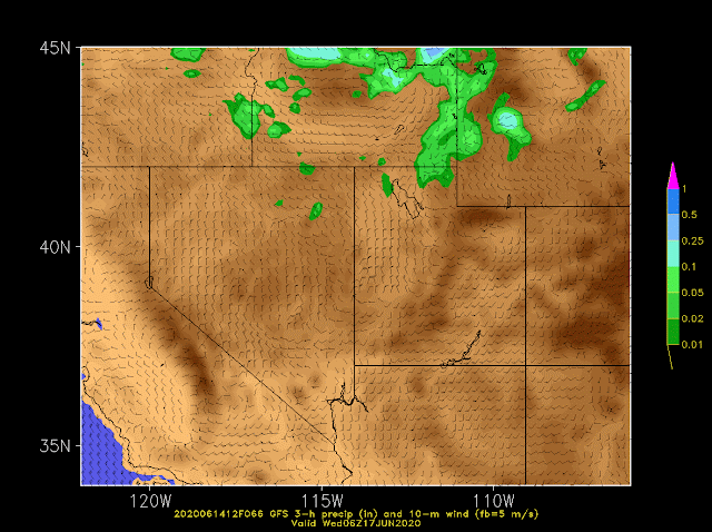
Another perspective is provided by the sequence of GFS forecasts below, which are 66, 54, 42, 30, and 18 hour forecasts of 6-hour accumulated precipitation (color fill) and instantaneous wind valid 0600 UTC (0000 MDT) 17 June (i.e. midnight local time last night). Note how these forecasts initially kept scattered precipitation to our north, but trended to more widespread and heavier precipitation further south over time (but still not as much as observed).

Finally, let's take a look at the evolution of NWS forecasts during this period. To do this, I'll use their zone forecast products issued for the Salt Lake Valley at the times indicated below. I'l begin with the forecast issued Sunday as it had no hint of precipitation.
- 230 PM MDT Sun June 14: TUESDAY NIGHT...Mostly cloudy. Cooler. Lows around 50.
- 259 AM MDT Mon June 15: TUESDAY NIGHT...A slight chance of showers and thunderstorms in the evening, then a chance of rain showers after midnight. Mostly cloudy. Cooler. Lows around 50. North winds 10 to 20 mph around midnight. Chance of precipitation 30 percent.
- 245 PM MDT Mon June 15: TUESDAY NIGHT...Mostly cloudy with a 50 percent chance of rain showers. Cooler. Lows around 50. Northwest winds 10 to 20 mph.
- 251 AM MDT Tue June 16: TONIGHT...Partly cloudy with a chance of rain showers and a slight chance of thunderstorms in the evening, then cloudy with rain showers likely and isolated thunderstorms after midnight. Cooler. Lows around 50. North winds 10 to 20 mph. Chance of precipitation 60 percent.
- 1022 AM MDT Tue June 16: TONIGHT...Scattered showers and thunderstorms in the evening, then numerous rain showers after midnight. Mostly cloudy. Lows in the lower 50s. North winds 10 to 20 mph. Chance of precipitation 60 percent.
- 202 PM MDT Tue June 16: TONIGHT...Mostly clear with scattered rain showers and isolated thunderstorms in the evening, then mostly cloudy with numerous rain showers after midnight. Lows in the lower 50s. North winds 10 to 20 mph. Chance of precipitation 70 percent.
So you can see how on Sunday, no precipitation was in the forecast, and then how the forecast evolved with time with increasing chances of measurable precipitation.
The forecast issued at 230 PM Sun June 14 for the northern Wasatch Front was mostly cloudy with a 20 percent chance of rain showers and for the Cache Valley was mostly cloudy with a 40% chance of rain showers.
So, this was a case in which "the model trend was not our friend." The rain late yesterday and overnight was significant, exceeding the maximum precipitation at some sites for the calendar day (e.g., Logan, Ogden). I think it is safe to say that forecasts issued on Sunday did not prepare the public for such a significant event. This reflects a number of factors, including the evolving nature of the storm system, shortcomings in our current forecast systems, and limitations in how we currently communicate forecast uncertainty.
It is a reminder to all of us who work in the weather enterprise that we have a lot of work to do.


"This reflects a number of factors, including the evolving nature of the storm system, shortcomings in our current forecast systems, and limitations in how we currently communicate forecast uncertainty."
ReplyDeleteIn regards to the last sentence, any insight on what part of the storm system caused the uncertainty, as say compared to the precipitation event we had I think two weekends ago, which seemed to be more certain in regards to its forecast.
I didn't have time to look into that. The short, unsatisfying answer is that the jet-stream pattern amplified more than originally forecast, resulting in a deeper trough that pushed the precipitation down into our area. Why that happened is less clear and requires more time to investigate than I have.
Delete