 |
| Source: Time Magazine |
Where Rossby enters into our story is in his pioneering work to describe and understand the jet stream and upper-level waves, the latter known today as Rossby Waves. Most of us are familiar with waves. For example, we've all observed waves at the ocean or on other bodies of water. Such waves are gravity waves, in that gravity plays a dominant role in their evolution, including their speed.
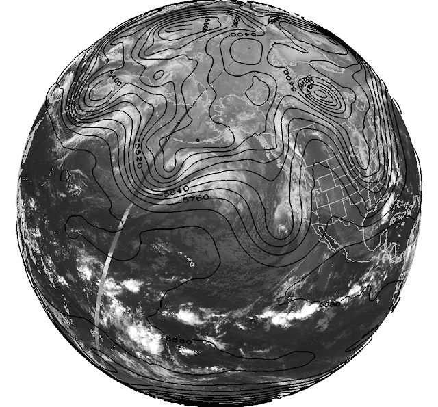
Rossby waves are large-scale waves in the atmosphere. The ridges and troughs found at upper levels in the atmosphere, for example, are Rossby waves. Meteorologists commonly use maps of 500-mb geopotential height — basically a topographic map of the 500-mb surface — to identify these ridges and troughs. Below is this morning's 500-mb analysis showing the Rossby-wave pattern over western North America and the North Pacific. Notice the sequence of ridges and troughs that begin in Asia and extend to North America (a look at the opposite hemisphere would show that this wave-like pattern extends around the Earth).
In this pattern, the distance from trough to trough or ridge to ridge spans about 45º longitude, equating to a wavelength of about 3000–4000 km at this latitude. A careful look reveals some waves with shorter wavelengths, but the large-scale waves dominate the current upper-level pattern.
In contrast to gravity waves on water, the primary driver of Rossby wave behavior is not gravity but the rotation of the Earth. This rotation causes Rossby waves to move more slowly than the background flow, so that the air moves through the waves. This effect is most pronounced for longer waves than shorter waves. As a result, long waves in the midlatitudes tend to move more slowly to the east and in some cases they can even move westward (upstream). Because of these differences in speed, short waves are often seen moving through the long wave pattern. Meteorologists sometimes say that the short waves are "steered" by the long-wave pattern.
Now let's get back to how Rossby is ruining your weekends. The wave pattern we are presently in has a period of about 7-10 days and the passing of ridges and troughs has produced the typical ups-and-downs in the local weather here in northern Utah. Check out the weather last month. A peak in temperatures from the 8th to 12th, a minimum, accompanied by precipitation, from about the 13th to 17th, a peak again around the 21st, and then a broad minimum with precipitation toward the end of the month.
The net result has been that I'll call "troughy" weather the weekend of the April 16 and 17, the weekend of April 23 and 24, and the weekend of April 30 and May 1. The correspondence is not quite perfect, but it's close enough.
Of course, if instead of yard work, golfing, or biking you were looking for snow, Rossby has been your friend, not your enemy.


At first glance of the title, I have to admit, I was curious how the Carl-Gustaf recoilless rifle kept ruining my weekends.
ReplyDeleteHa ha. Never heard of it before!
Delete