Tuesday, May 31, 2011

Alta 800!

Does this Memorial Day pow put Alta over 800" for
the winter? Photo: T. Cruickshank
Has Alta hit the coveted 800" mark for the winter?  Call it psuedoscience if you will, but with a little creativity, here's what I come up with for the year.

The snowfall history on the Alta web page reports a cumulative season snow total of 723.5" since 1 October and 681.5" since 1 November.  I believe this is based on twice-daily snowfall observations from the Collins observing site, which is located just above mid-mountain at 9662 feet elevation in Collins Gulch.

Such observations have not, however, been collected at Alta-Collins since 1 May.  Thus, we need to be creative to get the total through May.

Fortunately, snowfall observations are also collected at Alta by the Utah Department of Transportation (UDOT) at the so-called guard station across from the base of the ski area at 8700 feet elevation.  From 1 Nov - 30 Apr, they recorded 553" of snow, 128.5" (23%) less snow than reported by Alta.  

Before you blame this difference on ski-area marketing, I'd like to note that it does make some meteorological sense.

First, the Alta-Collins site is almost 1000 feet higher.  That might not sound like much, but based on long-term records collected at the bottom of the Cottonwood Canyons and Alta, the mean annual snowfall in the Wasatch Range increases a bit more than 100"/1000 feet of elevation.  That may be a bit high, however, for altitudes above 8500 feet where most of the precipitation falls as snow, but the increase in snowfall with altitude likely explains a significant fraction of the difference between the observing sites.

Second, UDOT's snowfall is based on 24 hour accumulations, which inevitably results in lower snow totals due to settlement.  Ideally, snowfall is measured at the time of peak accumulation, but this is simply  not practical in most instances.  So, the frequency of measurement probably accounts for another chunk of the difference.

So, let's assume the difference between the two sites reflects a combination of meteorological factors and sampling frequency and plod forward.  We can now estimate the May snowfall at Alta-Collins by increasing that recorded at the UDOT site (64") by 23%, which gives 79".

If we add that to the 723.5" recorded through May we get a grand total of.................

802.5 inches!!! 

There you have it.  Now, let the yelling and screaming about whether or not 802.5" has actually fallen at Alta-Collins begin :-).

Revised Paper on Sierra Effects on Intermountain Cold Fronts

Source: West and Steenburgh (2011)
After a long and arduous rewrite, my paper with Greg West on the Influence of the Sierra Nevada on Intermountain cold-front evolution has finally been accepted by Monthly Weather Review.  If you are an aficionado of Intermountain weather, this is a must read as it will probably cause you to think differently about how the Sierra influence cold fronts as they move across the Intermountain West.

The paper may be downloaded by clicking here.  Comments appreciated of course.

Monday, May 30, 2011

Smoke from my Memorial Day BBQ

We discussed the possibility of a cold snowy Memorial Day back on Friday, but I still feel like I'm in a time warp or Twilight Zone episode.  I woke up this morning and there was snow on the ground at my house in the Avenues. 


Then, I went out and picked up the paper and they had delivered a Deseret News instead of a Salt Lake Tribune.  Weird...

In the Collins lot, there were so many cars I had to check to see that the lifts weren't running.  

Alta, 30 May 2011.  10" of new snow.  192" snow depth.
Skinning up Collins Gulch, the cover was about as good as you'll ever see it.


Nearing the ridge, fighting the wind, it certainly felt more like February than May.

Yours truly sucking wind.  Photo: Tyler Cruickshank
And then the turns.  A bit inconsistent and stiff in places, but pretty much as good as you can get on Memorial Day.  

Tyler Cruickshank samples the smoke at my Memorial
Day BBQ.  May 30?  Yeah, right.  
Yours truly.  I love it when a forecast comes together!
Photo: Tyler Cruickshank
Weather forecasts aren't perfect, but do you realize what an achievement that it is that we can anticipate an event like this more than three days in advance?  Numerical weather prediction is one of the great scientific advances of the past 100 years, and it's only going to get better.

Sunday, May 29, 2011

Memorial Day Powder Prospects

As discussed on Friday, the doom and gloom has returned to the Wasatch Front for the latter two days of the Memorial Day weekend.

Snowbird reported 4" of new snow this morning, while the depth at the Alta-Collins snowstake has increased from 179" to 184".

More snow is expected in the Wasatch through Memorial Day.  In particular, the NAM model is going for about .6" of snow water equivalent at Alta-Collins from early tmomorrow morning through tomorrow afternoon, with a forecast snow-density of about 10%.


It won't be the Greatest Snow on Earth, but tomorrow will provide an opportunity for Memorial Day freshies...and perhaps even good skiing at the upper elevations.  Bring your googles because if the NAM model verifies, there will be storm skiing in the morning.

NAM Model forecast valid 9 AM 30 May 2011.
Snowbird's seasonal total is now up to 765".  By this time tomorrow, I expect they will be over 775".

Saturday, May 28, 2011

Memorial Weekend Ski Report and Measuring Snow

Today we hit Snowbird and although we didn't ski the Greatest Snow on Earth, the turns were really outstanding for Memorial Day weekend.  Early in the morning we enjoyed some creamy skiing in Mineral Basin, with the snow nicely softened by the morning sun.

The cover is absolutely amazing.  This is the year to ski lines like the pipeline that's for sure.  I snapped the photo below on the Peruvian chair only because if you didn't look at the calendar, you'd swear it was early March instead of late May.


We've discussed the problems measuring snow on several occasions, most recently with regards to the Alta snowfall record.  There's a nice article discussing these problems and recent efforts to address them in an article in the latest UCAR quarterly entitled How Deep the Snow?  Enjoy!

Friday, May 27, 2011

Memorial Day Pow?

Endless winter continues in the Intermountain West this weekend.

The "warmest" weather comes today (Friday) and tomorrow (Saturday) in advance of an approaching upper-level trough from the west.  With a strong baroclinic zone draped across the state today and tomorrow, temperatures will be much higher in southern Utah than northern Utah.

NAM Model forecast valid noon Saturday 28 May 2011.
By Sunday, however, the trough has amplified and moved into Nevada, with a band of precipitation forecast to be sitting over northern Utah.  Further, 700-mb temperatures along the Wasatch Front have cooled to about -4 C.  Thus, we'll see snow levels dropping to about 8000 feet.  Southeast Utah remains, however, ahead of the developing front and remains in the warm air, albeit with strong winds and potentially blowing dust.

NAM Model forecast valid noon Sunday 29 May 2011.
By Monday there's no escape as cool air has spread across the whole state.  With cool, moist westerly flow over northern Utah, skiers might just get the goods again in the Wasatch Range.  The NAM forecast 700 mb temperatures are less than -6C, so snow levels will probably be down to 7000 feet, lower during periods of heavy precipitation.

NAM Model forecast valid noon Monday 30 May 2011.
I won't be the least bit surprised if I see some snow or ice pellets at my house in the upper Avenues on Monday.  For the mountains, we'll have to wait and see if it snows enough to create decent conditions, but it bears watching and being ready for that one last powder day.

Of course, the way things are going this year, perhaps it will snow until the 4th of July...

Thursday, May 26, 2011

Great Salt Lake Seiche and Runoff Rise

One of my graduate students, Trevor Alcott, noticed this morning that there was a remarkable seiche on the Great Salt Lake thanks to the overnight cold-frontal passage. A seiche is a temporary rise (or fall) in lake level that can be caused by strong winds, earthquakes, and other phenomenon.

At the Saline USGS lake-level observing site, which is located on Promontory Point and in the north arm of the lake, the lake-level averaged about 4196.2 feet from 19–24 May.  On the 25th, however, the lake-level decreased gradually, followed by a rapid spike to 4197.7 feet early in the morning on the 26th (today).  

Source: USGS.  Times appear to be MST or MDT.
Why did this happen?  Note the persistent easterly flow during the day at Gunnison Island, which veered slightly to SE with the approach of the front at roughly midnight MDT.  During this period, the lake-level at Saline decreased as the wind transported water to the western side of the Great Salt Lake.


After midnight, the front passed and the winds shifted rapidly to NW–N, with a gust of as high as 45 mph at 1 am MDT.  As a result, water "sloshed" rapidly across the Great Salt Lake and the lake-level spiked rapidly at Saline.

Following the spike, the lake-level oscillates, which is consistent with a sloshing of water back and forth across the lake.  An industrious student could easily calculate the period and speed of this wave as it moves back and forth across the lake.  

Looking at a longer time scale, the elevation of the Great Salt Lake at the Saltair Boat Harbor has increased almost 3 feet since January.  And the runoff is just getting started! 

Source: USGS
We're still in the lower half of the historic range of the GSL, which is about 4192–4212 feet, so let the restoration project continue!  

Overnight Fropa

By nighttime standards, we had a pretty good frontal passage (fropa) last night.  At KSLC, note the abrupt drop in temperature and increase in wind speed (with a gust to 49 mph) at about 0930 UTC (3:30 am MST).


The radar at this time showed an abrupt transition in radar reflectivity with considerable "clear air return" in the post-frontal environment.


It looks to be a bit dusty around the Salt Lake Valley this morning.  Thus, it appears the strong post-frontal winds picked up some dust from Nevada and/or the West Desert and transported it into our area.

Tuesday, May 24, 2011

U2 Forecast


Correct me if I'm wrong, but I can't think of a good U2 song that is weather related.  Bullet the Blue Sky uses weather in a metaphorical sense, but that is such a strong protest song that it doesn't seem appropriate to use it for weather.  Thus, the video above is simply of one of the great live songs from an era when my generation realized we were witnessing what would become the biggest band in the world.

I just took a look at the latest (0600 UTC) model runs and I'm optimistic that the weather will improve for the show this evening.  The NAM and GFS are bringing in drier air and are stabilizing things aloft.  The NAM model sounding for 8 PM MST, just before U2 takes the stage (scheduled for 8:45) looks pretty good with a healthy stable layer down to about 650 mb.


Keep your fingers crossed the models are on track and it will be dry for the concert.  One aspect of the forecast is easy.  You can count on U2 to put on a great show.  Enjoy!

Monday, May 23, 2011

Tornado FAQ

Given the interest in tornadoes because of the large number of fatalities this year, I'd like to point everyone to an excellent FAQ prepared by Roger Edwards of the NOAA Storm Prediction Center.

Roger Edwards' Tornado FAQ.  Everything you want to know
about tornadoes, but were afraid to ask.

Joplin Tornado

Another tragic tornado has rumbled through the midwest.  Below are radar reflectivity and velocity images from yesterday afternoon's event in Joplin, MO.


Seen at center left is the remarkable signature of a mesocyclone.  In particular, note the incredible hook-like appearance in the Doppler velocity analysis.  One of our readers wanted a cross section, but I'm operating in mobile fashion and don't have all my tools at my fingertips.

Unlike most meteorologists, I have no interest in seeing another tornado after watching the 1999 Salt Lake event rumble through my neighborhood.  I prefer storm chasing Utah style, which involves deep powder skiing in the Wasatch Range.

Saturday, May 21, 2011

The End of the World as We Know It


May 21, 2011 is here and the end of the world is coming, at 6 PM to be precise, according to California preacher Harold Camping. 

I suspect the day will go by without incident, other than some complaints about the flexible hours at Snowbird today.  According to their mountain report:

"[Snowbird] will open at 8am today. There will be limited terrain accessed by Peruvian Express, Mineral Basin and Little Cloud. The skiing and riding is recommended for experts only. It is possible the mountain will close at noon, if conditions permit we will remain open until between 1:30pm-2:00pm. Lift tickets today will be $50."

Preacher Camping and other end-of-the-world types like to pick a day that the world will end,  but that "day" won't come until a few billion years in the future when the sun exhausts it's nuclear fuel and expands into a red giant.  Oh what a party that will be!

Micheal Stipe of REM, however, sings about something altogether different, the end of the world as we know it.  That's a very clever addition as the end of the world as we know it doesn't have to involve a cataclysmic event that results in the end of humankind.  

In fact, the end of the world as we know it could be happening right before our eyes.  Here I'm defining, as we know it to mean since the emergence of human civilization several thousand years ago.

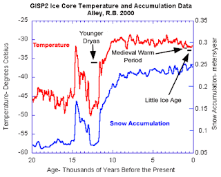
Ice core records suggest a period of remarkable and rapid warming occurred about 12,000 years ago at the end of the Younger Dryas, a period of cold, dry climate that lasted about 1200 years.  Since that time, our species has experienced a relatively warm and stable climate.

Source: NOAA, NRC
But the climate is shifting and recent warming is very likely due to the buildup of greenhouse gases in the atmosphere from human activity.  This warming is, to quote the IPCC, unequivocal, and evident throughout the climate system.

We're not talking about the end of the world, but are we seeing the early stages of a climate shift that will change the world as we know it?

I guess we'll find out.  

Friday, May 20, 2011

From the Gulf of Mexico with Love


Have You Ever Seen the Rain by Credence Clearwater Revival is one of the great weather songs of all time (although in the song, rain is probably used metaphorically) and it just seems perfect for today.

One of our readers brought up the possibility that some of the moisture from this ongoing storm originates with the Gulf of Mexico.  I may take a closer look at this today, but I did want to point out the tremendous plume of high precipitable water that wraps around the cyclone from the Gulf of Mexico, into the High Plains, across Montana and Idaho, and then into northern Utah.  Incredible!

1200 UTC IR satellite and radar imagery with GFS
precipitable water and 700-mb wind vectors
Typically tracing moisture in storms is more complicated than you think, in part because the sources can vary considerably depending on what altitude you are looking at.  Nevertheless, at least for the late stages of this storm, it does appear the Gulf of Mexico is playing a role.  Who would have "thunk" that, especially given the fact that the flow over Utah is out of the north?  As the Grateful Dead sang, "what a long strange trip it's been....".

Thursday, May 19, 2011

Perspectives on the Rain

This has been and continues to be a fascinating storm for northern Utah.  I'm about as close to developing seasonal affective disorder as I've been since I left Seattle 16 years ago.

At KSLC, it seems like it has been raining continuously since 1400 UTC (0800 am) yesterday morning, although there were some breaks overnight from 0150-0426 UTC and 0519-0805 UTC.  

An interesting aspect of this event is that it has rained everywhere.  As of 7 am this morning:
  • .87" in Logan
  • 1.7", 1.59", 1.3" in Centerville, Bountiful, and Ogden, respectively
  • 2.21", 1.6", 1.35", 1.0", and .82" in Cottonwood Heights, Taylorsville, Sandy, KSLC airport, and the Great Salt Lake Marina, respectively
  • .32-2.36" in the West Desert, including 1.51" at Aragonite
  • 1.21", .91" and .73" on the Wasatch Back at Weber River near Morgan, PC Golf Course, and Kimball Junction, respectively
  • 2.8" and 2.3" at the Harbscrabble and Farmington SNOTEL stations
  • 2.62" and 1.97" at Brighton Crest and Alta UDOT
This coverage is quite remarkable, exhibits fairly limited orographic enhancement, and is occurring in large-scale easterly flow at upper-levels.  

The precipitation dynamics of this event are quite complex, but I'll try to summarize here about some of the key aspects.  First, we have a situation where we have a trough camped out pretty much right over us.  Further, even though the upper level flow has been out of the east, northeast, and north, it is associated with large-scale warm advection.

For example, at 0000 UTC yesterday afternoon, note the inverted sea level pressure trough and confluent wind shift that extends through Utah and into Idaho (lower right panel).  It sits pretty much right over northern Utah.  Meanwhile, at 700 mb (lower left panel), there is weak warm advection over northern Utah.  Note how the flow is NE–N along the Utah–Idaho border, but there is actually warm air to the north.  


This has created a remarkable situation where we have large-scale ascent in the flow aloft generating large-scale precipitation.  Even though this flow has an easterly component, it is not downsloping on the west side of the Wasatch because there is a shallow layer of stable W–NW flow at low levels.  For example, the KSLC sounding from 0000 UTC yesterday afternoon shows westerly flow below 725 mb, above which the flow veers (i.e., turns clockwise) to NE and then E by 500 mb.  Note also the stable layer at the top of the western flow.  

Source: NWS/SPC
The trough pivoted somewhat overnight, but the general pattern remained largely the same.  The sounding at 1200 UTC this morning shows NW flow at low levels, veering to NE aloft, with a stable layer below about 675 mb.  


The MesoWest surface plot for 1733 UTC this morning shows the situation really well.  Note the NW flow over the West Desert, W flow along much of the Wasatch Front, but E flow over SW Wyoming.  


This is a complex event and there's much going on that I cannot cover, but this analysis shows that the positioning of the trough has created a situation we really don't have downslope occurring on either side of the Wasatch range.  There is no lee side at present, and, because of the high static stability at low levels, the flow aloft isn't really feeling the mountains,  It's just sliding along at the top of the stable layer. This is a contributing factor in the lack of contrast between lowland and mountain precipitation (although it is not the only one).  

What Is the Alta Snowfall Record?

Source: NWS
Note from Jim: Post updated 2:25 PM 19 May with correct information from Utah Weather and Climate. 

It's a pretty simple question really, "What is the Alta Snowfall Record?"  Good luck, however, finding a consistent answer.

According to the Western Region Climate Center, Utah's maximum winter snowfall is 846.8", set at Alta in 1982-83.

According to Utah Weather and Climate by Pope and Brough, the Alta "year" (Sep 1983–Jun 1984) snowfall record is 808.5" set in 1983–84 and the seasonal snowfall record is 743.5" set Nov 1983–Apr 1984

What gives?

There are several issues here.  First, what is the time period of the observations and what is meant by winter, year, or season.

There does not appear to be a definition of winter on the Western Region Climate Center, but I suspect they are actually referring to the water year, which is from Oct-Sep.

I don't know what the definition of season is.  Based on the Alta snowfall history page, the ski area presently uses Oct-Apr.  What they used in 1983-84 I don't know. Pope and Brough used Nov–Apr for Utah Weather and Climate.

Now, let me add some additional flies to the ointment.

The ski area presently collects observations on the upper mountain, but in the past has done it at the base.  It does snow more on the upper mountain.  Are we comparing apples and oranges?

The official record cited by the Western Region Climate Center is based on data from the Alta cooperative observer.  I suspect that data is probably not from the ski area, but instead UDOT or a volunteer at Alta (in fact, over the years different groups may have provided data).

The Western Region Climate Center lists four locations at Alta which data has been collected since 1948.  All have the same lat-lon: 40.36N, -111.38W.  Pump that into googlemaps and you get a location south of Heber!  Not exactly helpful...

Finally, we have the issue of whether or not the methods and location of the snowfall collection have been done consistently over the years, even if the official location has stayed the same.

Someone should pull the climate data for the Alta coop site from NCDC just so we can verify the seasonal and water-year records (volunteers?).  Once that's done, we can worry about all these other issues.

Then again, we could just go skiing...

May Pow

A remarkable 24" storm total has been reported as of 7 am this morning in upper Big and Little Cottonwood Canyons.

As an example of the challenges of measuring snow and snow density, the snow water equivalent in Big Cottonwood was 2.62", whereas it was 1.97" in Little Cottonwood, despite the fact that the site in Big Cottonwood is at a higher altitude.

Measurement challenges aside, this is a big May dump.  I especially like that Snowbird has given up on digging out their snowcam, although I miss being able to use it to assess snow rates.

Source: Snowbird.

Wednesday, May 18, 2011

Circulation Contrasts between 1983 and 2011

There have been many comparisons made lately between the spring of 1983, when flooding famously led to City Creek Canyon, and 2011.  

The floods of 1983 when City Creek was diverted down
State Street.  Source: Wikipedia Commons/US Government.
The two years are similar in that both featured an abundant mountain snowpack and a cool, wet spring that extended the snow accumulation season well into May.  This can be seen, for example, in the SNOTEL data for Ben Lomond Peak.  On average, snowpack snow water equivalent (SWE) at Ben Lomond Peak reaches a maximum of ~43" in early-mid April, whereas this year's peak of ~60" was reached just after May 1.  In 1983, we reached ~67" about May 20th!  What a year that was.   This year we've actually had a few snowmelt periods during late April and May, whereas in 1983 it just stayed cold and snowy right until the bitter end.  


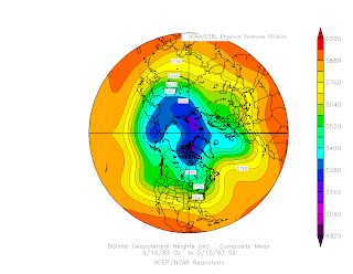
Although both springs were cool and wet, the large-scale circulations in the two years were markedly different.  The winter of 1982-83 featured one of the strongest El Nino's on record.  This led to an active subtropical jet and pronounced flow splitting over the western United States that persisted well into Spring.  The mean 500-mb heights for 15 Apr – 15 May 1983 show a strong Pacific jet extending across the western and central North Pacific, marked flow splitting over the eastern Pacific, and a deep trough centered off the California coast.

Source: NOAA/ESRL-PSD
In contrast, this past winter has been characterized by La Nina conditions.  The mean 500-mb heights show a structurally continuous jet extending across the entire North Pacific.  
Source: NOAA/ESRL-PSD
Since the circulation anomalies for this spring are subtle, it can be helpful to examine the departure of the 500-mb height from average.  From 15 Apr – 15 May there are positive height anomalies over the subtropical eastern Pacific that extend across the desert southwest into northern Mexico.  To the north, negative height anomalies are draped across the northern tier of the western 2/3 of the United States and southern tier of Canada.  Together, these anomalies produce a stronger jet (relative to climatology) over the western United States with an orientation that is not purely zonal (i.e., from west to east), but is oriented so that it is out of the WNW.   

Source NOAA/ESRL-PSD
Those anomalies by themselves are probably not going to produce the dramatic weather we've had this spring.  At issue is the potential role of circulation anomalies in the high latitudes.  In particular, note the pronounced negative height anomaly over northern Canada and positive height anomaly over the Bering Sea.  These anomalies open the door for colder high latitude air to feed over the Gulf of Alaska before penetrating into the western United States.  

So, we see there are a couple of different ways we can get a cold, wet spring in Utah.  Let's hope this one ends soon.  There's moss growing between my toes.    

Tuesday, May 17, 2011

April Temperatures in Context


It has certainly been a cold spring in Utah, but how cold?  Has Hell frozen over?  Is this the end of global warming?

According to the National Climatic Data Center, Utah's average temperature in April was below average, but only the 35th coolest of the past 117 Aprils.  If you want really cold, in relative terms, head further north to the Pacific Northwest where Washington observed its 2nd coldest April of the instrumented period.
Source: NCDC
The statewide average, however, is a bit deceptive for those of us who live in northern Utah where the departure from average was the largest in the state.  In contrast, southern Utah's departure from average was smaller or even slightly positive in a few spots.
Source: NCDC
At KSLC, the mean temperature for April was 45.4 F, 4.6F below the average for 1971-2000.  Not exactly BBQ weather, but it did make for good skiing.

As can be seen in the above analysis, we were a country divided in April with much below average temperatures in the Pacific Northwest and above average temperatures across much of the southern and eastern United States.  The former was strongly related to anomalous troughing over the Pacific Northwest that was connected with a deep anomalous trough over northern Canada and Greenland.  

Source: NOAA/ESRL-PSD
This anomalous circulation pattern resulted in the remarkably cool Spring we've had over Utah and is not at all reflective of the end of global warming.  According to NCDC, April's global-mean temperature was the 7th warmest since 1880, 1.06F above the 20th century average.   Although the Pacific Northwest was quite cool, it was remarkably warm across much of Eurasia.  The UK saw its warmest April on record and Germany its second warmest.  
All of this shows that weather, like politics, is local.  It has been a cold spring in Utah thanks to an anomalous large scale circulation, but the global-mean temperature remains well above the 20th century average.  


April shows the power that persistent, high amplitude, large-scale circulation anomalies have on local weather.  Mother Nature can still give us a cold winter or spring on a regional scale.  

Monday, May 16, 2011

Incredible Airmass Contrast

This is old news, but one of my students pointed out to me today that there was a mind-boggling contrast in airmass between Salt Lake (purple) and Elko (red/green) yesterday afternoon.


That's pretty much as large as they come around here with a surface temperature contrast of a whopping 27C and a 700-mb contrast of ~18C.  

Recipe for an Unsettled Week

Our numerical forecast models are the backbone of modern weather forecasting, but sometimes you can just look at an analysis an know what's coming.

That was the case this morning when I pulled up this satellite image and 500-mb height and absolute vorticity analysis.


In particular, there is not only a long-wave upper-level trough over the western United States, but another one upstream over the Gulf of Alaska.  This upstream trough is also strongly diffluent, meaning that there is strong diffluence or spreading of the flow on the downstream side of the trough.  Further, the trough is negatively tilted, which means that the trough axis isn't oriented meridionally (i.e., along a meridian) but instead along a SE-NW axis.

In such a configuration, the strongest cyclonic vorticity advection lies in or near the base of the trough axis, which results in the trough digging (i.e., plunging southward) as it moves eastward.  In the configuration above, that means this trough will essentially dig into the downstream trough, reinforcing it and extending the round of cool, unsettled weather for the western United States.

All of this is terrible news for the Tour of California, which was formerly held in February, but is now being held in May in the hopes of better weather.  In a quote that sums up the situation perfectly, Andrew Messic, President of AEG sports, the presenter of the race said, "Two years ago, when we decided to move the race from February to May, we did it so we wouldn't get rained on, which was successful, but now we have snow."

I-80 traffic cam just west of Truckee, CA.
Source: CalTrans
Stage 1, which was scheduled for yesterday and would have been a spectacular race around Lake Tahoe was cancelled.  The start for today's Stage 2 has been shifted from Squaw Valley (~6000 ft) to Nevada City, CA (~2500 ft) and will not longer go over Donner Pass.

Sunday, May 15, 2011

Hatu Winds and Blowing Dust

We've gone from a morning canyon wind event to an afternoon with screaming southerly winds.  I always wanted to call these strong southerlies the "Intermountain Scirocco" as they bear many similarities to the Scirocco winds of North Africa, but Mark Eubank once told me he called them the Hatu winds for Utah spelled backwards.  Hatu it is...

First, let's have a look at some of the winds out there.  At 0018 UTC 16 May, several stations in the west desert and over the Great Salt Lake are reporting gusts in excess of 50 mph.

0018 UTC 16 May MesoWest surface plot.
Wind gusts in mph annotated.
Grassey Knolls along I-80 just west of the Cedar Mountains had a peak gust earlier today of 66 miles per hour.  Not exactly fun for high profile vehicles.


The nearby UDOT traffic camera shows dusty conditions too.


Where is this dust coming from?  Well, a lot of it appears to be coming from three point sources in southern Utah, as evident in this enhanced MODIS image.

Source: NRL
I suspect the biggest offender is the Sevier Lake bed, which has played a role in Salt Lake dust storms in the past.  Thus far today, the flow has been southerly and the dust plume has been west of Salt Lake, but that's changing now as the flow is veering to southwesterly and the Oquirrhs have just disappeared.  I suspect we'll be seeing dust in the Salt Lake Valley soon.