 |
| The floods of 1983 when City Creek was diverted down State Street. Source: Wikipedia Commons/US Government. |
The two years are similar in that both featured an abundant mountain snowpack and a cool, wet spring that extended the snow accumulation season well into May. This can be seen, for example, in the SNOTEL data for Ben Lomond Peak. On average, snowpack snow water equivalent (SWE) at Ben Lomond Peak reaches a maximum of ~43" in early-mid April, whereas this year's peak of ~60" was reached just after May 1. In 1983, we reached ~67" about May 20th! What a year that was. This year we've actually had a few snowmelt periods during late April and May, whereas in 1983 it just stayed cold and snowy right until the bitter end.
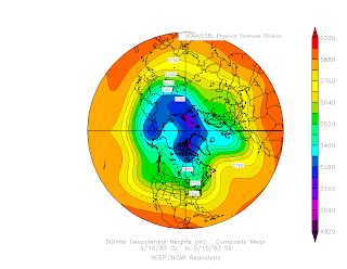
Although both springs were cool and wet, the large-scale circulations in the two years were markedly different. The winter of 1982-83 featured one of the strongest El Nino's on record. This led to an active subtropical jet and pronounced flow splitting over the western United States that persisted well into Spring. The mean 500-mb heights for 15 Apr – 15 May 1983 show a strong Pacific jet extending across the western and central North Pacific, marked flow splitting over the eastern Pacific, and a deep trough centered off the California coast.
 |
| Source: NOAA/ESRL-PSD |
In contrast, this past winter has been characterized by La Nina conditions. The mean 500-mb heights show a structurally continuous jet extending across the entire North Pacific.
 |
| Source: NOAA/ESRL-PSD |
Since the circulation anomalies for this spring are subtle, it can be helpful to examine the departure of the 500-mb height from average. From 15 Apr – 15 May there are positive height anomalies over the subtropical eastern Pacific that extend across the desert southwest into northern Mexico. To the north, negative height anomalies are draped across the northern tier of the western 2/3 of the United States and southern tier of Canada. Together, these anomalies produce a stronger jet (relative to climatology) over the western United States with an orientation that is not purely zonal (i.e., from west to east), but is oriented so that it is out of the WNW.
Those anomalies by themselves are probably not going to produce the dramatic weather we've had this spring. At issue is the potential role of circulation anomalies in the high latitudes. In particular, note the pronounced negative height anomaly over northern Canada and positive height anomaly over the Bering Sea. These anomalies open the door for colder high latitude air to feed over the Gulf of Alaska before penetrating into the western United States.
So, we see there are a couple of different ways we can get a cold, wet spring in Utah. Let's hope this one ends soon. There's moss growing between my toes.


Just returned from a road trip through the Northwest... it looks almost as green here as the Portland/Seattle area. They are a lot colder and wetter than normal as well.
ReplyDeleteI see that Snowbird still has over 70" of snow water... perhaps they are starting to work on next year's snowpack (?).
Didn't the Thistle Landslide happen in '82/83 too? That's probably something to be concerned about in the Wasatch back country when the big melt comes.
ReplyDeleteI don't know anything about landslides, but it has happened near Jackson. There's a great video at http://www.facebook.com/video/video.php?v=1558512783034&oid=288387851340&comments. I especially like the dude riding the slide in the middle of the video.
ReplyDelete