
Just check out these GEFS forecasts from this morning.
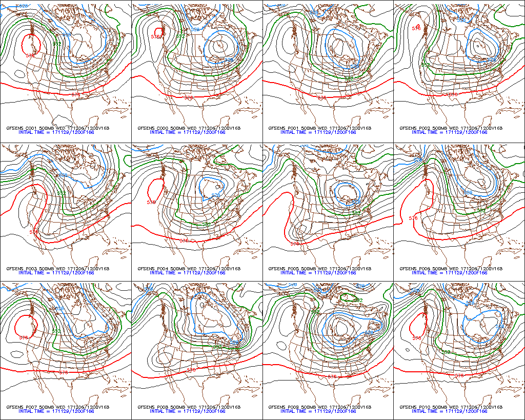 |
| Penn State E-wall |

I've been in denial about these forecasts for a few days, hoping that we might get something Sunday/Monday for storm chasing and to help the skiing some, but it hit me today that we could be hosed big time.
Let's put the situation into historical perspective. Records for the Snowbird SNOTEL cover 29 years. Time series of snowpack water equivalent from 1 October to 1 February are provided below. We currently sit at 3.1 inches, which I've circled below. There are only 2 water years with less snow, 2000 and 2010.
 |
| Source: NWS |
That wouldn't be cause for panic, but that block scares the bejesus out of me. I stuck an arrow for the future on the graph, assuming we get perhaps 0.5" of water out of the Sunday/Monday storm (it could be more or less, but I lean toward less). We would go through the first week of December near the lowest snowpack in that 29 years. If instead we hold at the current snowpack, 3.1 inches would match the low for Dec 10 set in 2010.
Although there is some uncertainty in the SNOTEL data, we're near the bottom of the barrel. Note that the SNOTEL records don't go back to 1976/77, better known as the "drought year", when only 13.5" fell in November and 17" in December at Alta. That year may have been worse.
Bottom line: Burn skis, sacrifice a goat, or whatever else you can think of to conjure snow up Sunday/Monday. We could be facing a really ugly start to December.
About the only thing that keeps me going in times like these are thoughts of the 100 inch storm in November 2001. We'll need it if this continues.
Another skier tradition would be to drop the razors and let the facial hair grow until it starts to snow.
ReplyDeleteBut 2010-2011 turned out fine, didn't it?
ReplyDeleteSee reply to Jake below.
Delete< 3.1" in 2010 must be a mistake - we were skiing powder on halloween that year. Or does that mean 2009-2010 season, so actually 2009?
ReplyDeleteI should have specified that these are water years. 2010 thus means the 2009-10 season, not 2010-11, which we all miss and remember like it was yesterday...
DeleteCan you take a trip out of town? That has worked in the past. (*grin*)
ReplyDeleteWe send the Doppler on Wheels back early next week. Perhaps that will help...
DeleteSlightly above average snowpack in Washington. Check out the Paradise Snotel with 13.9 inches of SWE. I was up there a couple weeks ago and it looked like a midseason snowpack, but then 10 inches of rain fell and brought us back to average.
ReplyDeletehttps://www.nwrfc.noaa.gov/snow/snowplot.cgi?AFSW1
Dirt bike is coming out.
ReplyDeleteyeah, and I don't understand weather, but I think that same ridge is putting us in the Banana Belt in SE Alaska! Make it go away!
ReplyDelete