Posts

Blog Break

Image
I'm taking a break so blogging will be light for a while.  For what it's worth, I leave you with seasonal outlook for summer from the Climate Prediction Center. Yeah, the seasonal forecasts for winter were colossal failures, but loaded dice for above average summer temperatures has been a pretty good bet for our in recent years, especially in Salt Lake City.  In Salt Lake City, the last summer with an average temperature below the 20th century average was 1998.   And the last summer that wasn't  at least  4˚F above that average was 2014.  
A Remarkably Warm May

Image
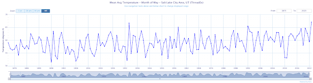
In the previous post, I commented about the Goldilocks temperatures over the past two weeks.  In my view, they were ideal for avoiding the use of home heating or cooling.   That said, they were not Goldilocks from a climate perspective. In fact, this May is going to go down as the warmest on record at Salt Lake City.  With one day left to go (today), the average temperature for the month is an incredible 67.1˚F.  That eclipses the prior record set in 1934 of 66.7˚F.   Source: https://xmacis.rcc-acis.org/ The 67.1˚F will likely go up a bit more today. I actually found this a bit surprising because there hasn't been any exceptional heat.  However, May has been characterized by relatively little variability in large-scale weather systems compared to normal.  Instead we've simply had sustained warmth.  In the plot below, the range of "normal" (i.e., averages for 1991–2020) is indicated by the green background.  This May, we had onl...

Goldilocks Temperatures with Thunderstorms

Image
Since about May 12th, we've been locked into what I'll call the large-scale doldrums with relatively weak flow at upper levels and a lack of strong synoptic systems and fronts.  The average 500-mb height analysis for May 12 to May 27 shows the pattern that has predominated quite well with a long-wave trough over the central Pacific, ridge over western North America, and trough over the Canadian maritimes.   Image source: NOAA/PSL At the same time, the pattern over Utah and indeed a good chunk of Nevada and the Sierra Nevada has been quite active from a thunderstorm perspective.  The reason for this is the weak short-wave trough that is embedded in the long-wave ridge (indicated by the dashed line above).  Systems have moved through this trough, modulating thunderstorm coverage and intensity, but it has refused to go away.   As a result, we've seen lightning and thunder on a regular basis in the Salt Lake Valley.  Other than that, there hasn't been...

Great Salt Lake Update

Image
The Great Salt Lake at Saltair* rose 4.7 feet from 4188.7 feet on October 1st of last year to 4,193.4 feet on May 1st of this year.  That's a big increase, but it is still very low.  The graph below illustrates the lake elevations at Saltair based on data from the USGS.  The orange line indicates the 4193.4 ft level, showing that the current elevation is still below all but the low stand in the early 1960s, recent seasonal minimums in the fall, and the drawn out low period of the past couple of years.   Lake elevation at Saltair since 1847 (USGS data) You may have noticed the asterisk above.  Saltair provides long-term records for the south arm of the lake, but the rock-fill railroad causeway dividing the lake in half can cause elevation imbalances.  Additionally, the berm in a gap in the causeway was raised recently.  As a result, while the south arm receives most of the freshwater runoff and has risen a lot, the north arm has only climbed slight...

That's a Wrap

Image
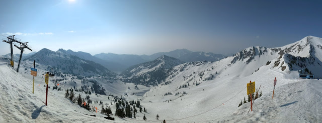
It's never over until it's over, but yesterday was probably my last day of resort skiing for the season.   It was an unusual last day, with smoked filled skies from the Canadian wildfires.   Friday night lows at the top of Hidden Peak were only 39˚F, yet there was a solid freeze of the snow on the mountain thanks to clear skies and long-wave radiative cooling.  Regulator was "not recommended" first thing and I can confirm that the ski patrol was on point.  With early sun, Mineral offered up soft skiing quickly due to its easterly and southerly exposures, but I'm always happier when the steeper lines off the tram can be skied.  North Chute and the like with May morning sun exposure began to soften up and ski well around 10:30.   It will be interesting to see if Snowbird can make July.  There is still an enormous amount of snow on the upper mountain.  Water equivalent at the SNOTEl site, although now well below where we were in 2010/1...

Great Salt Lake Bed Dust

Image
 Yesterday evening, while out for a walk, I noticed a wall of dust over the western Salt Lake Valley.   After returning home, I took a look at a video from the west-facing camera my department operates at the University of Utah and it showed a remarkable plume originating to the north and presumably from the exposed Great Salt Lake bed in what used to be Farmington Bay. Video from @UUtah @UofUATMOS showing considerable dust blowing into Salt Lake Valley apparently from exposed Great Salt Lake bed pic.twitter.com/paL8HoHTwd — Jim Steenburgh (@ProfessorPowder) May 18, 2023 Much has been made about the snowpack, runoff, and rise of the lake.  Indeed, the lake elevation at Saltair Boat Harbor has increased over 4 feet from its record low last fall.  It currently sits at about 4193.3 feet, but that is still remarkably low as can be seen by the elevation graph below for the past 40 years.   As a result, the lake area remains low and lake-bed is still expos...

The Big Melt

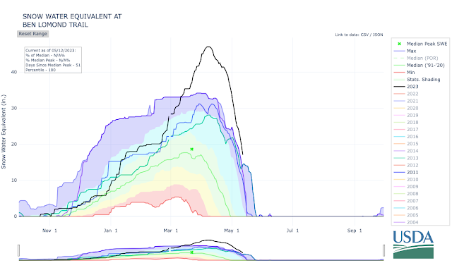
Image
Snow is melting and the decline in lower-to-mid elevation snowpack has been impressive.   The lowest SNOTEL in the Wasatch Range is Ben Lomond Trail in the northern Wasatch (5972').  Snowpack water equivalent has dropped like a stone there from its all-time 47" peak (with records going back to 1981) to 17.1 inches yesterday.  It remains at an all-time high, ahead of 2011, 1984, and 1983.  Based on the forecast, I suspect it will probably make it about another 10 days before becoming snow free. Source: NRCS In City Creek Canyon, the low-elevation Louis Meadow site (6700') has also seen an incredible decline from 43.3 to 13.1 inches.  It's now behind where the snowpack was in 2010/11.   Source: NRCS A bit higher on Lookout Peak (8161'), the big melt has just begun and has been slower.  Although now behind the 2010/11 snowpack, 45" of water remains.  Streamflows in City Creek are forecast to increase in the coming days as this upper-elevati...