Wednesday, November 9, 2022

The White Wave Wins!

So much talk about a red or blue wave last night, when it was really a great white wave that won.  The numbers from Alta are very impressive and means a climatologically deep early season snowpack will control upper elevations of the central Wasatch for the next few weeks.

Let's talk some numbers.  The storm-total SWE and snowfall at Alta-Collins (so far) are 3.38" and 24" respectively.  The 24-hour and 12-hour SWE for the period ending at 6 AM this morning was 3.06" and the 12-h total for the period ending at 6 AM were 3.06" and 1.99".  These are big water totals at the upper ends of what happens at Alta during the winter.  

Observations from the last 24 hours also show a peak hourly SWE of 0.40" (I consider anything above 0.30" to be exceptionally heavy snowfall), which was accompanied by a 4" increase in snow depth on the interval board, and .86" in 3 hours.  

Source: MesoWest

This snow was mostly high-density base builder.  The mean water content of the storm so far is about 15%.  Temperatures did not decline below 29˚F at Alta-Collins until after 3 AM, so I suspect nearly the entire period featured Cascade Concrete.  

Total snow depth at Alta Collins is currently 56".  This is probably the 2nd most on this date in at least 30 years.  On November 9, 2004, the snow depth at Alta Collins was 59".  That year was the best early snowpack since 1990 at the Snowbird SNOTEL site (more on this below).  

It's harder to tell how the low and mid elevations fared.  Yesterday's cold front stalled between Salt Lake and Park City.  Some of the cold air bled into the Cottonwoods for a while yesterday to help keep snow levels lower than I expected, but on the Park City side it remained warm.  For example, at the Powerhouse observing site in lower Little Cottonwood Canyon (6049 ft), temperatures dropped to 32˚F early yesterday morning with the passage of the front and onset of precipitation, but slowly climbed through 1 AM this morning.  I suspect this site saw rain or mixed rain and snow yesterday afternoon through 1 AM, but a change over to snow this morning.  

Source: MesoWest

In contrast, the yesterday's cold front never made it to Park City.  Thus, temperatures at the UDOT SR-224 observing site, which at 6697 feet is several hundred feet higher than the Powerhouse site in Little Cottonwood, were near or above 38˚F for most of yesterday and last night, only dropping to 32˚F after about 3 AM this morning.  

Source: MesoWest

Thus, I suspect this was mainly a rain event below about 8000 feet on the Wasatch Back, although the totals at upper elevations even on the Park City Ridgeline should be pretty solid.  

Finally, we have the SNOTEL data from Snowbird.  As of midnight last night, the snowpack water equivalent was 9 inches.  This is the 2nd highest since 1990, behind only November 9, 2004 when it was 12.1 inches.  

Source: NRCS

The bottom line is that no matter how the election count turns out, we remain a deeply divided country.  However, the white wave has taken over the central Wasatch and we have the 2nd best early season snowpack since 1990.  So, regardless of where you fall on the political spectrum, there are good reasons to celebrate.  What an amazing start to the ski season!

Tuesday, November 8, 2022

Early November Storm of Our Dreams

Mother Nature is serving appetizers this morning before the main course tonight and tomorrow in the form that I can only describe as an Early November Storm of Our Dreams.  

The surface cold front moved into the Salt Lake Valley last night, passing over the University of Utah at about 0530 MST this morning and producing a rapid drop in temperature.  Temperatures have subsequently fallen into the high 30s.  

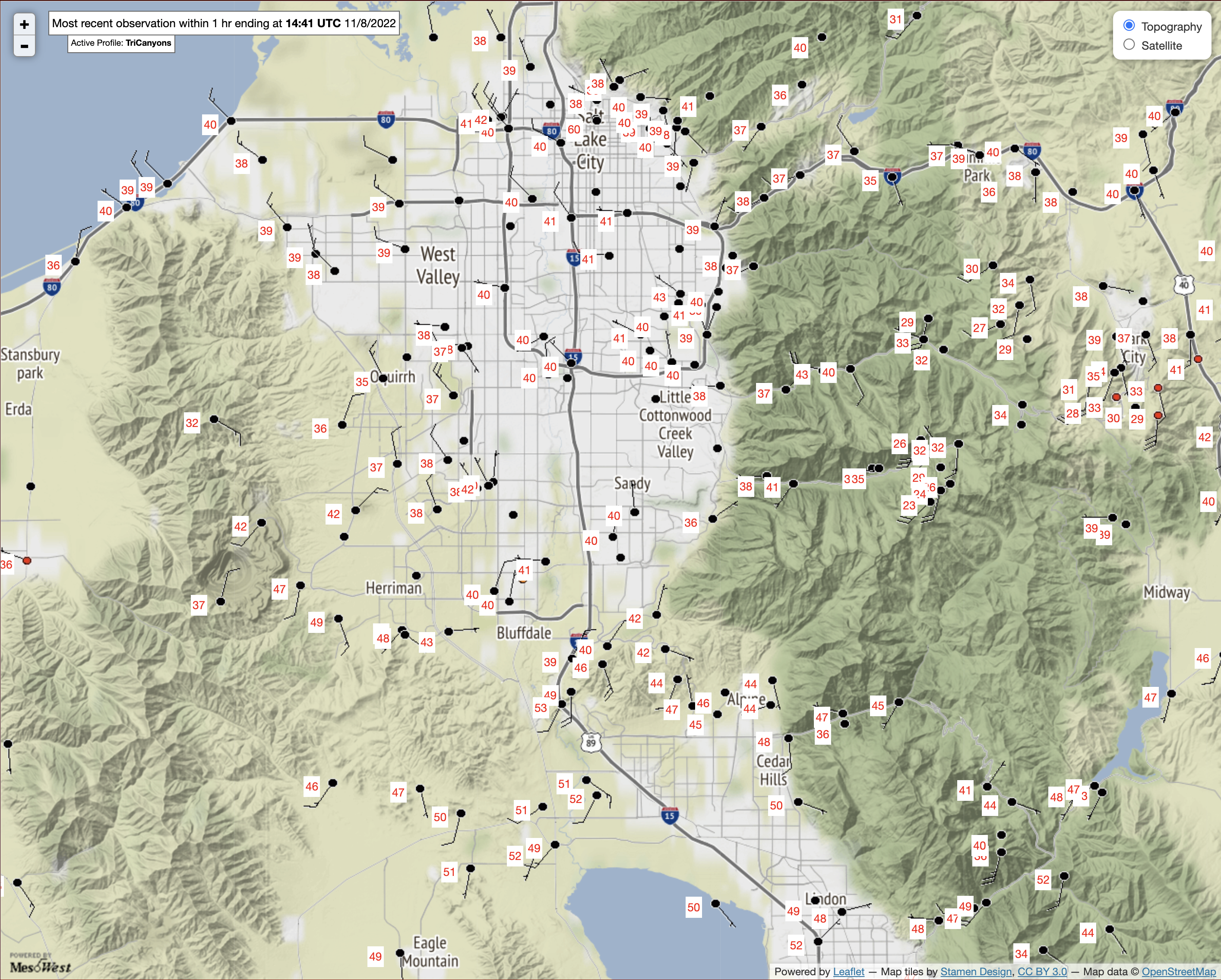
As of 1441 UTC (0741 MST) this morning the front was very near Point of the Mountain with north winds and temps near 40 in Bluffdale and Draper, but southerly flow and temps near 50 around Point of the Mountain and Saratoga Springs.  Crest-level winds in the central Wasatch remain southerly or southwesterly on Hidden Peak, Mt. Baldy, Cardiff Peak, and Reynolds Peak.  The front has not arrived in the central Wasatch, so snow levels remain high.  It is 32–35˚F at observing sites near the base of Alta for example. 


Radar imagery at 1440 UTC (0740 MST) shows scattered precipitation, in some areas heavy (e.g., southeast Salt Lake Valley and western Central Wasatch. 


Nearly all of these precipitation features are moving from southwest to northeast as the cold-front is shallow and the primary driver of precipitation processes remains the southwesterly flow aloft.  

Observations from Alta-Collins shows fits and starts of precipitation overnight, increasing in intensity after about 0500 MST.  In the hour ending at 0700 MST, 0.17" of water equivalent fell, and a total of 0.32" has fallen since midnight.  Temperatures at this 9662 ft observing site are mild and are now around 29˚F.  


We recently installed a profiling radar system at the Atwater site near the base of Alta.  This is a radar that looks up through the storm, rather than scanning horizontally. Overnight, Echoes were first detected aloft at 0400 UTC (2100 MST) and reached the ground at about 0600 UTC (2300 MST).  The pulse-like nature of the echoes through 1430 UTC (0730 MST) is consistent with convective showers, which were probably in the form of wet snow and graupel at the observing site and even to upper elevations.  


The forecast for today is essentially a WYSIWYG forecast, meaning What You See Is What You Get.  The 12Z HRRR for example, stalls the front pretty much near it's current location near Point of the Mountain with northerly flow over the Salt Lake Valley at 2200 UTC (1500 MST), southerly flow near Point of the Mountain, and southerly to south-southwesterly flow over the Central Wasatch.  

The HRRR also produces periods of showers in the southwesterly upper level flow, sometimes heavy, in the form of upper elevation snow and lower elevation rain through the day today.  The other models are in general agreement with this.  If you are skiing today, hard shell recommended as the snow level will be in the 7000-8000 ft range and above that the snow will be wet.  Note that thunder and lightning are possible with stronger showers.  

Things change overnight.  I added time-height sections for the HRRR to weather.utah.edu yesterday [under the HRRR (48 h) tab] so I'll used it here to illustrate what is expected.  Overnight, a deeper cold front pushes into the Salt Lake Valley at around 0800 UTC (0100 MST).  Ahead of this front, the southerlies intensify so we will see return to southerly flow in the Salt Lake Valley.  Additionally, this isn't one of those northwesterly cold surges.  The flow behind the front shifts briefly only slightly and the flow aloft gradually veers from southerly to westerly over a several hour period.  


However, the models are generally locked in on the front being accompanied by heavy precipitation.  The have actually been advertising this for days, although amounts have been variable.  The HRRR composite reflectivity and satellite imagery forecast for the time of frontal passage [0800 UTC (0100 MST) tonight] shows the band of heavy precipitation extending from St. George to Salt Lake City.  

Precipitation continues overnight in the wake of the front. Although there could be a break during the day tomorrow, convective showers develop in the deep cold air that moves in tomorrow afternoon.  


Let's look at some numbers.  From 1200 UTC (0500 MST) this morning (Tuesday) through 1200 UTC (0500 MST) Thursday, the HRRR generates 2.09" of water equivalent at Alta-Collins. Given the southwesterly flow, it's even more excited for Sundance, Snowbasin, and Powder Mountain, although those resorts will probably see rain at their bases today.  Most of this falls through mid-morning tomorrow (Wednesday).

The GFS numbers are pretty similar.  The GFS totals below, however, include precipitation overnight, but at least for Alta-Collins the GFS didn't produce any precipitation overnight, so from 1200 UTC (0500 MST) this morning (Tuesday) through 1200 UTC (0500 MST) Thursday, the GFS is generating 2.4" at that site. 
Our GFS-derived guidance product shows very well the situation today with a high wet-bulb zero level (and snow level) today that crashes down overnight when the front moves in.  Snow-to-liquid ratios are near 10:1 today but increase to 15"1 overnight.  I suspect the former is too high and we will see even higher densities than that. 

 
The 2.46" of water equates to 26.1" of snow based on our algorithms.  Most of this falls by 10 am tomorrow with dribs and drabs after that.  The increase in snow-to-liquid ratio during the storm indicates that although the average density will be high, it will be a right-side-up storm, although avy danger is likely to be an issue.  

My take on this is we are probably going to see storm totals at Alta Collins from last night through Thursday morning in the 2-3" range for water equivalent and 20–30" for snowfall.  The lower elevations will suffer today, but get a decent shot once the front comes in tonight.  The NWS is even more excited, going for 2.5–3.5" of water (although their 18–32" of snow brackets my 20–30").  

NWS Cottonwood Canyons Forecast screenshot at 8:32 AM 8 November 2022

What can I say?  This is a dream early November storm for building a seasonal snowpack.  

Monday, November 7, 2022

Buckle Up

 Red sky at morning sailors take warning?


Actually, the sky looked sort of purple today, as if I woke up in Mordor.  I knew something was up when I woke in the night and the house was shaking.  Indeed it was an impressively windy night in the lowlands with several sites reporting gusts of 60 mph or more including 68 mph near Point of the Mountain and 65 at the intersection of I-80 and SR-201 in the Salt Lake Valley.  

The instigator of this big blow is a deep upper-level trough that is amplifying off the Pacific coast.  The interaction of this feature with the Sierra Nevada is resulting in the development of low pressure over the Great Basin and a strong pressure gradient over western Utah.  

I'm a little surprised it blew so hard last night based solely on the large-scale analyses, suggesting something else is happening, but my time is limited for proper sleuthing and I'm more interested in the potential for snow.  

The upper-level trough note above, along with surface features that develop over the Great Basin as that trough digs off the west coast and eventually moves eastward, will dominate our weather over the next few days.  

Today in the Salt Lake Valley it will be dry, warm, and windy.  In the central Wasatch, there could be a few angry fits and starts of snow, but if it happens, it will only be enough to lacerate your face.  

A sharp surface trough and frontal boundary will develop just to our north (annotated on the upper-right hand image below).  This is a common occurrence as an upper-level trough digs off the west coast.  By 0600 UTC 8 Nov (11 PM MST Monday), the frontal boundary is just to our north, which is why we are likely to remain dry despite the fact that weak atmospheric river conditions extend over our area (lower right). 

On Monday night and Tuesday morning, that frontal boundary sags southward and at 1800 UTC 8 November (11 AM Tuesday) it's located very near the Salt Lake City International Airport.  

It's such a close call that I'm not sure if the front and it's precipitation will make it into the Salt Lake Valley and the central Wasatch.  Right now the GFS is bringing it right to the Salt Lake City International Airport.  Below is a closeup at 1800 UTC 8 November (11 AM Tuesday) and the wind shift is perhaps just north of the airport with light precipitation extending eastward to the central Wasatch.  


Right now, this is a chance of valley showers, mountain snow showers situation for tomorrow, with snow levels near or around 7000 to 7500 feet.  We'll potentially get skunked if the front stays a bit north, or do better if it pushes a bit farther south.  

Things begin to light up, however, as the upper-level trough and associated surface low move inland.  Rain moves into northern Utah Tuesday night and by 1200 UTC 9 November (5 AM Wednesday) a band of heavy precipitation covers most of western and northern Utah.  


For that storm period, the GFS has been bouncing around the past several runs between 2 and 4 inches of snow water equivalent for Alta.  In the latest run from last night, it's putting out about 0.3" with the cold front on Tuesday and then about 1.45" with the main band on Tuesday night and Wednesday, followed by some more dribs and drabs Wednesday night.  


A glance at the Euro suggests it's a bit wetter.  For the entire period, the downscaled NAEFS is putting out an average of about 2.75 inches of water.  All but two members are above 1.5 inches.  


The bottom line is that this will be another major storm adding 1.5 inches of water or more to our upper-elevation snowpack in Little Cottonwood.  Perhaps we will take a closer look tomorrow if I can find the time. 

Sunday, November 6, 2022

The Formation of Drizzle and Freezing Drizzle

This post is dedicated to everyone who came out to break trail for me today.  So many people turned out.  Your dedication and efforts are greatly appreciated.  I need all the help I can get at my advanced age.  

If you happened to be one of those ski tourers in upper Little Cottonwood today, you may have experienced drizzle (below the freezing level) or freezing drizzle (above the freezing level).  Let's take a look at what these are and how they form.  

Drizzle is a form of liquid precipitation comprised of small water droplets.  Scientifically, drizzle droplets are larger than 100 nanometers and less than 0.5 mm in diameter.  If the droplets are smaller than 100 nanometers, they are cloud droplets.  If they are more than 0.5 mm they are rain droplets.  

Freezing drizzle is drizzle that freezes on impact with the ground or other objects.  It occurs when drizzle forms and collides with the ground or other objects at temperatures below 0˚C.  In such conditions, the drizzle drops are supercooled, meaning they exist as liquid water at temperatures below 0˚C. 

Somewhat related to freezing drizzle is rime, the white icy deposit when supercooled cloud or drizzle drops collide with the ground or other objects like trees, structures, or your goggles.  On my descent at about 1 PM, I used my thumb several times to scrape the rime off my googles that formed as I skied through the freezing drizzle.   

Drizzle or freezing drizzle typically forms in shallow stratocumulus or altocumulus clouds.  A few large droplets form typically near cloud top, turbulence allows them to collide and merge with other droplets, and grow into drizzle drops that can fall out of the cloud.  The process of droplets colliding and merging is called collision-coalescence.  This can occur in clouds that are entirely above freezing (i.e., > 0˚C) or in clouds that have temperatures reaching as low as about -10˚C.  In the case of the latter, freezing drizzle occurs at altitudes where temperatures are at or below 0˚C.  

Critical for the formation of freezing drizzle is the existence of supercooled water droplets.  These supercooled water droplets can exist because water does not necessarily freeze at or below "freezing."  Between -40˚C and 0˚C water needs what is known as an ice nucleus or ice nucleating particle to catalyze the ice formation process.  Ice nucleating particles include some forms of clay and some types of bacteria.  For instance, snowmakers often use an additive known as Snowmax, a microbe that helps water freeze.   Just below 0˚C, water needs a particle with a structure very similar to ice to freeze.  But as the temperature decreases, a greater diversity of particles can initiate freezing.  At -40˚C, water will freeze whether or not it has an ice nucleating particle.  

Getting water to freeze in a puddle or a lake isn't a problem because there are all sorts of particles in a large volume of water to initiate freezing.  But in a tiny cloud droplet, the odds it contains an ice nucleating particle is very very low, especially at temperatures just below 0˚C.  

I think the freezing drizzle produced this afternoon in upper Little Cottonwood was produced in relatively shallow clouds that were draped over upper-elevation ridges.  You can see these shallow clouds in upper Albion Basin.  Note that they appear to be somewhat decoupled from the higher clouds aloft.  

I noticed the drizzle around 1 PM. At that time, temperatures at 10,500 feet within those clouds were around -4˚C.  At such temperatures, there are very few ice nucleating particles.  Most of the cloud droplets are supercooled and with a little turbulence, one can develop freezing drizzle.  

If, however, the clouds extend to altitudes where temperatures are near or below -10˚C, there are usually enough ice nucleating particles to freeze some of the water droplets.  When this happens, some of those droplets will shatter as they freeze, producing many ice particles.  This process is known as ice multiplication and it allows the cloud with cloud top temperatures below -10˚C to contain a stew of ice and supercooled liquid water particles.  Typically in such a cloud, the ice particles grow more rapidly than the cloud droplets (I'll avoid talking about why this occurs as this is already a long post) and this short-circuits the drizzle formation process.  You either don't get any precipitation or you get snow.

A curious aspect of our tour today is that it was snowing when we arrived at about 9:15, so something changed between then and about 1 PM when the freezing drizzle formed.  One possibility is that at 9:15, the cloud was deeper, with cloud top temperatures below -10˚C, or the snow was being produced in a cloud layer aloft and falling through the lower clouds.  I don't have sufficient observations to evaluate these hypotheses.  Often our routine weather observations do not allow us to adequately probe the mysteries of cloud microphysical processes.  

Friday, November 4, 2022

How about Something Different

Mother Nature has been generous so far this year with 50" of snow so far at Alta and the Snowbird SNOTEL station up to a very solid 5" of snowpack water equivalent.  Skiing conditions yesterday were very good.  A few people elected to get out.  

Most of the snow we've received so far this season has been produced by slow moving or stalled cold fronts or cold, postfrontal flows.  That will change with our next system.   

Below is the GFS forecast valid 1800 UTC 5 November (1200 MDT Saturday).  Strong west-northwesterly upper-level flow extends from the eastern Pacific across the Pacific Northwest to northern Utah (upper left panel).  Strong (by interior western US standards) water vapor transport extends inland across the northern Great Basin into northern Utah (lower right) with moist, westerly flow at crest level (lower left).  700-mb temperatures (lower left) are fairly mild and near -3.5˚C.  Forecast precipitation along a weak surface trough that will sag through northern Utah Saturday night extends across southern Idaho. 

The time height section through 6Z 6 November (midnight Sunday) shows the gradual descent of an elevated warm front today through tonight.  By 1200 UTC 5 November (6 AM MDT Saturday), relative humidities except near the surface are generally at or above 90% through a deep layer.  During the day tomorrow, the valley flow will be southerly to southeasterly, but westerly aloft.  Eventually low-level winds shift to northwesterly after 0000 UTC 6 Nov (6 PM MDT Saturday) as the GFS sags the trough slowly southward through northern Utah.  

Basically, this is a recipe for a warm, windy storm in the mountains and virga with occasional rain showers in the Salt Lake Valley Saturday and Saturday night, with precipitation rates likely greatest during the approach and passage of the trough.  

There are, however, model disagreements on the timing and productivity of the storm.  The 12Z HRRR is going off and shows strong enhancement of water-equivalent precipitation over the Wasatch through 1200 UTC 6 November (5 AM MST Sunday - note local time change)  with 0.69" at KSLC, 0.73" at Cottonwood Heights, and 2.71" at Alta-Collins.  Some big numbers are also evident in the northern and southern Wasatch.  Most of this precipitation falls Saturday and Saturday night. 

The global models are, however, a little less enthused for the central Wasatch.  The GFS generates 0.94" and ECMWF about 0.93" for Alta-Collins for that same period.  The ECMWF is also slower with things picking up later on Saturday. 

The models do agree this will be a warm storm.  Below are some numbers from our GFS-derived forecast for Little Cottonwood Canyon.  The wet-bulb zero level on Saturday rises from as low as 6100 feet at 11 AM to 7900 ft at 7 PM before dropping Saturday night. 


The snow level is typically a bit below the wet bulb zero level, but this is a recipe for high-density, possibly upside-down snow on Saturday and Saturday night before things cool off Saturday night after the trough passage.  Our algorithms suggest snow-to-liquid ratios on Saturday and Saturday evening of 8 or 9 to 1 (water contents of 11 to 12%).  I would not be surprised if the density was higher than that.  

Bottom line is that we are looking at a base-building snow event at upper elevations and a bit of a mess near and below 7000 feet with precipitation type varying.  For Alta-Collins, I would probably not go all in on the HRRR forecast.  I can't rule it out, but something like 1-1.5"of water and 8-16" of snow through Sunday morning is probably more likely (the NWS is going for 0.9 to 1.25" and 10–16").   

Tuesday, November 1, 2022

Ten-Day Snow Potential

The next ten days have tremendous potential to transform the early season skiing potential in the central Wasatch Mountains.  

We've already been blessed with a good October. The Snowbird SNOTEL sits at 3.9" of snowpack water equivalent, which is 390% of median. The warmth of the past few days has caused some snow losses on south and west facing slopes, but has also probably limited depth-hoar formation, which may help us stave off a persistent weak layer (note that I was not in the field yesterday or today so this is not an observation and it does not mean that surface facets, near surface facets, or other weak layers could prove problematic when the snow begins tomorrow).  

A best-case scenario now is for the snowpack to deepen, opening more terrain for touring and giving us some additional insurance against depth-hoar formation.  

Tomorrow is looking good.  A cold front is expected to stall over northern Utah, giving the central Wasatch a prolonged period of snow.  The situation at 1500 UTC 2 November (9 AM Wednesday) shows the 700-mb temperature contrast associated with the cold front parked right over the Central Wasatch.  Additionally, the flow in this area is confluent, with 700-mb (about 10,000 ft) inflow between south-southwesterly flow over southeast Utah and west-southwesterly flow over northwest Utah aligned right along the front and temperature contours (see lower left).  

Such a pattern is what meteorologists call frontogenetical, as it acts to strengthen the front.  Additionally, the vertical circulations associated with such a frontogenetical pattern are often favorable for precipitation, and the GFS both stalls the front and strengthens the associated precipitation during the day tomorrow.  


By 0600 UTC 3 Nov, the GFS has laid down just over 1" of water equivalent in the upper elevations of the central Wasatch.  

The GFS terrain is smooth, so it does not capture some of the fine-scale characteristics of precipitation in the central Wasatch.  I have noticed that it often produces more snow at the Park City resorts than Alta (as is the case above), even though that is typically not the case.  The Euro is also near or just over an inch through 0600 UTC 3 Nov near or just east of the Wasatch Crest.  

On the other hand, the HRRR has better terrain representation and puts out 1.33" at Ala Collins, 1.1" for Canyons-Daybreak, and 0.76" for Deer Valley-Ontario.  

There is some potential for orographic or lake-effect snow continuing Wednesday night and Thursday.  Right now, the flow directions and depth of the instability being advertised by the models are such that I don't expect this to be a major accumulation period for the central Wasatch, but that could change if the flow direction shifts. 

The latest 12Z GFS-Derived Little Cottonwood forecast just came in as I type this and it is consistent with the forecast above.  About an inch of mostly frontal precipitation (water equivalent) through  midnight Thursday and then a bit more through early Thursday morning and Thursday during the day.  


Applying our snow-to-liquid ratio algorithms to that gives about 13" of snow through midnight Thursday and 17" by Thursday night.

Based on these forecasts, I expect 10-18" of snow at Alta Collins by midnight Thursday and then perhaps another 3-6" after that through the Thursday afternoon.  

The forecast beyond that is also optimistic.  Through 5 PM next Tuesday, another 1.25 inches of water in the GFS.  Other models vary, but overall the pattern is one in which I expect to see more added to the snowpack.

Remember that the resorts are de facto backcountry right now.  Avalanche conditions will be changing dramatically tomorrow.  Let's be careful out there.