The upper-level pattern is locked in for the for the foreseeable future.
Below is a 12-day loop of GFS analyses and forecasts from 1200 UTC (5 AM MST Tuesday) 11 January through 1200 UTC (5 AM MST Sunday) 23 January. Color fill is the wind speed at jet-stream level (250 mb). The Pacific jet is raging, extending from Asia across the western and central Pacific. Apologies for not including a color scale, but at times maximum winds along the jet core locally exceed 200 knots. What a beast.
However, the jet splits near through this period near Hawaii. There are some variations in the extension of the jet, but for the most part, Intermountain West is left under a ridge or split flow with just some synoptic debris, or weak troughs floating around. These are the leftovers spit out from the exit of the Pacific Jet.
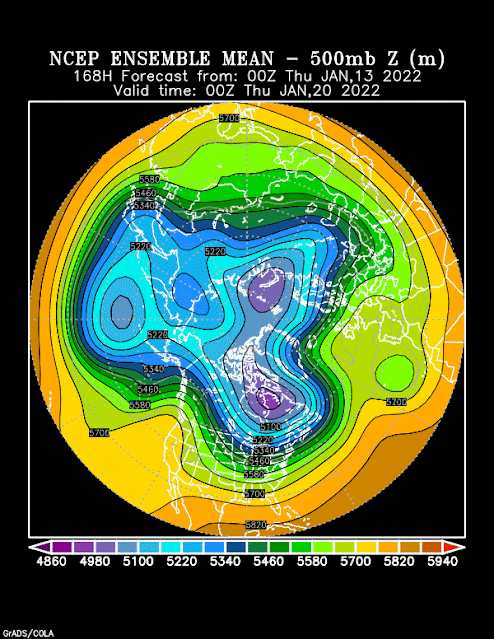
Let's take a look at some ensemble forecasts. Below is the mean 500-mb geopotential height forecast from the Global Ensemble Forecast System valid 0000 UTC 20 January. The upper-level flow generally parallels these contours and is strongest where the contours are close together. Here you see a deep trough over the north Pacific, the raging Pacific Jet, ridge over the west coast of North America, deep trough over eastern North America, and ridge over the North Atlantic. Commit that to memory.
 |
| Source: NOAA/ESRL/PSD |
Same, but for 0000 UTC 23 January. Same pattern, but more amplified.
 |
| Source: NOAA/ESRL/PSD |
Same, but for 0000 UTC 28 January. A little flow here cutting under the ridge over the western U.S. Otherwise not much change.
Basically, the pattern is locked, but for Utah not loaded. The upper-level/jet stream pattern is very high amplitude with persistent upper-level troughs and ridges remaining relatively stationary. For snow, we have to hope for an upstream shift in the upper-level ridge so that some of the storms moving over it can drop down into our area or for the southern branch of the split jet to get more active and extend into our region. There's also the hope that the models are wrong. There's always hope.
Right now, it looks like the odds are stacked for below-average snowfall for the next 14 days. Worst case scenario is little to no snow. Best case scenario is something can slip through the net as described above and we get a couple of modest storms. Tonight and early tomorrow we have one of those troughs that moves over the ridge, but the moisture is scant and too far north, so other than some flurries in the mountains, we won't see much, although it will fortunately stir up the inversion and the pollution, although it's not clear if we will see a full or partial mix out. Hoping for the former, but will take the latter. Beggars can't be choosers.


No comments:
Post a Comment