Quite a mess of a storm right now over northern Utah. I'm not sure where to start, but maybe a look at some of the observations is a good place.
Easterly flow extends from southwest Wyoming to the northern Wasatch Front where strong downslope winds persist from the area around Parleys Canyon northward. One can also find strong easterlies in local canyons further south, such as Provo Canyon. In the western Salt Lake Valley and along the US-40 in the Wasatch Back, the flow is northerly. The former reflects what we sometimes call the "Sandy Eddy", a counterclockwise circulation that often forms over the Salt Lake Valley during downslope windstorms and is centered near Sandy.
 |
| Source: MesoWest |
A look at the flow on Hidden Peak and Mount Baldy in the central Wasatch, however, shows southerly flow. Indeed, the sounding from the Salt Lake City airport this morning is simply amazing.
 |
| Source: SPC |
The surface flow out at the surface was actually light and from the northwest, with a layer of strong easterlies between about 800 and 750 mb. This might seem odd, but often during downslope windstorms there is a hydraulic jump downstream of the mountains where the strong easterly flow becomes elevated, with a rotor beneath with reversed flow at the surface.
 |
| Source: Whiteman (2000) |
This appears to be the case at the Salt Lake City airport. Not the sort of thing that you want for air travel as rotors often are associated with strong turbulence.
Above the easterlies, the flow veers (turns clockwise) rapidly with height to south southwesterly. There's also a sharp inversion, which marks the top of the cooler air from the east.
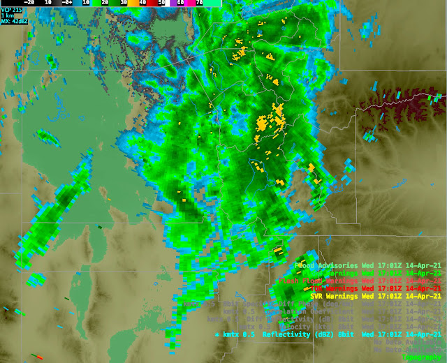
Satellite imagery shows the counter clockwise circulation around the upper-level low that is centered over western Nevada. We are in the south-southwesterly flow ahead of the upper-level low. Note that despite the easterly flow at the surface in many areas, all of the clouds are being generated in the south-southwesterly flow aloft. In addition, there are two major cloud bands, one over western Utah and one over central Utah.
 |
| College of DuPage |
Finally, if we turn to radar, we see that each of those bands is associated with precipitation.
Automated snow depth sensors this morning show overnight accumulations in the central Wasatch through 7 AM this morning of about 2 inches at both Solitude Summit and Alta-Collins. The interval sensor at Canyons-Daybreak appears to be down, but the total snow depth has ticked up a bit over 2 inches , so let's call it about 2 inches in the central Wasatch through 7 am.
The model guidance this morning continues to be a head scratcher. The latest HRRR has the eastern-most band decaying this morning, while the westernmost persists.
It then fires up some more precipitation with surface heating and the approach of an upper-level front around noon.
And then scattered showers (and thunderstorms perhaps) this afternoon.
It's pretty clear from radar that the eastern band is going to persist longer than advertised by the HRRR, but how long I'm not sure.
The GFS has the heaviest heavy precipitation west of the central Wasatch (and in the current dry slot) this morning, then jumps it to east of the Wasatch this afternoon.
However, it keeps the central Wasatch in precipitation for the period. Nevertheless, the 0600 UTC initialized GFS numbers for 1200 UTC (6 AM MDT) today through 1200 UTC (6 AM MDT) Thursday are lower than yesterday's 0600 UTC run discussed in the previous post. It's putting out 0.70" of water and 8.1" of snow for Alta-Collins.
Finally we have the SREF. Through 1200 UTC (6 AM MDT) Thursday it is producing a mean of about 6" at Alta-Collis and a range of 2.5 to 10 inches.
My best guess 6-12 inches for Alta-Collins from for 1200 UTC (6 AM MDT) today through 1200 UTC (6 AM MDT) Thursday, with a good chunk of that coming today. The snow may come in waves as band position changes or the showers become scattered. It's worth noting that thunderstorms are a possibility you should move inside or into your car if this occurs.


