
Today is one of those days when I look at the observations coming in and I keep redoing the math in my head and asking myself if I'm doing it wrong. The numbers from the Sierra Nevada near Mono Lake are ASTOUNDING.
For much of the night and day, that area has been in the crosshairs of an atmospheric river and slow moving frontal precipitation band. Below is the synoptic situation as of 2100 UTC (1400 MST) showing heavy precipitation over central California in the southwesterly flow ahead of the upper-level trough (note that portions of the Sierra have poor radar coverage.

Twenty-four hour snow depth change diagnosed from automated sensors shows the heaviest snowfall in the eastern Sierra near and around Mono Lake, including an increase of more than 20 inches at one site. Most of this snow has fallen in a period of about 15 hours (ignore the 39 near Lake Tahoe which may be eroneous).

Not shown here are observations from Mount Rose in the Carson Range near Lake Tahoe which also got more than 18 inches last night.
Those are changes in total snow depth. That's a bit different than new snow which is ideally measured on a board that is wiped between 1 and 4 times a day. The Sesame Observing site at Mammoth Mountain is their equivalent of Alta-Collins here in the Wasatch (they also have a remarkable snow-energy balance station elsewhere on the mountain with great data). The trace below from their interval board shows 16 inches from 2200-0500 PST when the board was wiped, followed by another 18 inches.
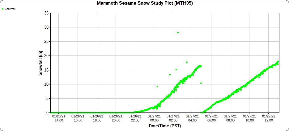
That adds up to 34 inches in 13 hours.
Try saying that five times fast.
And this storm is just getting started.
No comments:
Post a Comment