
The three most important things in real estate are location, location, and location, and that's often the case for winter storms in northern Utah. The position of precipitation systems can make or break the forecast at a given location, and that's the case for the Friday-Saturday storm that we've been hoping for over the past several days.
The storm has at least two parts and possibly more depending on how things come together. Due to scheduled downtime of the National Weather Service server that we get our model grids from, I'll be using the 1200 UTC NAM forecast from this (Thursday) morning to illustrate these parts.
The forecast for 1500 UTC 22 Feb (0800 MST Friday) shows a deep upper-level trough over the northern California coast. At this time, there's only spotty precipitation in the southwesterly flow over the southwest US, including Utah.

However, during the day tomorrow, due to the strong dynamics associated with the trough, things moisten up nicely and precipitation develops across much (but not all of Utah) by 0000 UTC 23 Jan (1700 MST Friday).

This moist, southwesterly flow is the first storm part. Any precipitation in the Salt Lake Valley will be rain Friday afternoon, with snow levels potentially reaching as high as 6500 feet, before they lower Friday evening and Friday night, reaching the valley floor early Saturday morning.
The second storm part forms along the surface and low-level trough axis further to the northwest on Friday night, evident as an area of heavy precipitation northwest of Salt Lake City at 1800 UTC (11 AM) Saturday in the NAM forecast below.

The flies in the ointment concern the potential to be "dry slotted" between the moist southwesterly flow period and when that band moves through, as well as the precipitation pattern and intensity associated with that band. A best case scenario is everything produces and the mountains see a great deal of snow. A worst case scenario is the storm comes through in fits and starts and accumulations are more limited.
These features can be seen in the NAM time-height section below. From late Friday through about 6Z Saturday (2300 MST Friday) low-level relative humidity is high and moisture is deep. After that, there's a period where things dry out and you can see a slot of dry air at mid levels Saturday morning (i.e., from about 12-18Z). Then the surface trough finally comes through after 0Z Sunday (1700 MST Saturday).

Because of the server downtime, I'm using an old SREF as well. The plume below is for Alta and shows a mean of about 13 inches and a range from about 5 inches to 26 inches.
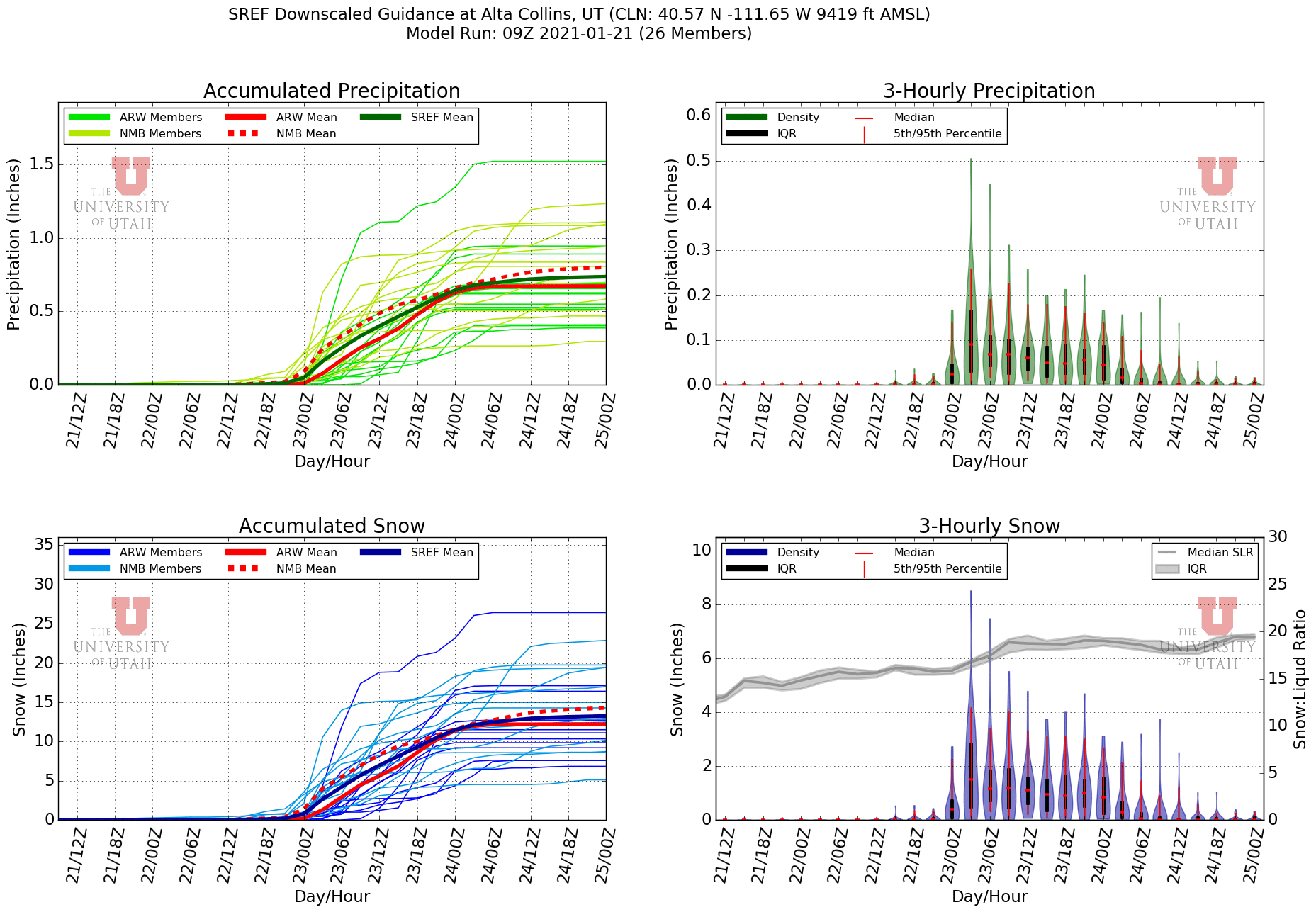
Most members fall between about 7 and 15 inches. By and large, this should be a decent storm and I would lean toward a 10-20" storm total for the upper Cottonwoods. This could come in pieces though, beginning Friday afternoon and ending Sunday morning. More than 20" will require one of the pieces to come through big time, or for the event to be more continuous.
I haven't given much thought for Mountain Dell or Round Valley, so I'm just going to be burning skis and praying to Ullr that they get snow too.
No comments:
Post a Comment