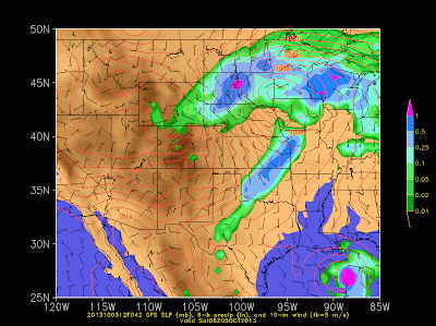
Again, I am remiss today in ignoring the weather for later today and tonight in northern Utah, but in addition to the potential impact of Karen on the Gulf states discussed in the previous post, we have a truly remarkable winter storm set to rumble across Wyoming and the Dakotas, with blizzard conditions expected in some areas. The storm will start with rain in some areas, but most of Wyoming and the Dakotas will eventually see snow as colder air moves in and precipitation rates intensify. This is a very powerful early season storm with all the key ingredients for interstate gridlock and dangerous travel conditions:
- Strong lee cyclogenesis over eastern Colorado with cold high pressure to the north and northwest
- A strong intervening pressure gradient with strong surface winds across Wyoming and the Dakotas
- Heavy precipitation rates
Check out the GFS forecast for 0600 UTC (0000 MDT) 4 October through 0600 UTC (0000 MDT) 5 October. Yeah, those are some big precipitation totals with some very strong winds.
It's not going to feel like October 4th in this part of the world tomorrow. This is a very serious storm with winter storm conditions about as bad as they can get.


No comments:
Post a Comment