 |
| Early morning snow at Alta |
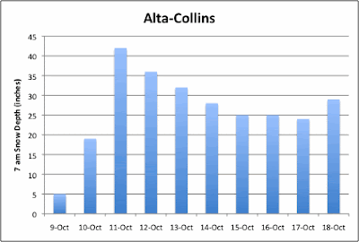
Notice, however, the uptick to 29 inches this morning. The dribs and drabs of wet snow yesterday and overnight are adding up. And it is high density base builder. Over the past 24 hours, Alta-Collins has observed 8 inches of snow with 1.16 inches of SWE. That's 14.5% water content. The Utah Avalanche Center suggests the storm is producing quite a bit of graupel. If it's white, it's good, and if it's graupel, better yet.


I thought graupel was bad to have? Or is that later on in the season near a weak layer as a sliding surface?
ReplyDeleteWow, I'm hoping this snow will stay around for Thanksgiving? I'm driving up to Alta from Phoenix, AZ where it was over 80 degrees today. I hope all the snow doesn't melt off in the next few days. I'd be ecstatic if all I had to ski on were some groomed blues that wouldn't destroy my skis. My standards are much lower than yours =)
ReplyDeleteI mean, it's either this, or Wolf Creek, which has just 15".