
Thus, critical to all forecasts is the use and interpretation of numerical weather prediction model output. Most forecasters use something called the forecast funnel to do this. The approach typically involves an assessment of the large scale atmospheric structure (such as the strength and movement of pressure systems and fronts) and then a funneling down through smaller scales until one is considering a very specific local forecast.

For a storm like the one expected this weekend, a forecaster examines data from several forecast models, such as the GFS, NAM, and ECMWF, as well as ensemble modeling systems like the SREF see Forecast Tools: The NCEP Models). Critical for this storm is the track and intensity of the upper-level trough digging down from the northwest and its interaction with the regional topography. Given that each of these models and ensemble modeling systems has differing strengths and weaknesses, all of them are typically consulted and considered.
Once the forecaster has a handle on the larger-scale flow and its interaction with the topography, they typically begin to look at smaller scales. We have some products on our Utah Weather Center web site that allows you to look specifically at what some of the models are predicting for upper Little Cottonwood Canyon. Some of this information comes directly from the model, such as QPF (this is the amount of precipitation in terms of snow water equivalent), while others such as snow ratio/water content and snow use algorithms developed by Alcott and Steenburgh (2010) applied to the model output. For instance, here is the forecast from the latest 12-km NAM (initialized at 1200 UTC this morning).
 |
| Source: http://weather.utah.edu/text/COTTONWOODS.txt |
Another way to look at this is graphically. You can find these plots on the Utah Weather Center if you click on the model of interest, then "meteogram", and then "Alta, UT."
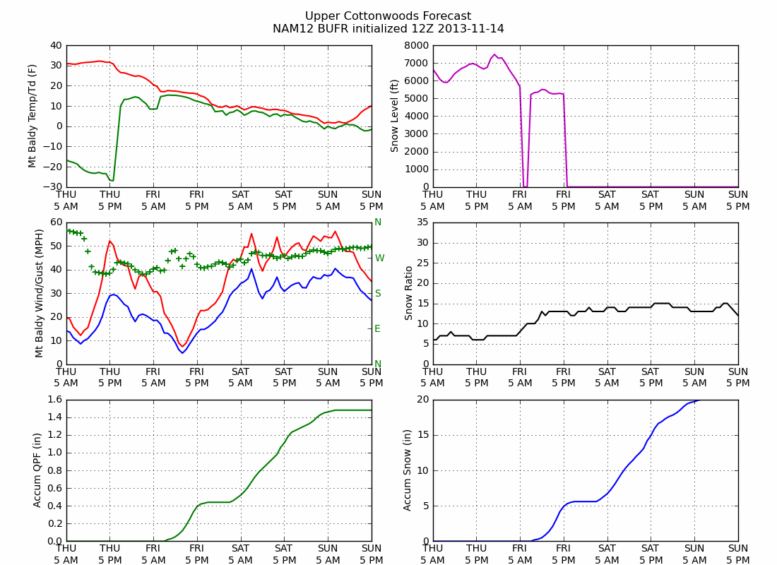 |
| Source: http://weather.utah.edu |
This spread is produced because the atmosphere is chaotic and because we use somewhat different techniques to simulate the atmosphere in these various models. When you see a forecast of say 10-20 inches, that reflects the most likely range of possibilities. Typically that range also reflects some analysis and assessment of the model output, such as giving more weight to a model that the forecaster feels has a better handle on the situation, or making adjustments based on past model performance and biases. Forecast confidence is typically larger for shorter range forecasts than for larger range forecasts, but some phenomenon, such as lake effect, are very difficult to predict even with lead times of a few hours.
So, in a situation like this, we see a storm coming, but there remains some uncertainty with regards to magnitude. My best guess for the most likely range is 10-16 inches for upper Little Cottonwood, which is comparable to the NWS forecast issued 3 am last night. This is lower than predicted by the 12-km NAM, which reflects my concern that the trough will move out fairly quickly, bringing a quicker end to the storm.
So that's some insight into the forecast process, as imprecise as it is.
No comments:
Post a Comment