Wednesday, January 31, 2024

Southern Track Goldilocks Storm

Snowfall in the central Wasatch has been scant in recent days with a ridge in charge, but that will be changing tomorrow.  

Currently a monster cyclone lurks over the eastern Pacific with clouds along the accompanying cold front pushing into California.  Hooray!

This is, however, a splitting storm so the GFS forecasts the primary 500-mb trough and so called "synoptic forcing" associated with the system (also referred to as large-scale lift as indicated by the red upward vertical velocity contours in the upper left-hand panel below) to be over northern Mexico, SoCal, and Arizona at 1200 UTC 2 Feb (5 AM MST Friday).  

However enough of the frontal remnants and instability move through northern Utah that the GFS does give us periods of snow showers, including Friday night as the remnants of the front have moved downstream and we are in unstable northwesterly flow.  


A look at the GFS-derived guidance for Little Cottonwood shows mild conditions today, but transitioning to cooler by Saturday.  The GFS puts out almost 1.2" of water by Saturday 11 AM MST Saturday, which converts to about 18" of snow.  Given the decline in temperatures and wet-bulb zero levels, snow-to-liquid ratio is expected to increase over time resulting in a right-side-up snowfall.  


That said, it may take a bit to stack up as the 18" of snow the GFS produces in this case falls over a 36 hour period.  

A quick look at the downscaled SREF ensemble shows most members (23/26) producing 10" or more of snow for Alta-Collins through 0000 UTC 4 February (5 PM Saturday), with most of that falling by Saturday morning.  


Although the splitting nature of the storm gives me some heartburn, by and large I think this looks like a decent storm in which we are likely to get 12-20" of right-side up bliss in upper Little Cottonwood by Saturday.  

Monday, January 29, 2024

Statewide Temperatures in 2023

Following up on the prior post looking at record temperatures globally, let's zoom down to the state level.

The first half of 2023 was actually fairly cool statewide.  In fact, the January–June mean temperature for the state was only 41.6F, making it the coldest January–June since 1984. 

Source: NCEI

By midsummer, I was thinking we might be able to finish the year below the 20th century average temperature, which is something that hasn't been done statewide since 1993.  However, the latter half of 2023 was quite warm.  In fact, for July–December the statewide average temperature was 55.3F, which ties for the 3rd highest on record just behind 2020 and 2021.

Source: NCEI
As a result, 1993 remains the last year that Utah's statewide average temperature has been below the 20th century average (note that 2011 tied the 20th century average but was not below).  

Source: NCEI

As can be readily seen from the graph above, we simply do not live in the climate of the 20th century anymore.  That climate is long gone.  The statewide average temperature in the 20th century was 47.6F.  Over the last 20 years, it's been 49.4F or 1.8F.  That works out to an even 1C if you like metric. That may not seem like a lot, but that equates to about a 500 foot increase in the mean snow level during winter storms if all other storm characteristics were held fixed. 

Sigh...

Friday, January 26, 2024

2023 Was Warm

Updating graphs for talks and classes now that the numbers are in and processed from 2023.  This is no surprise given what has been observed throughout the year, but 2023 was the warmest year on record. 


Expect more records in the future.  Every year might not top the previous given that there is some variability from year to year, but the long-term trend is not our friend.

Thursday, January 25, 2024

Tough Week Ahead for Western Powder Skiing

We have a weak storm moving through northern Utah today, after which we will have to hope that the advertised Groundhog Day pattern change comes through.  

Today's storm is associated with a weak 700-mb trough that at 1200 UTC was located along the Utah–Nevada border. 

As I type this at 7:50 AM, it is producing some valley rain here at the University of Utah, but so far not much at upper elevations.  The passage of the trough and then the unstable postfrontal period looks to produce some snow though for the mountains.  The GFS is going in for 0.45" of water and 6.2" of snow for Alta-Collins. 

The HRRR is pretty unenthusiastic producing only 0.17" of water and just under 2" of snow. 

Looking at the local radar, I was quite discouraged as the band ahead of the trough is nearly through with little accumulation in the central Wasatch (the southern Wasatch is doing better), but there are some instability showers behind the trough over Nevada, so maybe we can get something going eventually as that part of the system moves through.  

Source: College of DuPage

This is a tough forecast given the model spread.  The HRRR is nearly a nothing burger.  The GFS might suggest 4-8" for Alta-Collins.  I'm going to lean to the latter and say we'll get something in the 4-8" range eventually as the more unstable part of the storm moves through, but that is counting heavily on the Alta Cloud to do its job.  Let's hope it does because the forecasts until about Groundhog Day are pretty dismal for western powder skiing. 

Looking over the models, they are calling for a high-amplitude ridge to develop over the western US with a series of warm systems moving into the Pacific Northwest and British Columbia.  Dry, inversion weather will predominate over the western interior, with rain at times to high elevations over the Pacific Northwest and southern British Columbia.  As an example, below is the GFS forecast valid 0000 UTC 31 January (5 PM MST Tuesday) showing a deep cyclone off the BC Coast and a potent and warm atmospheric river extending from the sub tropics to the Pacific Northwest/Southwest BC coast.  


The models are hinting at a pattern change around Groundhog Day, so let's hope it comes through.  Note that if that pattern happens, it has nothing to do with weird men in top hats pulling a rodent out of the ground.

Tuesday, January 23, 2024

Steenburgh Winter (Sort of)

This has been a ski season characterized by dramatic boom and bust cycles that are very clear in the snowpack water equivalent trace for Snowbird below.  Evident are two major storm periods from December 1 to 10 and from Jan 3 to 22 that added 6.4 inches and 8.6 inches of water, respectively.  Together, these two periods account for 15 inches of the total water equivalent in the Snowbird snowpack, or about 75% of the 20.1" total.  

Source: NRCS

During the January storm period, it is likely that we eclipsed the 100 inch mark on the Alta-Collins total snow depth stake, but due to some erratic reports, it was difficult to know with confidence if that was the case.  The time series of total snow depth at that site over the past two weeks is below and it shows 100" first being eclipsed late in the evening on January 13.  Shortly after that though, the measurements drop abruptly back down to 94 inches and then bounce around from the high 90s to 118 inches until the 16th when things settle down again.  We have remained at or above 100" since then.  

Source: MesoWest/Alta Ski Area

January 13 was quite windy.  The Mt. Baldy anemometer hit 90 mph overnight on the 12th and ultimately succumbed to riming on the 14th.  Thus, a combination of wind transport and instrument flakiness greatly complicated matters. 

Given how late in the day we first reached 100" on the 13th, and the fact that the non 118 inch reports next reached 100 inches late in the day on the 14th, I'm going to declare 14 January as the official start of Steenburgh winter, that period between the first day of 100" on the Alta-Collins Snow Stake and February 10th when the sun angle begins to have an increasingly caustic effect on the snow.  This period is the crème de la crème of backcountry skiing given the deep snowpack and low angle sun, enabling powder to persist for long periods on a wide range of aspects.  

However, this year we have been thrown a curve ball and it is one of the reasons why I am not celebrating.  That curve-ball was the prolonged dry period from December 10 to January 3, which ultimately led to the development of a persistent weak layer that is now buried by all of the snow that fell over the past couple of weeks.  This led the Utah Avalanche Center to raise the black flag for extreme avalanche danger at all elevations and aspects on Sunday January 14. 
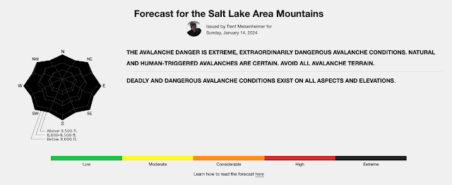
Source: Utah Avalanche Center, issued 14 December 2024

About 30 years ago, when I was leaving Seattle for Salt Lake City, famed avalanche forecaster Sue Ferguson, a former director of the Utah and Northwest Avalanche Centers, told me that in Utah you can avoid many avalanches by simply waiting three days after a storm before entering into avalanche terrain.  This was not meant to be rigorously followed advice as Sue knew as well as anyone that there is variance around the mean, but it was her way of saying that persistent weak layers are less common here and that patience is a virtue in Utah where we are often dealing with new snow and wind-driven instabilities that can heal quickly.  

However, there are years when that is clearly not the case and this is one of them.  That persistent weak layer may have strengthened some in some areas, but we are still dealing with a Russian Roulette snowpack.  We still have considerable avalanche danger on a good portion of the avalanche rose and, as summarized by Drew Hardesty in today's report "dangerous and tricky avalanche conditions exist."  


Drew comments further that cautious route finding and conservative decision making are essential.  Indeed, many people that I know are laying low right now, staying away from of steep terrain.  

So, Steenburgh winter is here, but the green light is not on in the backcountry.  That said, the coverage is good in the aspens and reports are that the resort skiing has been quite good (I was in Steamboat last week and the snow conditions there were also quite good).  It is always good to reach 100" of snow depth and 20" of water at the Snowbird SNOTEL in January.  In the case of the latter, the median snowpack doesn't reach 20" until February 1st.  

Saturday, January 20, 2024

#SkiColorado

I spent the last week in Steamboat attending a meeting known as the Weather Summit and helping out a bit at Storm Peak Lab, a major meteorological observing facility at the top of the ski resort that is now operated by the University of Utah after it was transferred over from the Desert Research Institute. 

We arrived late Tuesday, which turned out to be the only day we saw the sun.  

The meeting was structured to allow for morning turns, which featured dust on crust Wednesday morning and cream on crust Thursday morning.  On Wednesday morning, as the airmass warmed, there was a transition in snow crystals from lightly rimed dendrites to rimed crystals. Steamboat has trademarked the phrase Champagne Powder (don't tell the French about this) and the morning snow was of such quality (although not deep).  By mid morning though, the dendrites were heavily rimed, as illustrated by the snow crystals on my shell.

A lot of work has been done using data from Storm Peak Lab to examine cloud characteristics and snow growth processes.  A favorite paper of mine is Hindman et al. (1994) which examined the concentration and size of cloud droplets over a multiyear period at the lab.  Out of 274 samples, 241 (88%) exhibited what we would expect in clouds with "continental" characteristics where as 33 (12%) featured clouds with "maritime" characteristics.  

Source: Hindman et al. (1994)

Over the continents, there tends to be a lot more very small particles in the air that are referred to by scientists as aerosols. Some of these aerosols can serve as cloud condensation nuclei, or CCN.  These become the "birthplace" of cloud droplets.  Because there are a lot more CCN, continental clouds tend to feature more cloud droplets per volume of air.  These droplets also tend to be smaller.  In contrast, in maritime clouds, there are fewer CCN, there tend to be fewer cloud droplets, and they tend to be larger.  All else being equal, those larger droplets more efficiently rime falling snowflakes, leading to heavily rimed snow crystals (such as those pictured above) or graupel.  

There are other pathways to creating rimed crystals or graupel in clouds even in continental clouds, but clouds with maritime characteristics do it more efficiently.  I didn't take a look at the aerosol concentrations on Wednesday, but on Friday they were low, so perhaps this was a contributing factor to the development of rimed crystals on Wednesday.