The primary tool for forecasting smoke in the United States is a modeling system known as HRRR-Smoke.
HRRR stands for the High Resolution Rapid Refresh, a high resolution developed by the NOAA Earth System Research Laboratories in Boulder Colorado. The HRRR is actually based on the Weather Research and Forecasting model (WRF), which was developed by the National Center for Atmospheric Research. Yes, I know this gets confusing. I can't keep up with it either.
HRRR-Smoke is based a version of the WRF model that includes coupled air chemistry, known as WRF-Chem, in order to simulate smoke emissions and transport. It also allows for the effects of smoke particles and other aerosols to be considered for the models precipitation processes. This is known as "aerosol aware microphysics parameterization."
HRRR-Smoke forecasts can be accessed at many web sites and on many apps including OpenSnow. They can also bee accessed through NOAA at https://rapidrefresh.noaa.gov/hrrr/HRRRsmoke/. Smoke transport is inherently three dimensional. There are times that smoke concentrations may be high aloft but near zero at the surface and others where concentrations are hazardous at the surface. This site provides graphics of smoke concentrations (in µg/m3) near the surface, 1000 ft above ground level (AGL), and 6000 feet AGL. Here, the surface or ground is based on the model topography, not the real topography. Although a reasonable approximation, the HRRR does not resolve fine-scale topography, such as the details of the ridge-canyon geometry in the central Wasatch Range. There is also a vertically integrated smoke product, which sums the concentrations vertically.
Below is the near-surface smoke analysis from HRRR-smoke for 1200 UTC 31 July (6 AM MDT this morning if you are reading this on Wednesday). The highest concentrations are near the Park Fire in northern California. High concentrations extend westward from this fire across northern Nevada and into northern Utah. Values in the Salt Lake Valley are around 25-30 µg/m3, which is consistent with the Utah DAQ observations from Hawthorn Elementary School this morning, which are just over 30 (i.e,. the upper end of "moderate" air quality).
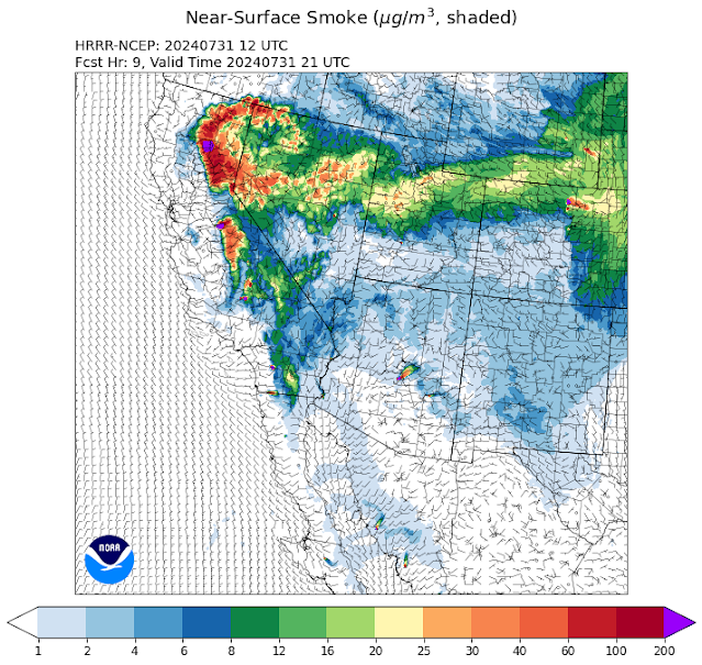
Below is the near-surface smoke forecast valid for 2100 UTC 31 July (3 PM MDT this afternoon). Noticed that concentrations have dropped over northern Utah, although a sliver of > 25 µg/m3 remains over the Salt Lake Valley. These decreases partly reflect a weak trough passage and the development of low-level northwesterly flow, which is bringing in air with lower smoke concentrations.
By 12 UTC 1 August (6 AM MDT Thursday), near-surface concentrations in the Salt Lake Valley are generally in the 12-20 µg/m3 range, although values are much lower just to the north. Maybe we can get lucky and some of that air will get in here.
These forecasts are quite useful, but not without their challenges. For example, there can be missed fire detections, due to limitations in satellite imagery or ignitions near or after the initialization time. Models are also used to estimate fire emissions and plume rise. The forecasts are also dependent on the HRRR forecast fidelity, which affects transport. There can also be a lot of interactions between the fire, smoke, and atmosphere that are difficult to forecasts. For instance, areas of dense smoke can effectively limit daytime solar heating, leading to thermally driven circulations that are very difficult to accurately forecast.
In the long run, I suspect that "smoke aware" weather modeling systems like HRRR-Smoke will be the norm. These modeling systems, whether based on traditional numerical approaches or machine learning, will include smoke, other aerosols, and atmospheric chemistry to enable the prediction of air quality and impacts on temperature, circulations, and precipitation.


No comments:
Post a Comment