At least 36 people have been killed by tragic wildfires on Maui. The NASA/USFS Fire Information Resource Management System shows fires/hotspots around Lahaina and over interior Maui.
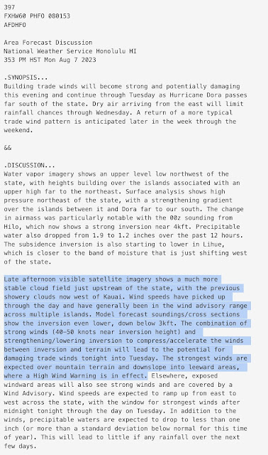
Prior to this event, the National Weather Service was well aware of the potential for strong and damaging trade winds, as evident in the forecast discussion below from 3:53 PM HST Monday August 7.
They had also issued a red-flag warning for leeward (west) areas on the islands due to low humidity and strong winds with gusts over 60mph. It was noted that any fires would "spread rapidly."
I could not find any observations from the Lahaina area through my usual channels. Instead, I will use data from the Kealia Pond National Wildlife Refuge with is about 20 km to the southeast (and south of the high terrain immediately east of Lahaina. This difference could be very important as the topography of the Hawaiian Islands has highly localized impacts on airflows. That said, if we look at a 7-day time series from this location, we see dramatic and important changes occurring on the 7th and 8th.
Prior to the 7th, temperatures were generally reaching or just below 90°F each afternoon. Dewpoints were between 60 and 70°F. Winds would pick up each afternoon, with gusts peaking at about 30 mph.


Much of the West side of Maui has been under pretty bad drought with even water restrictions in place. This wildfire spread quite rapidly over the Western Mountains and Upcountry (Kula), then went downslope with the winds and incinerated Lahaina.
ReplyDeleteIt looks like the nonnative ornamental grasses over former agricultural areas + long-term drought + perfect atmospheric conditions with the hurricane passing to the south = this terrible disaster, perhaps one of the worst in Hawaii's history.
One other thing, 95 is very hot for Maui, as their record high is 97. It's becoming more commonplace for these very warm temperatures, which just further serves to dry out the vegetation.
Planned disaster adventure epic melodrama film to be set in Australia Hawaii & California USA with new actors and actresses to portrayed as victims and heroes of Lahaina tragedy filming underway by early spring of 2025 soon.
ReplyDelete