I never thought I'd say this, but we need this to stop. We need the onslaught of storms to end, for the snowpack to settle, and for spring to begin.
Snowdepths and snowfall amounts right now are just ridiculous. Let's start at the Ben Lomond Peak SNOTEL, which is at an elevation of only 7688 ft (I'm not sure why it says 8000 ft in the figure below). Snowpack water equivalent at that site is now 78.7 inches, the highest on record, easily toping the 74.0" observed in 1984 (yes, 1984 at this site was higher than 1983).
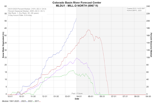
Down in the Cottonwoods, the Mill D North SNOTEL is now at 51.7", well above the prior 2011 record of 44.3". Records here, however, only go back to 1989 and don't cover those big early 1980s years.
Perhaps most relevant to what I want to talk about here is how steep the snowpack water equivalent has been rising at these and other sites. Mother Nature has added over 10" of water to the snowpack since March 15th. Snowbird has also added a bit over 10" of water since that time. Talk about load and stress!
Meanwhile, the Alta-Collins site picked up 19" of snow from 9 PM last night to 7 AM this morning, including a 6" increase from 1 to 1 AM. This is on top of the 14" that fell the previous night. Total snowfall for the season is now over
800 INCHES!
Insane. They are also well over 200 inches for the month. I'm not sure what the resort record is, but the Alta-Guard snowfall record for a month is 244.5" set in December 1983. We must be getting close to that.
All of this puts us deep into outlier territory. Readers of this blog know that I like to say beware when the atmosphere is in outlier mode. I woke up this morning, saw the huge snowfall numbers, and looked at the forecast and got a pit in my stomach. An incredibly deep snowpack. So much new snow. Slide paths that are greased.
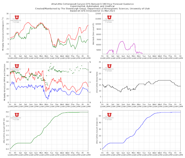
And then I looked at the forecast and saw the GFS, after a break tomorrow, was forecasting over 3" of water and 40" of snow for Sunday through Tuesday.
Then I about threw up. The NAEFS mean is lower and around 2" of SWE, but still a significant event.
This must stop now. Both canyons are currently closed. The UDOT Cottonwood Canyons site reported that a natural bank sluff hit the road this morning. They are extending the estimated time of opening (ETO) now to 11 AM. The last I looked, there is no ETO for Little Cottonwood. Snow safety crews have been working the ragged edge all season, but especially over the last month. Avalanche threats exist not only in the Cottonwoods, but also along other highways where such slides are less common and only occur in big years.
And we haven't even talked about the runoff.
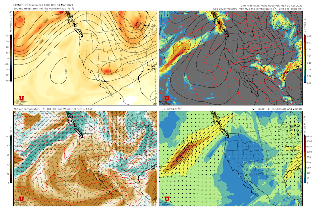
I am hoping we get through this cycle without incident and that after that we see a shift to something resembling spring with some longer breaks between storms. Both the GFS and the ECMWF are advertising a high-amplitude ridge to develop along the Pacific Coast by later next week and be parked there by 0000 UTC 10 April (6 PM MDT Sunday).


while your arguments are mature and very well thought out, I fear that deep down most of us are a bit less measured and in our hearts are saying f___ it, lets just see how far it will go, we can skin up in august and september to make up for the missing days. (Sort of like how we all feel about the indictment... very somber but giddy inside!)
ReplyDeleteWhat a weird comment… who brings up the indictment on a weather post? This is America (now).
DeleteAgreed. What a loser getting giddy about a politically motivated indictment
DeleteI had to laugh at this comment anyway, meh to the negative Nancys that commented after. Thank you for maturely explaining the contrast that gave rise to a legitimate boost of irony. Good job.
DeleteHaha I also loved this comment, well done 💪💪
DeleteWe’ll see how happy you are on election night 2024
DeleteLove this comment. And yep, giddy as well, even more giddy for the special prosecutor indictment coming and the one from GA.
DeleteIn jest - maybe the runoff will rip out the entire road, give us a fresh canvas for a train and avy sheds
ReplyDeleteDramatic! Why though should it take a real catastrophe for people to finally do the best long term thing for LCC. Doable. Affordable. Expandable. Beautiful and scenic. Permanent. Damn.
Delete… forgot the most important specific point: sufficient capacity!
Delete*Break in PI
ReplyDeleteHave you looked at the SWE for the Mono-Owens Lakes Basin? Talk about snowmageddon. https://www.nrcs.usda.gov/Internet/WCIS/AWS_PLOTS/basinCharts/POR/WTEQ/assocHUC6/180901_Mono-Owens_Lakes.html
ReplyDeleteIf you like the 53.7" of SWE at Mono-Owens you will love the 116.1" of SWE at Lower Lassen Peak https://www.nrcs.usda.gov/Internet/WCIS/AWS_PLOTS/siteCharts/POR/WTEQ/CA/Lower%20Lassen%20Peak.html
DeleteConsidering the Snowbird SNOTEL site SWE record is 75.1" in 2011 with data only going back to 1990 I think it is safe to assume the SWE would have been in the 80" range during some of those early 80's years.
ReplyDeleteThat may be true. Probably snow course data for LCC back then. I need to have a look at some point. WOuld correspond well with current as that would be collected around 1 April.
DeleteAs someone who struggles with s.a.d. I concur.
ReplyDeletehttps://www.alta.com/weather High Rustler webcam sums it up
ReplyDeleteEden 5,500 ft 2.25 ins SWE 18 ins plus. Three snow plows toppled in Ogden Valley. School bus also in ditch. There are human consequences to this.
ReplyDeleteBen Lomond SNOTEL eqt is buried.
I see your point, but road closures and lift closures (Snowbasin digging them out) still an issue. Snow only lasts so long in late March.
ReplyDeleteHopefully things open up for tomorrow.
Wuss
ReplyDeleteWhat is with so many of y’all still asking for more? I agree 100% with Jim. Another important consideration: if we keep putting cold storms with no melting up there later in the year, what happens when a monster high inevitably moves in and we get 80s/90s/100s in the valley with all that snow? We need to start slowly melting it or the flooding risk might be a lot worse than you might consider..
ReplyDelete👎
Deleteits nature. its going to do what it does, and get out of the way when it goes off. I want as much fuse added to the man made arsenic bomb as possible. personally i think folks around here need a fat dose of nature humbling them too
DeletePray for snow & f___ it, lets just see how far it will go
DeleteLet's get this snowpack into mid May without any melt. #beat83
ReplyDeleteWhat we need is a storm that will close the canyons permanently.
ReplyDeleteThis next one might just do it. Next winter storm watch calls for up to 4 feet in the cottonwoods
DeleteHeard two great “mot juste” comments at the Jupiter chair today (btw snow was fantastico!): 1. “Today is January 90th!!”
ReplyDelete2. From a MTB meme: “Pray for DIRT!!”
… mic drop
ReplyDeleteChanneling a bit of Monty Python, "Every flake is sacred. Every flake is great!"
ReplyDeleteLet them all in…!
Delete