Tuesday, February 28, 2023

Oh What a Night!

You can't stop Mother Nature this season.  More insane numbers from the Wasatch.  As reported by the Utah Avalanche Center this morning, storm totals for the PC Ridgline are now .95–1.05" water and 15–22" of snow and Upper Cottonwoods 1–2.5" of water and 16–35" of snow.  The Ogden and Provo area Mountains have also been blessed with big dumps. 

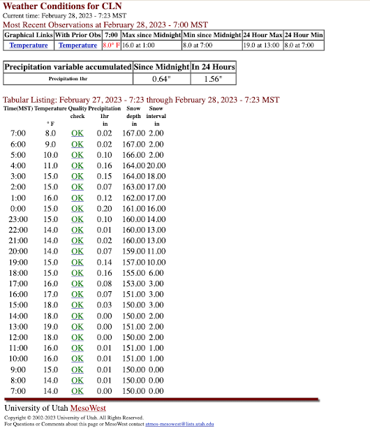
Snowfall late yesterday was intense at Alta-Collins. Hourly snow interval observations show an increase in snow depth from 3 to 10 inches in two hours from 5 to 7 PM.  Normally the board is wiped between 4 and 5 PM, but I can't tell if that was done as the interval remained at 3 inches.  Given the intense snowfall rates, it is possible it was wiped and it basically was snowing 3" an hour starting at about 4 PM.   

I've heard that the Cottonwoods were a mess during this period and that the overnight road closure was moved up to 8 PM.  If so, I suspect both were closely related to the heavy snowfall. 

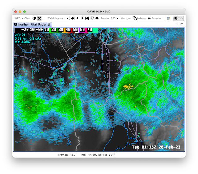
Radar observations during the period of heavy snowfall showed strong orographic enhancement of precipitation in the southern central Wasatch and Mt. Timpanogos area, with spillover to the Deer Valley Area.  There was also enhancement over the southern Stansbury and Oquirrh Ranges.  

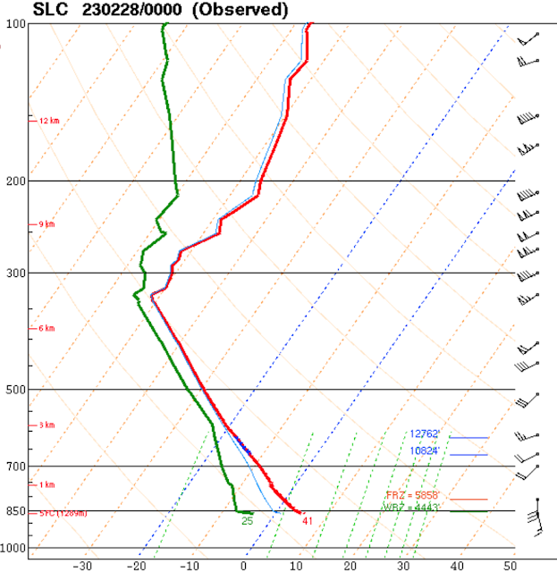
The flow during this period was southerly at valley level and southwesterly at crest level and, perhaps most importantly, the dendritic growth zone, a layer in which temperatures are between -12 and -18˚C and conducive for the formation of dendritic, low density snow, sat right at and above crest level (10824–12762 ft as identified by blue lines in the plot below).   


All of these things are easy to spot in hindsight, but what separates a garden variety snowfall from an intense one is hard to identify reliably in advance.  Just because the ingredients are there, doesn't mean Mother Nature will bake the cake. 

Embedded in this storm was something that I don't understand.  For an extended period of time, a southwest to northeast oriented band developed over the Lone Peak Massif (just north of the cursor in the loop below) and extended downstream over Little Cottonwood and upper Big Cottonwood Canyons.  At ties, you can see siilar bands forming downstream of Mt. Timpanogos and even the southern Oquirrh Mountains.  


I have seen such features at times before and have event posted on them previously (see Something I Don't Understand).  They have been identified in the Alps, but I am not sure if the ones we see here are a close cousin or a distant relative.  Regardless, I wish we had a very detailed snowfall measurement network to identify the impact of this band on snowfall distribution in the Wasatch.  

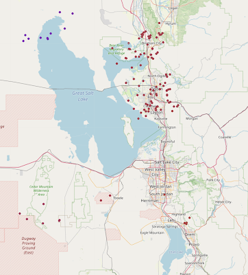
Something else is evident in the loop above and that is the cold front that came through last night with a bang.  First the wind woke me up and then I saw a couple of flashes of lightning (but I heard no thunder).  I've heard reports of thunder and lightning around the area, and lightningmaps.org observed many strikes along the northern Wasatch Front, two in Tooele, one in South Jordan, and four in Utah County.

Source: lightningmaps.org

Paraphrasing Frankie Valli:

Oh, what a night
Late February back in twenty three
What a very special time for me
As I remember what a night

Sunday, February 26, 2023

Unsettled

I've never liked to used the adjective unsettled to describe the weather.  It always seems like a bit of a cop out.  But for the next few days, it might be the best option.  

The large-scale pattern features the passage of three upper-level troughs across the western US over the next 4-5 days.  The first passes to our south today and is the remnant of the beast that has brought cold and snow to California the past couple of days.  

The second isn't as deep, but brings with it a strong cold front that moves across Utah late Monday.  

The third, evident just upstream of the northwest coast of the US in the plots above, is forecast to move across Utah late Thursday.


Active would be another adjective that one could use to describe this storm period!

The GFS-derived Little Cottonwood forecast shows what I'll simply call "periods of snow" from today through Tuesday Night with another pulse coming in Thursday night.


The net total water equivalent for the period is just over 2 inches of water equivalent and 30 inches of snow for Alta-Collins.

The downscaled SREF only goes through 0000 UTC 2 March (5 PM MST Wednesday), but most members are putting out over 2 inches of water and 35 inches of snow.  


Bottom line is that this looks like another active week that will add to the snowpack and keep the ski conditions "fresh".  The pattern is also a cold one, which will help preserve the powder and will give periods of snow to the valley as well.  

Thursday, February 23, 2023

More Good News for Powder Lovers

I have a friend who likes to talk about BDOY or his Best Day of the Year.  Some seasons, the candidates for BDOY are limited, but not this one.  

I had an amazing powder day yesterday in mid-elevation terrain outside of the fabled tricanyon area.  The coverage was better and the powder deeper than I've ever seen in that zone.  Hopefully blogger doesn't mangle the great video captured by my friend Colin.


Was it the BDOY?  I have no idea.  I've had so many good days of backcountry powder that they all just blur together.  

And I like what I am seeing in the medium range forecasts, which continue with the progressive pattern that brings storms to our area from the northwest.  There's not a lot of agreement on the timing and strength of individual systems, but overall, most the NAEFS members keep things fairly active through the start of March.  


And if I courageously peak beyond that, the pattern continues to look favorable, although I don't want to jinx anything.

This is a really great pattern anytime of year, but especially as we approach early March.  With the high sun angle, cold storms and cold weather in general are preferred.  

The pattern is also consistent with what we have seen for much of the winter.  Below is an analysis of the departure of 500-mb heights from average for the period covering November, December, and January showing a tendency for higher heights over the North Pacific/Alaska and lower heights over the western continental United States.  


Why has this pattern predominated?  I have no idea and I don't care.  Let's just roll with it and enjoy the powder.  

Tuesday, February 21, 2023

Here We Go

Super excited for the events to unfold later today through Wednesday.  The models continue to be on track with a major, all elevations snow event for Utah.  

The large-scale setup for this event is an amplifying upper-level trough that digs southward along the Pacific Coast.  As discussed in an earlier post, this amplifying system is actually connected to the development of two powerful cyclones over the northwest Pacific, which amplify the immediate downstream ridge over Alaska, which in turn amplifies the trough along the Pacific Coast through a process known as downstream development.  The GFS forecast valid at 0000 UTC 22 February (5 PM MST Tuesday) shows all of these features nicely with the northwest Pacific cyclones marked with Ls, the ridge with a zig-zagged line, and the trough with a dashed line.  

This is a highly dynamic situation with rapid amplification of the jet-stream pattern.  It is only through the power of numerical weather prediction that such a pattern change can be reliably anticipated days in advance.  We've been on alert for some time about this possibility, even if the details could not be confidently pinned down.  

As the upper-level trough digs down the Pacific Coast, the accompanying cold front slides into Utah.  The GFS forecast valid 0000 UTC 22 February (5 PM MST Tuesday, corresponding to the valid time of the hemispheric forecast analysis above), shows the cold front over central Nevada and northern Utah.  To the south of the front it is mainly dry.  To the north, heavy precipitation mainly in the form of snow.  


Note the sharp wind shift at 700-mb (10,000 ft above sea level) in the lower left hand panel above.  This is reflective of strong troughing that develops along the front downstream of the Sierra Nevada and extending across central Nevada and Utah.  

Eventually the cold front and associated trough become the locus for cyclogensis, falling pressures and the development of a low-pressure system over Utah.  By 1200 UTC 22 February (5 AM Wednesday), the low pressure system is centered over eastern Utah. 


In response to the developing cyclone, the front pivots over central Utah, surging southward through Nevada to the west, but stalling over the Uintas to the east.  The pivot point is somewhere near Provo, give or take 100 kilometers.  At 700-mb, a fully closed circulation develops that is roughly centered over Kamas at1200 UTC 22 February (5 AM Wednesday, lower left panel above).  This makes anticipating mountain effect on precipitation very difficult as much will depend on the track of that closed circulation and wind directions could change quite a bit during its passage.  Additionally, much will also depend on how far south the front pushes.  

I'll walk you through one model solution.  This is the high-resolution HRRR initialized at 1200 UTC (5 AM MST) this morning. The forecast valid 1800 UTC 21 February (11 AM MST Tuesday) shows the front just beginning to push into northwest Utah with some prefrontal precipitation over the central Wasatch, northern Wasatch, northern Wasatch Front, and Cache Valley.  Precipitation at this time would be valley rain and mountain snow, with perhaps some wet snow on high-elevation benches.  

By 0000 UTC 22 February (5 PM MST Tuesday), the front is on the doorstep of the Salt Lake Valley.  It is likely that precipitation has changed to snow at all elevations along the northern Wasatch Front and its probably just about to change to snow in the Salt Lake Valley.  Buckle up!


By 0300 UTC 22 February (8 PM Tuesday), the front has pushed through Tooele County and is entering Utah County at the surface, although the band is covering much of northern Utah County and southern Salt Lake County.  Expect heavy snowfall over the Salt Lake Valley this evening as the band moves through.  


Then the front stalls and begins to pivot.  The sequence of images below shows the frontal band lingering in the Wasatch Front region through 1500 UTC 22 February (8 AM MST Wednesday).


Periods of snow would likely occur in the Salt Lake Valley through that period, and then continuing into the day on Wednesday.  Accumulations will vary spatially and depend on local flow interactions with terrain.

The HRRR-derived snowfall forecast through 1500 UTC 22 February (8 AM Wednesday) is below.  I'll focus on accumulations through 8 AM tomorrow as that's a good time for both commuters and skiers, although periods of snow may continue through Wednesday.  The HRRR-derived snowfall forecast uses our University of Utah snow-to-liquid-ratio algorithm.  It calls for a big dump for the entire Wasatch Range with 18+ inches at all central Wasatch Resorts, 22 at Snowbasin, and 26 at Powder Mountain through 8 AM tomorrow.  The range in the Salt Lake Valley is from about six or seven inches to just over a foot at Cottonwood Heights.  If this forecast were to verify, the southeast bench would get the most snow in the valley.  

That's just one model run.  If we look at the downscaled SREF forecast for Alta-Collins, there is remarkably tight clustering.  By 22/15Z, corresponding to the period plotted above and through 8 AM MST Wednesday, the vast majority of members lie between 17 and 26 inches, although there are a few that are above that. 


The spread in the valley is greater, which reflects both precipitation amount and temperature uncertainties.  Through 22/15Z, the range is from about 2 inches to 9 inches for the University of Utah Mountain Meteorology lab.  


Bottom line is a significant event is on tap.  Below is the official Winter Storm Warning issued by the National Weather Service this morning for the Tooele and Rush Valleys, Northern Wasatch Front, Salt Lake Valley, and Utah Valley.

NWS Winter Storm Warning issued 6:26 AM Tuesday February 21.  Captured 9:10 AM 21 February 2023.

Note that accumulations in that warning cover the period from 5 PM this afternoon to 11 PM MST Wednesday and thus are somewhat higher than I discussed through 8 AM Wednesday. 

Monitor forecasts and buckle up.  
Sunday, February 19, 2023

Will Snow Miser Bring Us the Goods This Week?

If you've never seen the Rankin Bass Christmas Special A Year Without a Santa Claus do so soon as the epic battle between the Snow Miser and Heat Miser is not to be missed.  

I thought of the Snow Miser today as I glanced over the model runs and thought he could bring the goods this week.  Cue music.

I know it's not Christmas time but so what.  We are looking at the potential for a major, all elevations snowstorm late Tuesday and Tuesday night, with potential for things to linger into Wednesday, especially in the mountains.

Things look to really get going late Tuesday.  Below is the GFS forecast for 0000 UTC 22 Feb (5 PM MST Tuesday) with a cold front and associated precipitation draped across northern Utah.  


The beauty of this cold front is that as the upper-level trough digs along the Pacific coast, an intermountain cyclone forms along it, which slows its progress and causes it to pivot over northern Utah.  Below is the GFS forecast for 0600 UTC 22 February (11 PM MST Tuesday), showing the slow progress.  


The basic scenario is similar in the Euro, but the cyclone is a bit weaker and the frontal precipitation a bit farther south.  Under such a scenario, the Salt Lake Valley might miss out on the biggest accumulations.  They would go south to Provo, although the Salt Lake Valley would still get some.  


In an ideal world, the frontal precipitation band would stall over the Salt Lake Valley and we would get prolonged snowfall Tuesday night.  Then we continue to get some snow on Wednesday.  

Much will depend on the gory details, but the National Weather Service has issued a Winter Storm Watch from Tuesday Afternoon through Late Wednesday Night for the Northern Wasatch Front, Salt Lake Valley, Utah Valley, and other lowland regions.  

Source: NWS, captured 4 PM MST 19 February 2023

A watch means that there is the risk of hazardous winter weather, but its occurrence, location, or timing is still uncertain.  

This also looks like a powder producer for the mountains.  I lack the time this afternoon to take a close look and it is a complex system, but the GFS is generating about 2.5" of water and 35" of snow for Alta from Tuesday afternoon through Wednesday evening.  That would be a major 24-hour event if it were to verify.  All but two members of the downscaled SREF are producing at least 18" of snow, although for some members this includes a  few inches during the day tomorrow when we get a brush by.  


That said, these are major numbers being output by the downscaled SREF.  Sometimes the downscaling is a bit overdone during frontal periods, but I would expect a major dump starting on Tuesday afternoon.  We'll take a closer look at details as the storm approaches.  

My "wishcast" is that Snow Miser brings us the goods and we get a huge dump at all elevations.  The sun is getting higher and the sky and it is good to be greedy as we head into late February.  

Friday, February 17, 2023

Incoming?

Presidents weekend and week are on our doorstep.  Brace yourselves!  Fox13 is reporting that the Salt Lake City International Airport is expecting Monday, the day after the All Star Game, to be the busiest day of the year.  It will be a busy weekend downtown.  I wonder if that will increase or decrease the usual holiday pulse to the mountains?  Time will tell. 

On the weather side, storms are incoming, but with some forecasting issues that give me indigestion early next week.  Saturday looks dry, but a passing cold front and upper-level trough will bring a quick hitter storm Saturday night and early Sunday.  

Then we transition into a moist northwesterly flow for Monday and Tuesday.  The GFS integrated vapor transport valid 0000 UTC 21 February (5 PM MST Monday) shows large vapor transport indicative of an atmospheric river wrapping clockwise from Hawaii around a high pressure system centered near 40˚N and then into the Pacific Northwest.  Although the flow is from the northwest in our region, in a strange sort of way, this is actually a pineapple express with moisture originating from near Hawaii.

Source: CW3E

Mountain snowfall on Monday will depend strongly on the where we are relative to the inland penetrating atmospheric river and associated upper-level jet stream.  The GFS provides one solution in which Monday we get some periods of mountain snow showers (top image below, valid 5 PM MST Monday), but things really pick up on Tuesday (bottom image below, valid 5 PM MST Tuesday) as a deep, developing trough in the northwesterly flow moves onshore, a cold front pushes across the Intermountain West, and the jet sags southward.


The storm would continue with the cold frontal passage Tuesday night and then periods of post-frontal snow showers on Wednesday.  

The ECMWF high-res is drier, which is not unusual, with less precipitation on Monday, but it also brings the goods Tuesday afternoon (forecast below valid 5 PM MST Tuesday) and Tuesday night.  


It's always good to consult ensembles, but if you want spread, last night's 52-member downscaled NAEFS plume for Alta is ridiculous and caused me to get a good laugh.  There's the weak system on Sunday and then some models give us something on Monday, others not, and then for the big storm on Tuesday and Wednesday (or into Thursday) the spread is enormous.  In general, the GEFS is wetter than the Canadian (CMCE) members, but the driest member of the NAEFS produces less than a half inch of water and 10 inches of snow for the entire 168 hour forecast and the wettest over 6 inches of water and 110 inches of snow!  


If we were to throw in the ECMWF ensemble, which I can't show here, undownscaled it comes in with a mean for Alta at just over 1.5 inches of water through 6Z 23 Feb (11 PM MST Wednesday), which covers most of the storm period.  This is near the downscaled Canadian mean.  

The cause of all the ensemble spread is the deep, developing trough in the northwesterly flow.  It essentially develops out of nothing, in response to two intense cyclones that form over the northwest Pacific Ocean, through a process known as downstream development.  The loop below shows the evolution of sea-level pressure (color contours) and 500-mb heights from 1200 UTC 19 February (5 AM MST Sunday) through 1200 UTC 22 February (5 AM MST Wednesday) and illustrates the development of the intense cyclones at left over the northwest Pacific and the subsequent development of the trough over western North America.  


There tends to be a great deal of sensitivity of the forecast in the downstream development region, which is why there is such a huge range in the NAEFS ensemble.  The amplitude and track of the upper-level trough will ultimately affect precipitation in our region.  Hence my indigestion.  

I suspect we will see more clustering of the model solutions emerging in the next couple of days.  Right now, I think things look good for a significant storm early next week, possibly a big one, but best to say that details remain uncertain until we see more agreement.  

Wednesday, February 15, 2023

Post Valentines Day Winter Update

February 14th is now behind us, leaving only 2 week to go in meteorological winter (consisting of December, January, and February) and also until the end of inversion season.  Although inversions can linger into early March, they are typically not the monsters that can exist through February.  

My impression is that this winter has been a little cold, but that's not supported by the observations from the Salt Lake City International Airport.  The mean temperature at the airport from December 1 to February 14 was 32.9˚F, which is comparable to the last two winters and the 39th warmest out of 149 winters since 1876, putting it ahead of 73% of the previous winters.  

Source: https://xmacis.rcc-acis.org/

The National Weather Service Salt Lake City Forecast Office has a nice graph that summarizes meteorological conditions at the airport for the water year, which begins on 1 October.  As shown below, the period from late December through mid January was generally warmer than average.  We've had a couple of excursions of cold, but nothing extreme (nor have we had extreme warmth).  

Source: https://www.weather.gov/slc/CliPlot

Basically, in terms of temperature at the airport, there isn't anything all that exceptional about this winter.  

What about the mountains?  Observations are not as complete at mountain sites, so I'll use the National Centers for Environmental Information divisional time series for the northern Mountains, which considers all available observations.  This covers December and January.  For those two months, the average temperature was 21.4˚F, just a shade above the 20th century mean of 20.9˚F (plotted) and a bit below the 1991-2020 average of 22.5˚F (not shown).  So, pretty close to average.  

Source: NCEI

Perhaps my impressions are also affected by snowfall.  Curiously at the airport, snowfall for the water year is currently almost right at average, with 38.7" so far.  I suspect that average is for 1991-2020, so perhaps we are actually a little below the 20th century average (I should calculate this, but I'm feeling lazy).  This despite precipitation being above average, so at least at the airport, the fraction of precipitation that has fallen as rain and/or the density of snow have been running higher than average.  

However, it has been a very good year at upper elevations, as everyone knows.  Basin-wide snowpacks are above median for February 14 statewide and in many cases well above median.  


That gives us a decent lead heading into the 4th quarter, but Mother Nature still has time to snatch defeat from the jaws of victory if she decides to give us a dry, warm March.  If you are rooting for the Great Salt Lake, you might notice that it is the Bear and Weber basins that have the smallest buffer relative to median, and they represent a majority of the Great Salt Lake inflow.  A look at how individual SNOTEL stations rate relative to the median water year peak shows many sites in the upper and lower Bear drainage ate still at 70-89% of peak.  


Thus, the natural snowpack "reservoir" is still not full at some sites.  Mother Nature still has time to snatch defeat from the jaws of victory if she shuts down the storm track and gives us a mild March and April.  For a big runoff, we really want the active pattern to continue until at least early April.  Let's hope that happens.  Good for skiing.  Good for runoff.  Good for the Great Salt Lake (assuming that water gets to the lake). 

Sunday, February 12, 2023

Terra Incognita Tours

Tours on the west side of Lone Peak were referred to by Dave Hanscom and Alexis Kelner in their classic Wasatch Tours book as "Terra Incognita Tours."  

It may be hard to believe today, but much of the southeast Salt Lake Valley was undeveloped back in the day.  Trophy homes didn't dot the east bench.  Even when I moved here in 1995, there wasn't much in the Draper area and Suncrest did not exist.

Even today, the canyons that drop westward down from the Lone Peak massif are largely unexplored and inaccessible, although there are a few with trails, albeit trails that are quite steep and often difficult for ski access.

In the last big season, 2010/11, I toured a couple of times in Big Willow Canyon, which is the first major canyon to the north of Lone Peak.  It can be accessed by a narrow hiking trail, known as the Sawmill Trail, from Hidden Valley Park in south Sandy.  

I finally returned yesterday. It was a much harder tour than I remembered!  The Sawmill Trail climbs steeply, with limited snow cover, as you ascend through the lower elevations.  

I was able to skin up the entire thing, but my partners occasionally booted.  On the exit, we walked the the last 1000 vertical feet down.  

Mid elevations were choked more with trees than I remembered.  Eventually, one breaks out (thankfully!) into open terrain, although it takes about 2500 vertical feet of climbing to get there.

At this point, the spirits are lifted as you climb farther and farther above the Salt Lake Valley.  


There are many options in the upper canyon, nearly all with serious avalanche potential and in some cases serious exposure.  This is not a tour for anything but the safest days.  Below is a photo looking south toward Lone Peak, the Big Willow Aprons, and Upper Bells Canyon.  


And westward to Wasangeles.


I wish I could say we found deep, untracked powder, but we didn't.  Big Willow faces west and thus aspects with a slight south exposure were crusted and those with a slight north exposure were mainly wind jacked.  Still, this is a remarkable place to ski.  


However, a tax must be paid for admission and exit.  


I debated whether or not to do this post about Big Willow, but most sane people will not do such ski tours.  The ratio of effort to skiing is high and this part of the Wasatch gets less snow and more wind than the Cottonwoods, so there are also good reasons to stay away.