
Astronomical spring began yesterday, so it is worth taking a moment to examine the snowpack situation across the west.
As you may recall, we entered March with the western snowpack generally at or below median in most drainage basins.
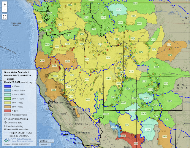
 |
| Source: NRCS |
For the most part, things haven't changed much over the past 3 weeks. Some basins have climbed a bit closer to median (e.g., southern and eastern Utah, Colorado), whereas others have lost a bit (e.g., Washington, Sierra Nevada).
 |
| Source: NRCS |
Northern Utah basins now sit at 80-85% of median, compared to 71–80% on 1 March. That's good, but still concerning. For the Jordan, which includes the central Wasatch, we now sit at 13.8" of average water equivalent at SNOTEL stations compared to a median of 16.9".
 |
| Source: NRCS |
However, the situation is arguably worse than that for two reasons. First, the green line above is the median daily water equivalent. Because of differences in the timing of peak snowpack from year to year, it underestimates the median maximum water equivalent, which is the green x on the graph above and sits at 20". The median date of that maiximum is April 8, so we have a lot of ground to make up with 2 weeks to go.
This week will not help. The dice are stacked for little to no precipitation through the 27th.


So basically, this will be a warm, dry week with substantial losses of snowpack at low elevations and on sunny aspects.
I'm hoping the trails dry out for valley mountain biking.
No comments:
Post a Comment