
February is almost in the rearview mirror and it looks like we will enter March with snowpack across most of the western U.S. at or below median levels.
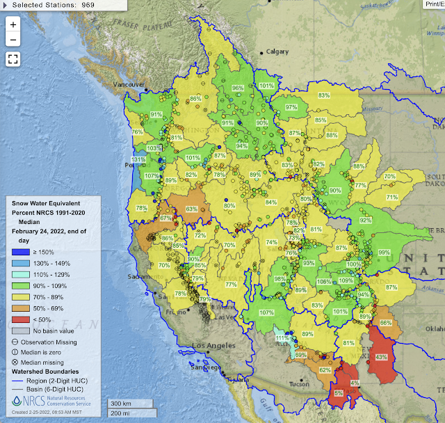
Below is the latest as of end-of-day February 24. The "fattest" snowpack relative to climatology is in the Northern Oregon Coastal Mountains at 131%, although this is an area that actually does not rely much on spring snowpack melt for runoff, so that number isn't all that relevant. There are 8 additional basins between 100 and 109% of median. The rest are below and many are below 90% of median.
 |
| Source: NRCS |
In northern Utah, the Jordan, Weber, Lower Bear, and Upper Bear sit at 76%, 73%, 78%, and 82% of median. The Jordan covers most of the creeks that emanate from the Wasatch Range east of Salt Lake City. Average snowpack water equivalent at SNOTEL sites in the Jordan sits today at 11.2" of water, compared to a median for the date of 14.9".
 |
| Source: NRCS |
That's a deficit of 3.7". Median snowpack in March increases 3.1", so basically we need to more than double the median increase in water equivalent in March to get back to median by April 1st. That's not impossible if we get into a good storm cycle, but a low probability outcome.
It's actually a bit worse than that because when you take the median of the snowpack water equivalent each day, you get numbers that are actually below what you get if you take the median peak water equivalent of the winters due to variations in the timing of peak snowpack. Median peak snowpack in the Jordan is 20", so we have to get 8.8" of water to get there, or almost three times the median increase in March snowpack water equivalent.
The bottom line is that we really need a monster March this year.
No comments:
Post a Comment