Following up on the previous post (Decimated Low-Elevation Snowpack), our woefully warm, windy, and dusty weather continued through yesterday when once again we hit a high of 70˚F at the Salt Lake City Airport. So, maximum temperatures for the last four days were 62, 70, 60, and 70 and the average temperature for the 4 day period was four day period was 51.9˚F, the 2nd highest on record behind only...wait for it...2020.
 |
| Source: NOAA Regional Climate Centers |
An unfortunate aspect of our snowpack observations is that there really aren't any in sites in lower elevation or south aspect areas that experience the most snow loss in these situations. Thus, we are stuck with sites in locations that tend to preserve snow, but even then, lower elevation sites suggest a ripening (warming to 0˚C through depth) and net loss of snow (note that sublimation could have contributed to these losses in addition to melting). For example, the Little Bear site at 6,458 feet just north of Powder Mountain ski area clearly show a peak in snowpack water equivalent in late February, and then a decline of 7.7 to 6.7 inches over the past couple of days.
Similarly, at Parley's Canyon, we see a decline in snowpack from March 7 to 8 when snowpack water equivalent dropped from 12.7 to 12.1 inches.
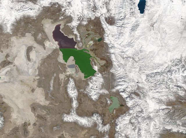
Losses were, however, much greater in areas that SNOTEL doesn't sample. Below is the MODIS satellite image from March 1 showing extensive snow coverage in the mountain valleys east of the Wasatch Range and snow coverage down to bench levels in the Salt Lake and Tooele Valleys.
Yesterday's image was somewhat obscured by clouds, but you can see the loss of snow in many of those mountain valleys and on the benches (as a side bar, check out some of the mountain wave clouds and the shadows they cast).
Cooling overnight has stopped the bleeding, but recovery will be slow. There's no direct hit storm this week and the strongest system is passing to our south and east. The downscaled SREF ensemble through 0000 UTC 13 March (5 PM MST Friday) in the Uinta Mountains and the mountains of central and southern Utah.
The Wasatch may get some, but it will come in fits and starts. For Alta Collins, the downscaled SREF mean through 0000 UTC 13 March (5 PM MST Friday) shows a mean of about 12 or 13 inches with no major (i.e., 10") storm periods produced by most of the ensemble members.
There are a few members that produce heavier amounts tonight or tomorrow morning or on Thursday or Thursday night. Hope that one of those storm pieces comes through, or it could be a slow recovery this week.


Could someone please describe how to access the MODIS snow cover images?
ReplyDeletehttps://worldview.earthdata.nasa.gov/. You can select Aqua/Modis or Terra/modis or other products in the upper left menu. These are two different satellites with different overpass times, providing 2 overpasses per day collectively.
DeleteThat will be great for spring skiing trip planning. Thank you!!!
Delete