Tuesday, March 30, 2021

Dirty Corn

Yesterday's cold-frontal passage probably brought more dust to the central Wasatch than snow.  Frontal passage at the University of Utah featured the usual wind shift and temperature drop, but also a spike in PM2.5 associated with blowing dust.


Peak concentrations at the U reached almost 15 ug/m3, which equates to a moderate air quality level.  

Cameras at the University of Utah caught the post-frontal dust and gravity-current-like nose of the cold front passing through the Salt Lake Valley.

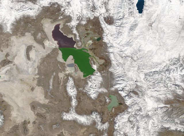
And check out the terrain induced flows over western Nevada with dust from the Carson Sink providing a great tracer.  So this event provides a new definition of "dust on crust" and puts a nail in the coffin of winter.  We might get into a good spring storm cycle eventually, but temperatures look to be rising this week and spring fever will be infecting far more people than the coronavirus.  The best options for skiing will be working the aspects for "dirty corn."  

Saturday, March 27, 2021

The Transition to Spring

I hope you enjoyed the cooler and somewhat snowier weather over the past week as it appears that things will be changing moving forward.  

Over the past week, I finally got out and got some ski touring in and enjoyed skiing powder again.  Yesterday provided a weather potpourri of low visibility and occasional snow and graupel showers with the cloud over acting to preserve the powder through the day (thankfully).  

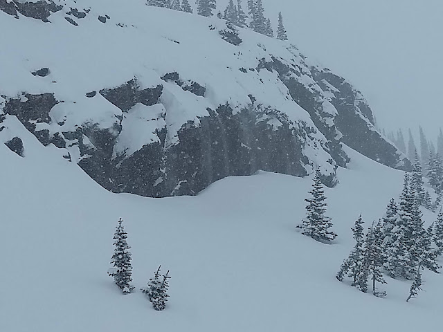
The graupel was generally light, but during one heavier period, we were treated to graupelfalls over some of the cliffs where we were touring.  

The snow over the past week on upper-elevation north-facing aspects survived quite well thanks to a progression of cold troughs.  Forecasts for the next week are not as optimistic.  The GFS and other models forecast a strong frontal passage Monday, but without a lot of moisture.  

Thus, it will be cold, but likely a dust on crust event.  The remainder of the work week looks dry, with temperatures moderating during the week.  

The NAEFS plume shows the vast majority of members generating 4 inches or less of snow for Alta with the Monday frontal passage.  There are, however, 3 that go for 10 inches or more, so I guess there's always hope. 

I'm sure we will see mountain snow at some point in April, but this coming week will probably mark a transition point in the 20/21 ski season.  

Wednesday, March 24, 2021

Some Oddities of the Utah/Wyoming Snowpack Numbers

It has not been a great snow season across Utah and southern Wyoming.  The vast majority of SNOTEL stations sit below median snowpack snow water equivalent. 

Source: NRCS

However, if you look carefully, there are some sites that are above average and in a few cases well above average.  In particular, check out sites along the north slope of the Uintas, over the Tavaputs Plateau in eastern Utah, and along the Laramie Mountains of eastern Wyoming.  

These are sites that are relatively dry, with low median peak snow water equivalents of 15 inches or less, but got creamed during the period of the Front Range Blizzard in mid March.  One outlier event has made their whole season.  

For example, Hickerson Park on the north slope of the Uinta Mountains has a low median peak snow water equivalent (< 10 inches), picked up over 4 inches of water equivalent during the Front Range Blizzard period, lifting them to median peak SWE (note that the green box is the median peak SWE, whereas the green line is the median SWE on each day and differ since peak SWE doesn't always occur on the same day each season).  

Source: NRCS

The East Willow Creek site on the Tavaputs Plateau of eastern Utah also did well during that period, despite being on a differing aspect.  However, the accumulation period at this site is more drawn out and I suspect it simply did well when the trough that spawned the Front Range Blizzard was sliding across Utah.  Others can perhaps comment with a better analysis.

Source: NRCS

Meanwhile, while I call it the "Front Range Blizzard" the reality is that the biggest accumulations in that storm were in the Laramie Mountains of Wyoming.  Check out the Windy Peak SNOTEL which picked up more than 5 inches of water equivalent.  
Source: NRCS

At dry locations like these, one huge event can make or break the season.  The Front Range Blizzard made the season at these sites, which would otherwise have limped into the end of March with below median snowpack.

Sunday, March 21, 2021

Nice Overproducer

There's gonna be some great skiing out there today.  The Utah Avalanche Center reports 12-17" in Big Cottonwood and 16-20" in Little Cottonwood.  That makes this storm a nice little overproducer and puts it into Goldilocks territory.  Radar still shows some snowshowers this morning. 

I decided to skip this morning's powder panic in the canyons and instead reflect back on yesterday, which provided a great example of why I prefer a dusk patrol over a dawn patrol.

I woke up with the frontal passage and enjoyed a breakfast of Tirolean Kaiserschmarrn, a high-density pancake that one shouldn't eat unless large calories are needed for ski touring.  Seeing the snow was just beginning, I enjoyed a morning tea and watched the World Cup finals.  No globe for Shiffrin this year, but it's hard not to like Austrian Katherina Liensberger who soars through slalom gates with a big smile on her face and won the slalom globe and final race of the season.  

I then topped up with a light lunch before picking up my son a bit after noon.  No traffic and, during our tour, we saw only two people in an area that often sees many.  

I figured even after waiting for the snow to stack up we'd be doing a lot of bottom feeding, but the high-density snow was just what one could hope for and smoothed things out more than expected.  Low expectations are the key to a happy life.  

It turns out that Liensberger is onto something.  Smiling really does make you a better skier.


I mentioned the snow was high density, but that's relative to average for Utah.  At Alta, the average water content of freshly fallen snow is 8.4%. Observations from the fancy "DEID" instrument run by the University of Utah at Alta-Collins (9700 feet) showed about 11% water content through 5 PM MDT yesterday.   

Such snow is perfect for a spring storm when sun crusts abound and must be buried.  It made for surprisingly good skiing and I suspect it will ski even better today after more snow overnight.  

Friday, March 19, 2021

A Decent Spring Cold Front

We are entering the time of year when we see the strongest cold-frontal passage.  This is due in part to the fact that (1) we actually get cold frontal passages this time of year and (2) the high sun angle drives processes that increase and sharpen the temperature contrast across the front.  

The cold front that will move across northern Utah tonight and tomorrow looks to be a good one, but the timing as currently forecast is off for Salt Lake City to maximize the sharpness and intensity of the frontal temperature drop.  

Below is the NAM forecast for 1800 UTC (1200 MDT) tomorrow showing a shift from prefrontal southwesterly flow and post-frontal westerly flow across the front, which is draped over the Salt Lake Valley.  

Because of the frontal passage, the change in temperature from this afternoon to tomorrow afternoon will be dramatic.  The forecast high for the Salt Lake City International airport for today is near 70˚F, whereas tomorrow afternoon we'll see rain changing to snow on the benches and temperatures more than 20˚F colder than today.  It will be a big change, but the front won't be quite as sharp or intense as it would be if it came in a few hours later when the sun would have had its greatest impact.  Still, something to look forward to and we need the precipitation.  Badly.

If you are looking for late-season powder, model forecasts for the storm vary from dust on crust to low-end Goldilocks.  For Alta, the SREF mean is around 6" of snow, but there are five members that crack the coveted 10" mark through Sunday morning.

The NAM is around 3", whereas the GFS, which is typically wetter, comes in with around 10".  We can't apply our snow-to-liquid ratio algorithm to the Euro, but in terms of water equivalent, it's even wetter than the GFS (0.7" vs. 0.53").

Probably the key to getting this thing to > 10" is the post-frontal crapshoot.  The GFS time-height section below shows post-frontal moisture and instability and northwesterly flow at some times and levels.  This could produce, but it's not a lead-pipe cinch since the relative humidity is moderately high and the flow is not locked in.  

The NWS is going for an 8-14" storm total, and I'm inclined to lean toward those numbers.  Tomorrow is probably a day to ski late as conditions will improve during the day and Sunday is probably a day to ski early.  

Thursday, March 18, 2021

When Science Meets Art

Several months ago, Alex Nabaum contacted me for snowfall data from Alta for a project he was working on. I get such requests from time to time, but this one was different because Alex is a professional illustrator and was interested in integrating this data into the concept for a poster he was working on.

I'll let Alex tell the story behind his poster and encourage you to check it and some of his other offerings out at https://www.skiposters.art/

40 years of Alta Snowfall Season Totals, Hidden in This Poster
Alex Nabaum

Poster © 2020 by SkiPosters.art

I’m a professional illustrator, skier and lover of ski resort history.

Especially Alta’s.

My grandfather Sherman Nabaum was chairman of the Winter Sports Committee that raised money to get skiing started at Alta in the late 1930’s.

A few years ago I went searching for ski resort posters to hang in my house, but was disappointed with the posters available.  Albeit beautiful, they all looked so similar. 

The unique visual story of each ski resort was not being told. 

I realized if I was going to have an authentic poster that told the unique visual story of my favorite ski resorts in a fresh modern way, I'd have to make them myself. 

So what’s the unique story of Alta?

To me it’s “Light, Deep and 1938”

Visually I tried to emphasize the light air filled and right side up quality of Alta’s snow by extending the transition between the white snow and dark blue sky. Blurring the line of where snow begins and sky ends.

Second is Alta’s deep snow history, which I hid in the columns of white dots.

The large white dots hide the last 40 years of Alta's snow season totals. Starting with the 1980-'81 season on the far left column and ending with the 2019-'20 season on the far right. If you squint your eyes, the chart becomes a bit more obvious. 

Each large white snow dot represents 50 inches of snow. For example, the off-the-chart winter of 1981-'82 with a total of 748" is the second column from the left and nearly goes off my chart as well.

There is also a very thin faint line that runs through the dots halfway above the V baseline (seen the detail picture below) that represents the 500 inch average.


The smaller white dots above the large dots are just artistic and serve to fade the snow into the sky and actually hide the bar chart a bit, so that the owner of the poster can enjoy counting and figuring it out over the years.

The large V shape of the snow/skyline (and the data chart’s bent V shaped X-axis) dramatizes the depth the skier is sinking into the deep snow. It is also meant to symbolize the deep V shape of Little Cottonwood Canyon which funnels storms to this little blessed micro-climate.

Also hidden in the dots is Alf Engen the ski jumping champion who scouted out Alta in 1935 and taught skiing there for forty years. He is hidden in the 1982-'83 season column of snowflakes, third column from the left.

In another nod to to Alta's 1938 beginning, I formed the letters out of bamboo ski poles which were commonly used at the time. The letter's simple red lines are also intended to echo the historic single seat red lift chairs preserved on the Alta welcome sign.

To find the other famous skier hidden in this poster and see how I use actual Alta snowmelt in the hand making of this poster and others, you can visit:  www.skiposters.art

Tuesday, March 16, 2021

Proposals for Little Cottonwood Canyon

It's been a while since we took a look at the proposed transportation alternatives for Little Cottonwood Canyon.  We last visited this issue on June 9, 2020 (see Little Cottonwood Canyon Transportation Alternatives) when public comment was being sought on three proposed alternatives: enhanced bus with no additional roadway capacity, enhanced bus with roadway widening, and a gondola from the mouth of the canyon.  All three include bussing enhancements along Highland Drive and Wasatch Boulevard.

UDOT actually received, identified, and evaluated 19 proposed alternatives from the public comments including everything from direct gondola to Snowbird and Alta from the gravel pit (eliminated as it would traverse wilderness areas) to a tunnel loop system with autonomous vehicles (eliminated due to a lack of existence of a fully operational system currently).  A full run down is available in the addendum report issued in late November 2020

Below is a summary of the five current alternatives.  

Additionally, you can watch a summary on YouTube below.

I remain disappointed with all of the plans so far for three reasons.  

First, there are no plans for stops anywhere in the lower or middle canyon.  The only stops are at Snowbird and Alta.  This is true even for the enhanced bus alternatives.  For the gondola, it explicitly says no unloading or loading at the proposed Tanners Flat angle station.  The ski areas are important, but Little Cottonwood is a multiuse canyon.  We need to think beyond resort skiing and how we can transform access and recreation in the canyon in general.

Second, it appears this would only be a wintertime operation.  If so, this is extremely shortsighted.  The tricanyons (Mill Creek, Big Cottonwood, Little Cottonwood) are heavily used year round and parking in the summer is already untenable.  The White Pine parking lot on a summer weekend day is filled by about 7:30 am and shortly thereafter cars are parked up and down the canyon for a half mile.  What will it look like in 2050?  Imagine summer operations and a stop or unloading point either at the current trailhead or at Tanners Flat, the latter with a newly constructed trail up the Pink Pine ridge to the Red Pine trail, enabling access to White or Red Pine Canyons.  

Finally, there are some big numbers listed above.  Anywhere from $334 million to $1.05 billion dollars in capital costs.  How will this be paid for and how will these changes affect access to the canyon for lower income individuals and families?  

If we are going to do this, we should aim for a "cake-and-eat-it-too" solution that benefits many and improves all recreation opportunities in Little Cottonwood. 

Friday, March 12, 2021

The Front Range Storm

If you are looking for oddities in the snow climate of the western United States, the area near and immediately east of the Continental Divide is a good place to start.  

First, let's talk about the snowiest month of the year, as illustrated in the plot below from Brian Brettschneider.  Most of the western United States and Canada west of the Continental Divide sees their snowiest months in December, January, or February.  However, near and east of the Continental Divide, the snowiest months are late in the cool season and in many areas in February, March, or even April.  


Focusing on the Front Range region of Colorado, based on average snowfall, the snowiest month in Boulder is March (16.1").  The least snowy month from November to April is actually January (9.7"). 

One of the reasons for this is that the late winter and spring are the peak period for the development of lee cyclones over southeast Colorado.  Such storms can tap into Gulf Moisture which is transported northward and eastward toward the Front Range.  

The models have been forecasting such a cyclone to develop tonight and tomorrow, resulting in a prolonged period of precipitation in the Front Range area over the weekend.  Below is the GFS forecast for 1200 UTC 14 March (0600 MDT Sunday) showing the cyclone centered over southeast Colorado with heavy precipitation encircling the system to the east and north.  Precipitation is heaviest north of the low center where strong frontal forcing and upslope flow over the high plains impinges on the Front Range.  


In these situation, there is often a band of colder, terrain-channeled flow near but upstream of the windward slope of the Front Range. Below is an example from a paper by Larry Dunn showing easterly flow over the plains to the east but, northernly flow near the Front Range (Boulder indicated by BOU). 

Source: Dunn (1987)

The boundary between those two flows, often referred to as a blocking front since the terrain channeled flow is a result of topographic blocking, is often the locus for enhanced vertical motion, resulting in heavier precipitation near and downstream (in this case west) of the blocking front.  

Source: Steenburgh (2014)

For the last couple of days, the GFS and members of the Global Ensemble Forecast System (GEFS), which shares components with the GFS, have been spitting out some insane snowfall numbers for the Front Range of northern Colorado.  Below is the downscaled NAEFS forecast plume from 0000 UTC 10 March.  The NAEFS is comprised of members from the GEFS and the Canadian (CMCE) ensemble.  The mean for Boulder for this weekends storm was around 2" of water and 20" of snow, but most of the GEFS members were above this, resulting in a mean closer to 25" of snow, whereas most of the CMCE members were below this, resulting in a mean closer to 15" of snow.  


The GFS is not included above, but it has been on the high side of the ensemble, putting out some insanely big numbers.  In contrast, the European has been more along the lines of the Canadian.  

A glimpse into the thinking of meteorologists dealing with this spread in forecasts is provided by the snippet below, taken from the National Weather Service Boulder Forecast Office Area Forecast Discussion issued 819 PM 11 March:

Source: NWS Boulder

The latest downscaled SREF has most members leaning toward a modest storm for Boulder, with most members in the 5-12" range, but a couple much higher than that.  


This is a storm that illustrates both the challenges of weather prediction, but also the challenges of forecast communication given the range of possible outcomes from modest to historic.  

Tuesday, March 9, 2021

Decimated Low-Elevation Snowpack, Part II

Following up on the previous post (Decimated Low-Elevation Snowpack), our woefully warm, windy, and dusty weather continued through yesterday when once again we hit a high of 70˚F at the Salt Lake City Airport.  So, maximum temperatures for the last four days were 62, 70, 60, and 70 and the average temperature for the 4 day period was four day period was 51.9˚F, the 2nd highest on record behind only...wait for it...2020.  

Source: NOAA Regional Climate Centers

An unfortunate aspect of our snowpack observations is that there really aren't any in sites in lower elevation or south aspect areas that experience the most snow loss in these situations.  Thus, we are stuck with sites in locations that tend to preserve snow, but even then, lower elevation sites suggest a ripening (warming to 0˚C through depth) and net loss of snow (note that sublimation could have contributed to these losses in addition to melting).  For example, the Little Bear site at 6,458 feet just north of Powder Mountain ski area clearly show a peak in snowpack water equivalent in late February, and then a decline of 7.7 to 6.7 inches over the past couple of days.  

Similarly, at Parley's Canyon, we see a decline in snowpack from March 7 to 8 when snowpack water equivalent dropped from 12.7 to 12.1 inches.  

Losses were, however, much greater in areas that SNOTEL doesn't sample.  Below is the MODIS satellite image from March 1 showing extensive snow coverage in the mountain valleys east of the Wasatch Range and snow coverage down to bench levels in the Salt Lake and Tooele Valleys.  


Yesterday's image was somewhat obscured by clouds, but you can see the loss of snow in many of those mountain valleys and on the benches (as a side bar, check out some of the mountain wave clouds and the shadows they cast).  


Cooling overnight has stopped the bleeding, but recovery will be slow.  There's no direct hit storm this week and the strongest system is passing to our south and east.  The downscaled SREF ensemble through 0000 UTC 13 March (5 PM MST Friday) in the Uinta Mountains and the mountains of central and southern Utah.  


The Wasatch may get some, but it will come in fits and starts.  For Alta Collins, the downscaled SREF mean through 0000 UTC 13 March (5 PM MST Friday) shows a mean of about 12 or 13 inches with no major (i.e., 10") storm periods produced by most of the ensemble members.    


There are a few members that produce heavier amounts tonight or tomorrow morning or on Thursday or Thursday night.   Hope that one of those storm pieces comes through, or it could be a slow recovery this week.  

Sunday, March 7, 2021

Decimated Low-Elevation Snowpack

A few numbers to summarize our current warm wave.

Yesterday's maximum temperature of 70˚F was only the 4th time 70˚F has been observed in Salt Lake City on or before March 6.  Other years with a maximum temperature of 70˚F on or before March 6th are 1879 (70, March 6), 1921 (71, March 3), and 2020 (70, March 6).  

Going back for the past two days, the average maximum was 66.0˚F, 6th warmest on record.

For the past three days, the average maximum was 63.0˚F, the also good for 6th.

For the past four days, the average maximum was 63.0˚F, 3rd warmest on record.

And finally for the past five days, the average maximum was 61.6˚F, 5th warmest on record.  

Thus, this warmth is not unprecedented, but it is on the high end of what has been observed in early March.  

Additionally, it is occurring during a season in which the snowpack is below average, especially in the lower elevations.  As such, the low-elevation snowpack has been decimated anywhere that gets afternoon sun exposure.  Nothing is left in my backyard and there's little left on the south side of the Avenues foothills.  I skied Mountain Dell yesterday morning and there were places where water had pooled on the trail as the melt rate exceeded the rate of drainage and infiltration into the soil.  This morning's grooming report reflected this:

"Skiing at Mtn Dell is STRONGLY discouraged this morning, Sunday, March 7. Ice is present in many locations, including hills and corners, making it very unlikely that you can stay upright or stay on the track. Yesterday’s very warm and sunny temperatures freed up a lot a water and last night it locked up hard. This morning’s grooming crew is having a hard time standing up if they step off the machines."

I skate skied at North Fork Park this morning and was pleased to find conditions were much better up there.  As usual, it's hard to believe how much snow there is at their relatively modest elevations (5700 feet).  However, things were getting soft and slow by the time I left at 11:30.  

Adding insult to injury, some dust was stirred up by yesterday's winds and lingers today.

The good news is that cold air looks to return this week.  Monday looks to be a repeat of Saturday with warm, prefrontal temperatures and strong southerly flow, but a cold front arriving late in the day or Monday night.  Tuesday looks colder thankfully, as does the rest of the work week.  

The question is, will we get some snow to stop the bleeding and improve conditions?  It's likely we'll get some, but the models in general are calling for it to come in dribs and drabs, at least at upper elevations, as indicated by the downscaled NAEFS forecast below for Alta.  


I guess every bit helps and there's always the chance that we end up with something on the high end of these forecasts. 

Friday, March 5, 2021

Diurnal vs. Persistent Cold Pools

The phrase cold pool is used for several meteorological phenomenon, including topographically confined layers of cold air that are confined by a warmer layer aloft.  

There are two types of cold pools: diurnal and persistent.  Diurnal cold pools form during the evening or night and decay with surface heating the following day.  Persistent cold pools occur mainly in the winter and last through at least one daily heating cycle or more.  Colloquially, persistent cold pools in northern Utah are known as inversions.  

There is a remarkable transition in the characteristics of cold pools in northern Utah from February to March.  During this period, days are getting longer and the angle of the sun relative to the horizon at a given time of day is increasing, resulting in a dramatic increase in the amount of solar energy intercepted by the Earth's surface and available to heat the lower atmosphere.

Through about the end of February, especially when there is snow on the ground, there's insufficient solar energy to destroy cold pools that reside in many northern Utah valleys and basins.  As a result, cold pools tend to be persistent.  They can hang around for days and, where there are local emissions, lead to worsening air quality.

But in early March, we cross a threshold and cold pools typically become diurnal.  They form at night, and decay during the day.  

In the Salt Lake area, some of the most impressive diurnal cold pools from in the Rush Valley south of Tooele and the Snyderville Basin near Park City.  Last night provided a nice example of the latter.  Below are observations from the Park City area at about 7:15 AM this morning, which is near the time of minimum temperatures.  At mountain locations, especially near ridgelines, temperatures were predominantly in the 20s.  For example, at the Mount Baldy observing site at 9347 ft elevation at Deer Valley ski area, it was 27˚F.

Source: https://www.wrh.noaa.gov/map/?obs=true&wfo=slc

However, at lower elevation in the Snyderville Basin, such as along I-80, US-189/40, and SR-224, in and around the area labeled "Parley's Park" on the map above, temperatures ranged from 12-15˚F.  Such a cold pool forms frequently on clear nights over the Snyderville basin in part because it is relatively enclosed, which favors light winds that limit mixing with the warmer air aloft.  

This time of year, however, the cold pool will erode quickly during the morning. Below is a time series of temperature, dewpoint, and relative humidity at Silver Creek Junction and the I-80 to US-189/40 interchange.  Focus in particular on the period from 1-4 March, which also featured clear skis.  There is a warming trend during this period with maximum and minimum temperatures increasing, but also a very large diurnal variation in temperature of about 45˚F between.  Temperatures tend to rise rapidly in the morning and then stabilize near the maximum for a few hours in the afternoon and then fall quickly near and following sunrise, before falling more gradually in the late night and early morning hours.  

Source: https://www.wrh.noaa.gov/map/?obs=true&wfo=slc

On the 4th, the diurnal variation was much smaller.  This was due to the clouds that moved in from Wednesday night to Thursday morning, resulting in less cooling.  Diurnal cold pools can be very sensitive to the presence of clouds.

Knowledge of these variations can be useful for skiers.  If skiing at the resorts, it's nice to know that it's warmer on the upper mountain and survival in the cold for a few minutes near the base will be rewarded on the upper mountain.  I like to skate ski at Round Valley, which is in the Snyderville Basin, and on days like this I try to time my arrival for right around the period when temperatures are reaching 30˚F and the snow is just warming up.  Typically this makes for comfortable temperatures and good snow before it gets too soft.

Wednesday, March 3, 2021

Storm for the South

The past few days I've been watching the models closely to see if the southern-branch storm that will bring some snow to the upper elevations of central and southern Utah tonight and tomorrow might give some love to the central Wasatch.  

Every now and then the models give a glimmer of hope, but the latest GFS keeps the precip to the south.  Most impressive with this storm is the very sharp transition in relative humidity and precipitation southeast of the central Wasatch.  

This is consistent with the vast majority of downscaled SREF members, 21 of which give little to no precipitation for Alta-Collins. 


If you must cling to hope, there are 4 that give around 4-5 inches and one that gives just over 8.  There's also the Euro, which does bring precip into Salt Lake County tomorrow morning.  

Source: pivotalweather.com

So, this really is a forecast of location, location, location.  If the storm stays to the south, it's probably a complete shutout.  If it shunts a bit northward, there could be some light accumulations late tonight or tomorrow morning.