Wednesday, April 27, 2022

The Great Salt Finger Lake

Given the meager snowpack that generally exists in northern Utah, it's no surprise that the Great Salt Lake is expected to drop to historically low levels this summer.  

Last year the lake dropped to its lowest measured elevation at Saltair, 4190.4 feet.  A look at the observations collected at Saltair by the UGSS since last year shows that the lake reached its maximum elevation in early May and dropped about 2.5 feet through fall.  

Source: https://waterdata.usgs.gov/ut/nwis/uv/?site_no=10010000&PARAmeter_cd=62614

The recovery during the winter and spring has thus far been pathetic.  We currently sit at about 4191 feet, nearly 2 feet below where we were last year.  The runoff situation isn't great again this spring.  About the only silver lining is that recent storms have helped the snowpack in the Bear River Basin, which is now running ahead of last year by a bit.  


However, that's not going to help a lot and I suspect we'll make a run at 4189 feet by early fall.  

I've been preparing some material on the future of the Great Salt Lake for the 2nd edition of my book Secrets of the Greatest Snow on Earth.  I'll be including a bathymetric map of the lake based on work by Dave Tarboton at Utah State to illustrate what will happen as the lake shrinks.  The deepest portion of the lake lies along a northwest to southeast axis.  As the lake shrinks, it will become increasingly confined to a narrow channel along this axis.  Basically, the Great Salt Lake becomes the Great Salt Finger Lake.  
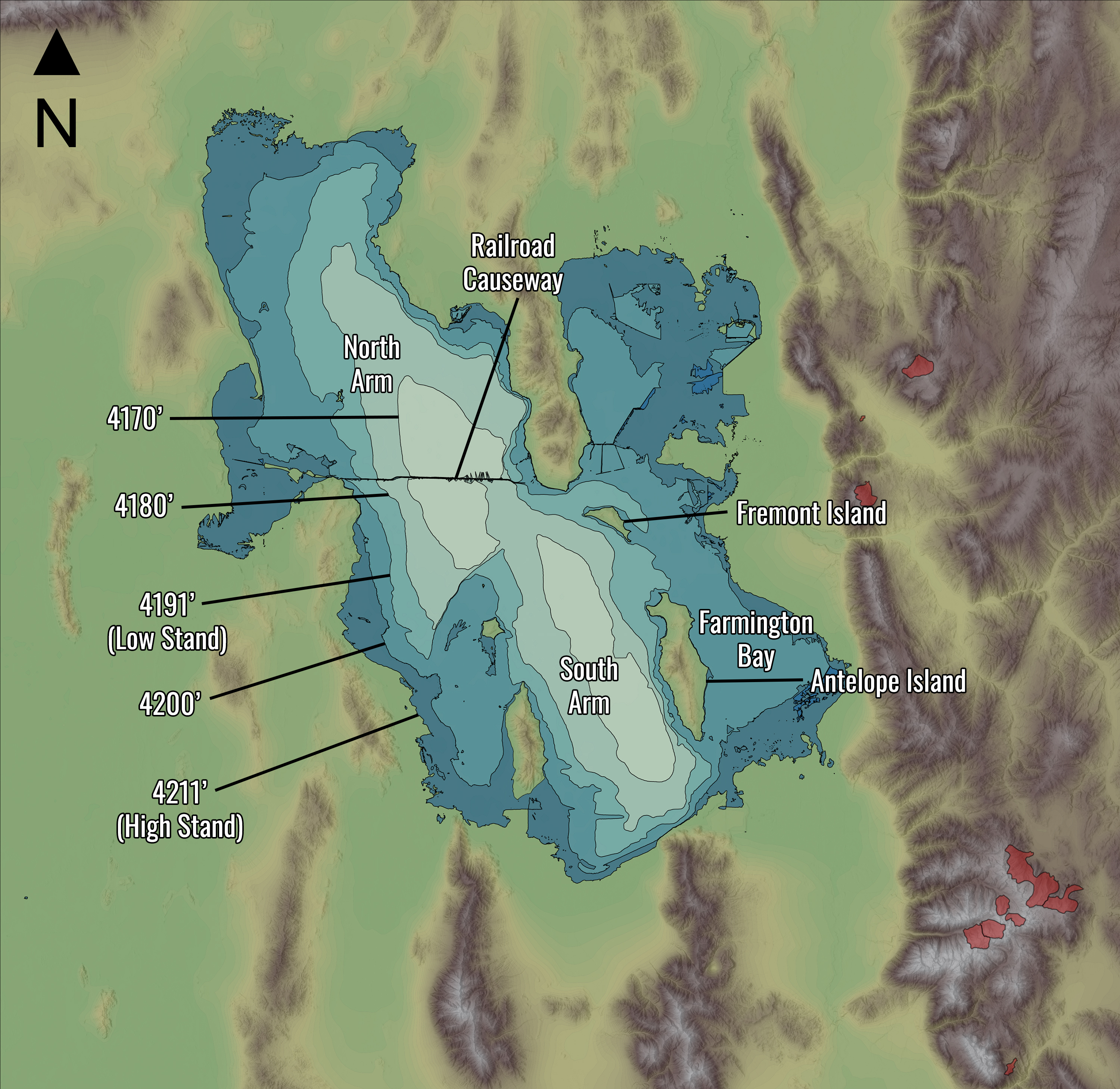

At about 4170 feet, the lake becomes two salt ponds.  That may sound crazy, but the lake is currently down about 20 feet from its most recent high stand in the late 80s.  Another 20 feet and we are there. 

The Modis image below was taken on September 27, 2021when the lake was near its minimum and historical low elevation.  It corresponds quite well with the 4191 foot contour above with a small arm of water wrapping around the north and east side of Fremont Island and a sliver of water along the Jordan River as it flows through what was formerly Farmington Bay to the east of Antelope Island.  


The implications of the withering Great Salt Lake are more dust, less lake-effect snow, and the demise of one of the most important bird habitats and ecosystems in western North America.  

Tuesday, April 26, 2022

The Weather Whiplash of the 2021/22 Season

I hope you enjoyed the Gift from the Gods last weekend.  What a long strange trip this season has been.  It was the best of times.  It was the worst of times.  Weather whiplash for sure.

I'll summarize with the Snowbird SNOTEL measured snow water equivalent (SWE) of the snowpack.  At this elevation, the season got off to a good start with SWE increase of 4.7" from October 8 to October 27.  

Then the spigot turned off and we only added 1.3" from October 27 to December 9.  The snow faceted on the north half of the compass, forming a persistent weak layer that would haunt us for a significant part of the winter and in many areas melted out on the south side.  

The storm track returned in December and Mother Nature added 15.7" of SWE to the snowpack through January 7.  That was a pretty good run and the only period outside of October that the snow accumulation rate that exceeded climatological expectations [i.e., the slope of the median (green) line] for more than a few days.  

We then lived on that snow until early March.  From January 7 to March 5, Mother Nature only added a scant 2.1" to the snowpack.  I have heard rumors it was the least snowy February on record at Alta.  I haven't seen the numbers for Alta Guard yet, but before this year, the minimum there was 34" and the resort reported 26" based on their snowfall history page, so chances are we set that dubious record.  

From March 5 through today, we've seen a series of storms interspersed with ablation (snow loss) events.  The SWE trace (black line) during this period shows ups and downs.  In the net, the SWE increased about 10.2" during this period, a rate that was still less than median for the period.  However, if my calculations are correct, the Snowbird lost 2.4" of SWE during those ablation events.  Without those losses, the accumulation for the period would have been 12.6", very close to the median SWE increase for the period of 13.1".  

I see that period from March 5 to April 25 as perhaps an example of the future Wasatch spring snow climate, with the snowpack ripening earlier, significant losses occurring on south aspects, and the frequency and severity of ablation events on north aspects increasing.  

My grade for the season is an incomplete.  I'd like to give it a C+, but due to a foot injury, I haven't done much skiing other than groomers since early February and had to sit out the storm cycle this weekend.  Thus I lack the ability to properly asses the season and encourage you to input your grade and justification in the comments below.  

Thursday, April 21, 2022

Gift from the Gods

The next three days are going to be exciting and interesting for weather and snow lovers as a major spring storm moves through the region.  

Today a surface cold front slowly sags into and intensifies over the Great Basin.  The GFS forecast valid 0000 UTC (6 PM MDT) this afternoon shows the front extending across central Nevada and northern Utah very near the Salt Lake City.  For much of the day, we will see strong southwesterly pre-frontal flow, possibly with dust (I assume you haven't had enough of that).  

The northern Wasatch Front will probably see a shift to westerly or northwesterly flow late in the day, but it's unclear if that will happen in the Salt Lake Valley.  Right now I'd say the odds favor that not happening, but I can't rule it out, especially for the northern part of the valley.  It will, however, be a dry front this afternoon, so the main impact will be on winds and temperatures.  

The models differ on the exact movement and position of the front overnight, although they keep it over northern Utah.  The GFS forecast valid 1200 UTC (0600 MDT) Friday morning has a disorganized surface front over northern Utah with the precipitation band to its northwest is filling in nicely.  The flow at upper levels and for the central Wasatch remains strong and out of the southwest. 

On Friday, the GFS does two things.  First, it develops widespread showers ahead of the frontal precipitation band by 1800 UTC (1200 MDT).  At that time, the frontal band is moving into northwest Utah and its leading edge is over the West Desert.  Note the accompanying surface wind shift in the lower right-hand panel below.    

That afternoon, the frontal band moves in and the flow shifts to northwesterly, with widespread precipitation over most of northern Utah by 0000 UTC (1800 MDT) Friday.  

Friday night is the post-frontal crap shoot with mountain induced precipitation over and upstream of the Wasatch Range and a chance of a little lake-effect involvement. 

By and large, Saturday looks like a gift from the gods.  Our GFS derived forecast for upper Little Cottonwood shows a total of 1.35" of water and 18" of snow for Alta-Collins through 9 AM Saturday, with some additional precipitation during the day.  

The ECMWF model is just a bit below that.  By 23/18Z (1200 MDT) Saturday the SREF has 3 low members under five inches to give one heartburn, but 18 out of 26 members generate 10 inches of snow or more.  

Make some turns for me. 

Tuesday, April 19, 2022

A Quick Update

It's been a while since I did a post, but I've been busy working on the 2nd Edition of Secrets of the Greatest Snow on Earth.  It's coming along nicely and I'm hoping to get it to my publisher by the end of May.  

I have good news and bad news on the forecast front.  The bad news is we just had a frontal passage in the Salt Lake Valley and it has come loaded with dust.  

The moisture lags the surface front by a good ways and is pretty scant at that.  We'll see a few valley showers and mountain snow showers later this afternoon or evening, but the latter won't add up to much. 

The good news, however, is that the system coming in late Thursday night/early Friday morning and affecting us through Saturday looks more potent.  Below is the downscaled NAEFS plume showing some healthy totals with a mean of between 20 and 30 inches.  

Don't bet the house yet.  The GFS is a bit more subdued (and it tends to be wet), with just over an inch of water and about 16 inches of snow.  Regardless, keep your fingers cross for another April dumpage, just in time for the weekend.

Wednesday, April 13, 2022

Bits and Pieces

It's been a pretty good April storm cycle so far.  Totals at Alta Collins per automated measurements:

4 PM Monday 11 April - 4 AM Tuesday 12 April: 11 inches
4 AM Tuesday 12 April - 4 PM Tuesday 12 April: 2 inches
4 PM Tuesday 12 April - 4 AM Wednesday 13 April: 6 inches

I suspect the skiing was pretty good yesterday and will be excellent this morning where untracked.  The northern Wasatch also got hit pretty well.  Snowbasin is reporting 15 inches in the last 48 hours and has announced they will reopen for skiing Friday through Sunday.  It's never over until it's over.  

I'd like to summarize the forecast through Friday afternoon as "dribs and drabs" but that seems unfairly discouraging for April, so I'll say "bits and pieces" instead.  Currently radar shows snowshowers moving into the northern Wasatch from the west.  


This general pattern will continue this morning, with the northern Wasatch likely to receive the most snowfall and the central Wasatch intermittently getting into the action. For example, the GFS shows westerly flow at 700 mb (10,000 ft or crest level) across northern Utah at 1800 UTC (1200 MDT) today with the heaviest precipitation in the northern Wasatch (color fill).  


Through Friday afternoon, a series of weak systems will move through northern Utah with the large-scale crest-level flow fluctuating between westnorthwest and southwesterly.  Expect periods of mountain snow through Friday with occasional breaks and snowfall heaviest at upper elevations in the northern Wasatch.  Temperatures will also be increasing, so getting on it quickly will be important as it is April and the sun has no mercy for fresh dendrites.  

The GFS-derived accumulated precipitation and snowfall graphs below for Alta-Collins shows the situation well with a pulse of snow this morning and early afternoon, then a break, then a couple more small pulses before a few inches Thursday night into Friday morning.  There's another brief period of snow Saturday evening.  


The timing and strength of these periods of snow can't be forecast precisely.  I guess the operative word for this pattern is unsettled, with conditions becoming more mild as temperatures rise (note the the warming trend on Mt. Baldy in the upper right panel).  

Enjoy it while it lasts.

Tuesday, April 12, 2022

Graupel is Good

 The storm delivered as forecast (I love to say that!) in most areas including 11 inches through 8 AM at Alta-Collins.  

Here at the University of Utah, the ground was sprinkled this morning with some beautiful graupel particles.  Below is an example of a pea sized, conical-shaped graupel particle outside the Student Life Center. 


Graupel forms as tiny supercooled cloud droplets collide and freeze on an ice particle.  Typically it has a higher fall speed than snowflakes (3 meters per second compared to 0.5 to 1 meter per seconds) and requires a fairly strong updraft to form.  Radar imagery overnight suggests that the convective cell moving over the University of Utah at 12:40 UTC (6:40 AM, see below) may have produced it, although there were one or two other cells that moved through the area earlier.  

We are now solidly into the unstable, postfrontal flow, although as shown in the time-height section below, the flow direction below and at crest level is predominantly westerly to west-northwesterly and perhaps not quite optimal for Little Cottonwood.  

Nevertheless, periods of snow will predominate today and, given the April sun, we will probably see some strong snow showers this afternoon, possibly with thunder and lightning.  Expect to seem some graupel or pea-sized hail as well.  My best guess is 3-6" more for Alta Collins, although the hit-and-miss nature of what we will see later means there's a wide range of possibilities.  A direct hit by a strong cell would really add up, for example.