Wednesday, April 11, 2018

Late Season Pow?

We are now moving into mid April where any possible powder day is a blessing from the heavens.  We have potential starting tomorrow.

The latest NAM shows a classic Utah spring storm scenario with an upper-level wave digging into the western U.S. and closing off over Colorado.  The latest NAM forecast for 0900 UTC (0200 MDT) tonight whows the upper-level trough extending from the BC coast to California (dashed lines, 500-mb height contours black) with a classic Intermountain cyclone centered over northern Utah and the trough extending southwestward to the high Sierra. 


At this time, not much is happening precipitation wise except in far northwest Utah.  Some strong southerly winds are possible, however, during this period, and the NWS has issued a high-wind warning for portions of western Utah.  Info below. 

As the upper-level trough pushes inland and the surface cyclone moves northeastward, we get into northwesterly flow and precipitation is expected to develop along the Wasatch Front and Mountains tomorrow morning.


Right now, it appears the lowlands will make it through the morning commute unscathed, but snow-levels will be dropping and the potential for bench and possibly valley snow exists during the day tomorrow.  The forecast below shows 700-mb temperatures (contours), winds (barbs) and 3-h accumulated precipitation for 2100 UTC (1500 MDT). 


The latest NWS forecast calls for snow down to the valley floors by mid-day Thursday. 


Given that this is a late season storm, the ground is quite warm, and the bulk of the storm for the valleys is expected during the day, accumulations will be largest on cold surfaces on the benches and more limited (or non-existent) over pavement.  Much will depend on elevation and precipitation intensity.  The snippet below fro the 8:47 AM NWS forecast discussion illustrates that this is an evolving forecast situation, with updates expected this afternoon.  Monitor official forecasts. 


For the mountains, if precipitation were to start early tomorrow morning, there could be a brief period of rain up to 7000 feet, but otherwise this looks like an all-snow storm.  The latest numbers from the NAM add up to 0.88" of water and 15" of snow by 0900 MDT Friday morning.  The later stages of the storm look quite cold, with temperatures at 11,000 feet falling into the single digits.


As usual, much will depend on the post-frontal crap shoot.  The time-height section below shows the winds shifting to northwesterly early tomorrow morning and a prolong period with the crest-level (700 mb) flow WNW to NW through about midnight Friday.  There is considerable moisture and mid-level instability during this period.  This is an environment in which significant snows can occur if the flow direction is right and moisture is available. 


If this was early February, I would expect that this would be a right-side up storm, but there could be some wildcards.  Tomorrow, with surface heating, we could see some strong convection and that's even possible overnight Friday.  This might produce periods of graupel, especially tomorrow afternoon and evening.  

I'm fairly optimistic about this storm and am going on personal powder alert tomorrow.  If snowfall rates are high, or we get a lot of graupel, a dusk patrol might be warranted tomorrow afternoon, with Friday morning having major April powder potential as well.  The former depends on timing and precipitation intensity tomorrow, the latter on how things go Thursday night.  Spring powder is all about synoptic possibilities.  Whether or not you get the goods or ski on a chundery mix depends on processes not resolved by today's models.  

Tuesday, April 10, 2018

Evolution and Revolution in Weather and Forecasting

If you visited a National Weather Bureau (now the National Weather Service) forecast office in the 1920s, you would have found a team of meteorologists, in all likelihood exclusively male, spending a great deal of time analyzing weather maps.

The Weather Bureau Forecast Office, Washington D.C., 1926 (Source: http://www.photolib.noaa.gov/htmls/wea01302.htm)
That didn't change through the middle of the 20th century, but since then, meteorology, like all of science, has experienced dramatic transformation.  Surface observations are now largely automated.  Remote sensing from space or using ground-based instruments like radars and wind profilers allow us to infer meteorological conditions without taking direct measurements.  Observational data is distributed and processed nearly instantaneously.  Forecasts are produced by suites of numerical models, some running as frequently as every hour. 

As a result, the role of forecasters and meteorologists has changed dramatically.  Today, National Weather Service forecast offices don't look like the one above.  They look like the one below.

Source: NOAA/NWS, Norman, OK
Contrary to fears, automation and innovation haven't resulted in fewer meteorological jobs, but instead job growth that is expected to continue in the future.  The Bureau of Labor Statistics, projects a 12% growth in jobs in the atmospheric sciences from 2016-2026, faster than the average of 7% for all fields (see https://www.bls.gov/ooh/life-physical-and-social-science/atmospheric-scientists-including-meteorologists.htm). 

I bring this up because the Alaska Daily News recently ran an article discussing how humans who launch weather balloons are being replaced by automated facilities developed by Vaisala.  

Several groups and individuals have raised concerns about this change.  Some of the concerns may be justified and some not, but it is important for today's students to realize that the way we do things today is not the way we will do things in the future.  It is inevitable that humans will no longer launch weather balloons in the future.   That job will be taken over by either automated systems, or advances in remote sensing using radars and microwave radiometers that will allow us to profile the atmosphere without the need for instruments dangled from a balloon.  This is already happening from both space and ground based systems.  

A pessimist would say that meteorological jobs are doomed, but a more realistic and optimistic perspective is that meteorological jobs will evolve.  Meteorologists know better than most the perils of prediction, but one thing that is sure to happen is innovation-driven change.  The future is bright for those who prepare for the jobs of tomorrow instead of those of today.    

Monday, April 9, 2018

Perspectives on Outlier Conditions

Humans have a difficult time grasping events that our outside their range of experience.  I learned a lesson in that yesterday. 

Interested in exercise and seeing the aftermath of the remarkably warm storm on Saturday, my partner and I opted for a short, low-angle ski tour above Alta.  What we found was a remarkably stout and slick rain crust between above about 9200 feet to where we opted to quit climbing at 9500 feet.


This is the type of rain crust that I recall from my youth in upstate New York.  Essentially impenetrable by skis.  In this case, it was about 1 cm thick, with the snow below that still setting up.

Meanwhile, it was graupeling and at the time it was 0 to 8 cm deep, with the variability due to wind transport on the very slick surface.

We opted to head back down, skiing a low angle line.  Certainly what I thought was a very low angle line.  However, as my partner descended, the graupel began to sluff.  I shouted to him and he skied into the pucker trees on the right without incident.  I then watched the slough slowly slide downhill and eventually descend into Toledo Gully.

Here's the upper portion of the slough.  I measured the slope angle at this location at 20 degrees.  I didn't skin back up to check the starting location, but visually, I don't think it could have been steeper. 


As the slide continued downhill, it entrained snow above and within Toledo Gulch, a narrow terrain trap that bisects the skin track to Cardiff Pass.  The photos below were taken by a solo skier we encountered on our way down, posted to the Utah Avalanche Center site. 


The debris pile at the toe (pictured directly above) was more than deep enough to bury someone.  The solo skier did a beacon search at both the crossing point of the skin track, where there was a small debris pile, and at the toe, which we repeated in his wake just to be sure.  Fortunately, nobody was on the skin track at the time. 

Several observations posted to the Utah Avalanche Center site yesterday evening describe highly unusual avalanche conditions for the Wasatch Range, with slides initiated on remarkably low-angle slopes and running unusually long distances.  One experienced observed commented that "I have never seen snow slide so easily on low angle slopes."

A few years ago, Bruce Tremper wrote a blog for the Utah Avalanche Center that included a graph based on Swiss data showing the slope steepness for 1000 human triggered backcountry avalanches in which the slope angle was measured.  As can be seen below, human-triggered slides on slopes below 30 degrees comprise 3% of the sample (Note: This is the maximum angle of the bed surface that is 10x10 meters in size). 


The graph above is likely a curve fit to the data, which yields a smooth graph sometimes described as a bell curve, "Gaussian", or normal distribution.  On the left and right sides of such a graph are the so called tails of the distribution.  These are events that are rare and comprise a very small percentage of human-triggered avalanches.  Avalanches on slopes less than 25 degrees are well out the long skinny tail of the distribution.  In other words, rare. 

That distribution is, however, merely a statistical summary of past human-triggered avalanches.  Mother Nature does not care about statistics.  She cares about physics.  Yesterday we initiated an avalanche on a low-angle slope.  Unusual, but clearly possible based on the conditions that were present yesterday.

It is hard for humans to deal with outliers along the tails of the distribution.  Most of our experiences occur within the fat portion of the distribution.  This is true not only with regards to avalanches, but many other hazards we encounter in life.  It is very common to hear survivors of natural disasters saying things like "we've never seen a <insert phenomenon here> like this before." 

Yesterday was a valuable lesson in outlier conditions outside my range of experience.  Sharing stories about experiences like this is one way to build up a knowledge base that goes beyond individual experience.  Stay safe out there.

Sunday, April 8, 2018

What a Long Strange Trip It's Been...

In many ways, yesterday was a remarkable day meteorologically, but precip totals were a bit lower than forecast by the models.  Perhaps that's a good thing.

On the remarkable side, yesterday morning's sounding tied for the highest April precipitable water in the Salt Lake City upper-air period of record with 0.77 inches.  Surely we were higher than that in the late morning and early afternoon, but soundings occur at 1200 and 0000 UTC (6 AM and 6 PM MDT, although the actual launch time is a bit before then) and thus missed out peak moisture.  Sadly, there used to be a network of GPS sensors used to estimate precipitable water at high frequency (yes, you can do that with GPS), including one in Salt Lake City, but it seems to have had the plugged pulled as I can't find the data anywhere.  If anyone knows if that data is available and what the link is, please pass it along.

Rain was delivered, but the precipitation band shifted southward into Utah County pretty quickly.  Thus, after a few hours of steady soaker, it was over.  Convection during that period was limited.  No thunderstorms to really get things going (although there were some convective showers in the evening).  I'm not rooting for floods, but some rumbles would have been a nice.

I don't know if snow levels pushed all the way to 11,000 feet, but the Utah Avalanche Center reported rain to at least 10,400 feet.  Water totals for the last couple of days are now around 1.75" at Alta Collins.


There was some snow to start and it is snowing again this morning, but a good chunk of that fell as rain.  Intrepid UAC forecasters Drew Hardesty and Zinna Wilson braved yesterday's liquid sunshine and here's how things looked.

Their video reminded me of my times in the Cascades.  Note how these wet rain-on-snow slides can move slowly, but they are dense and have tremendous momentum.

Temperatures dropped overnight and it's now snowing again at mid and upper elevations.

As far as this winter is concerned, lately it occurs to me, what a long strange trip it's been.


Saturday, April 7, 2018

Cascadian Day Ahead

Humid and overcast this morning, with a puddle of haze along the valley floor
Saturday has dawned humid and overcast with a more Cascadian-like feel than we are used to around here.  The morning sounding from the airport showed a "juicy" environment, with near-saturated conditions through the troposphere and a precipitable water of 0.77 inches, which ties the highest observed in the record at KSLC for the month of April.

Source: SPC
Note in the photo above the puddle of haze along the valley floor.  As can be seen in the sounding, there is a shallow inversion present with high humidity, which leads to haze as some of that water vapor condenses on aerosols (i.e. pollution) from the valley floor.

The dewpoint (blue line below) has climbed steadily over the past three days and from yesterday through this morning has hovered around 45˚F.

Source: MesoWest
With so much moisture around, you might be wondering why it is not raining right now (about 9 am). The answer is that right now there's no dynamics, meaning something to lift the air so that it cools, resulting in condensation and the formation of precipitation.

That all changes late this morning with the approach of the cold front, which at 1500 UTC (0800 MDT) was draped across northern Nevada.


In fact, if you want to see a really juicy sounding, check out the one below from Elko, which has a precipitable water of 0.84".  That is the highest ever observed in the period of record at that site between November and April.


And that is what is coming to Salt Lake and environs today.

Turning our attention to the mountains, total precipitation (water equivalent) at Alta Collins and Snowbasin Middle Bowl from 6 AM MDT yesterday through 8 AM MDT this morning was about 0.85 and 1.2 inches, respectively.  Most of that precipitation fell as rain in the low-to-mid elevations or as very wet snow at upper elevations. 

This morning, the Utah Avalanche Center reported a 9300 foot snow level in the central Wasatch.  At 8 AM MDT the freezing level was sitting near about 9700 feet with temperatures of 32˚ at Alta-Collins (9662 ft) and Solitude Summit (9641 ft).

Two things will cause the freezing (and snow) levels to climb this morning, one is daytime heating, the other is the transport of warm, humid air into Utah by southwesterly flow ahead of the cold front.  The NAM shows 700-mb (10000 ft) temperatures climbing from -0.8˚C at 6 AM MDT to 3.9˚C by 3 PM MDT.  Thus, if you go out this morning thinking you'll be skiing in the snow at upper elevations, think again.  Snow levels look to peak near 11,000 feet this afternoon during the warmest part of the storm.

The numbers below from the 12Z NAM for the Alta area pretty much tell the story.  Note how the wet-bulb zero level (i.e., the height at which the wet-bulb temperature is 0ºC) rises from 9500 feet this morning to 12000 feet at 2 PM.  Snow level is typically about 1000 feet below this level.  You do the math.  It ain't good.  It remains above 10000 ft through 8 PM, when it begins to drop, along with precipitation rates.  Sad!


Our estimated temperatures for Mt. Baldy (11,000 ft) peak at 36˚F.  Simply incredible.  Total water equivalent from 8 AM to midnight is 1.02", with one measly inch of snow at Alta-Collins (9700 feet).

This afternoon will be highly unusual by historical ski-season standards, with incredible warmth and rain to remarkable elevations.  

Friday, April 6, 2018

A Saturday Soaker That Is Simply INCONCEIVABLE!!!

My meteorological excitement factor is relatively elevated today compared to where it has been much of the winter, mainly because of expectations of a strong frontal system pushing across the western US through tomorrow.

Right now we are getting just a bit of an appetizer.  The analysis below is for 1200 UTC (0600 AM) MDT and shows a weak 700-mb trough approaching Utah (brown dashed line).  With this system is a slug of moisture, valley rain showers, and upper-elevation snow showers.


After the remarkably low dewpoints earlier this week, the humidity just hit me in the face and felt so good when I walked out the door this morning.  The meteogram below shows how dewpoints (blue line) have climbed from the low single digits on Tuesday to 46 this morning.  Good for the skin!


It's warm, with temperatures of 34˚F at the base of Alta (8560 ft) and 36˚F at Snowbasin Middle Bowl (7402 ft).  The 8000 ft snow cam at Snowbasin shows about 1.5" of wet snow this morning.  I suspect it is raining at the base.  It's a garbage bag morning if ever there was one.  


Precipitation will taper off after 1800 UTC (Noon MDT).  Then, overnight, Mother Nature revs up the system for Saturday.  At 0600 UTC (Midnight MDT), a deep, 975 mb low is located off the Pacific Northwest coast.  It's a powerful, well developed system.  Ahead of the cold front, northern California, especially the mountains, get considerable rain.  At this time, the warmth of the storm is remarkable with 700-mb temperatures near +4C.  Perhaps only the upper elevations of Mt. Shasta will be seeing rain snow at this time.  Such a waste of water.   


The cold front then pushes inland and redevelops over Nevada.  At 1800 UTC (noon) Saturday, it's forecast to be located over eastern Nevada.  Note the disortion by the Sierra Nevada, as is common, and the lack of precipitation over southern Nevada and southern Utah.  The action is instead concentrated over far northern Utah where the remnant warm front can do its thing.  


The cold front pushes across northern Utah Saturday afternoon [forecast for 2100 UTC (3 PM MDT) below].  I expect for the valleys, the front will bring a pretty good deluge, with a possibility of thunderstorms and locally heavy rain.  It is, however, a fairly mobile feature and moves quickly across the state with precipitation winding down in the evening in Salt Lake.  


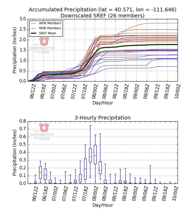
The forecast above is from the 0600 UTC initialized NAM.  Let's look more braodly at the possibilities based on our downscaled precipitation estimates from the SREF.  For the Salt Lake City airport, one sees this morning's precipitation, then the afternoon and overnight break, with a couple of members producing showers here or there.  Precipitation chances increase tomorrow morning and all members produce rain tomorrow afternoon.  Mean accumulations with the front are about a half an inch, which is a pretty good for a fast moving front in this part of the world.  The box-and-whisker plot below shows the period of strongest precipitation from about noon to evening (although timing could shift some between now and then).  
Shifting to the mountains, let's first talk about water totals.  In my view, the the pre-frontal period is perhaps the biggest wildcard.  Much will depend on the moisture plume, flow direction, and intensity of the forcing.  The northern Wasatch are likely to get more from that period than the southern.  Everyone should get a pounding with the front.  At Alta-Collins, the SREF mean puts out a bit over an inch of water.  The range, after deducting today's totals, ranges from about 0.5 to 1.7 inches.  The latter would be a big water total for about a 12-hour period.  I would not be surprised to see an hourly accumulation of more than 0.3 inches of water at Alta-Collins tomorrow afternoon.  

This is, however, going to be a warm storm.  Remarkably warm.  The NAM forecast for 2100 UTC (1500 MDT) tomorrow shows us sitting at +4˚C.  I'm not sure if I've ever seen heavy frontal rain in early April with such a high 700-mb temperature.  Someone should dig through the records as my memory is not as sharp as it used to be.


If we look at the numbers from the NAM at Alta, the wet-bulb-zero level tomorrow is over 10000 feet, reaching as high as about 12,000 feet from 11-3 PM.  


If that forecast verifies, we are going to see heavy rain perhaps all the way to 11,000 feet at some point tomorrow afternoon.  

I'd like to see some analysis of the past records to see if my gut reaction to these numbers is accurate, but this forecast makes me feel like Vizzini in the Princess Bride, "INCONCEIVABLE."


The GFS is a bit cooler, but I think we need to expect heavy rainfall tomorrow to elevations at least as high as 10,000 feet.  This is the definition of an outlier event.  Expect the unexpected.

Addendum @ 9:15 AM Friday

I feel the need to add a bit more to this post.  The forecast sounding from the NAM below for 2100 UTC (3 PM MDT) Saturday is simply unbelievable.  Fully saturated through the entire troposphere.  A precipitable water of 25 mm (about an inch).  That's monsoon-like moisture with a midlatitude front the likes of which appear unprecedented.  
Let me show you just how just out unprecedented such moisture would be, the yellow dot indicates where that sounding would sit in the sounding climatology for Salt Lake City.  We have never observed a precipitable water above 0.8" in April.  The forecast is for 1.0"!


It's a good thing this will be a short-lived event.  Even still, the potential for heavy valley rain is real and in the mountains I would expect the unexpected.  This is a Cascadian rain storm coming to Utah.