
The surface cold front passed the airport last night at a bit before 1 AM MDT as denoted by a 5F or so drop in temperature and a veering of the winds from southerly to WNW. Look carefully in the top plot below for the abrupt drop in temperature and rise in dewpoint and humidity.
 |
| Source: mesowest.utah.edu |
And so the endless summer of 2024 came to an end. Although we could be flirting with the upper 70s again next week, we'll call that fall or autumn, whichever you prefer.
Showers and then widespread precipitation then moved into northern Utah with the precipitation in the early morning hours being more widespread than I anticipated yesterday. That's a good thing as we have had little to no precipitation for over 3 weeks and this is beneficial precipitation to saturate soils and settle down the Yellow Lake Fire.
As of 7 am, the snow line is sitting somewhere around 9600 feet. Alta web cams show the white stuff covering the ground above 10000 ft.
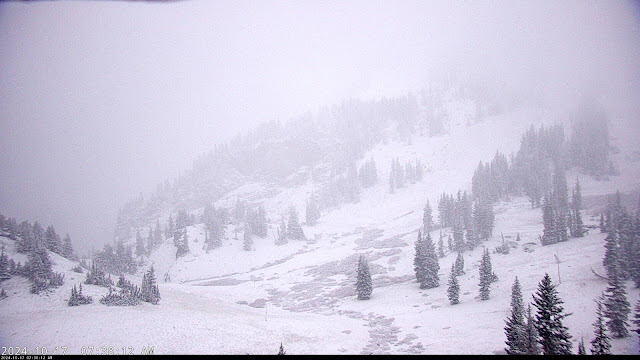 |
| Source: https://www.alta.com/weather |
But the High Rustler Cam shows the snow line just a bit off the top of the run, which is at 9800 feet.
 |
| Source: https://www.alta.com/weather |
And one can see a trace of snow on the snow stake at just over 9600 feet.
 |
| Source: https://www.alta.com/weather |
I put snow line in italics above as I consider that the level at which snow is sticking and accumulating on the ground. This is different than snow level, which is the level down to which snow is falling. This time of year, they can be different given the warm ground.
Radar and the models suggest we'll see precipitation for a bit more this morning, then more scattered showers with a possible break before the main trough moves in later today and tonight. A look at the HRRR forecast for the wet-bulb zero level shows it falling gradually to about 8500 feet by 6 PM this afternoon and then dropping abruptly to 5500 feet from about 10 AM to 2 AM as the main trough approaches. Thus, we will probably see snow levels dropping to 8000 feet today before it drops to near bench level tonight.

Much could happen tonight as the main trough approaches Utah. Through 7 AM this morning, the HRRR had produced about 1.5" for Alta-Collins. This is a bit ahead of reality (which is closer to 0.3") for that elevation, but might not be too bad at 10,000 feet. It then adds another 9" or so through tomorrow night. Given the crap shoot nature of what is going to happen as the upper-level trough approaches and closes off to our south, I'm going to stick with my 8-16" forecast from yesterday for Alta-Collins.
No comments:
Post a Comment