I don't know about you, but I'm sick of the heat. I'd love to see a morning with a minimum temperature in the 50s so I can throw the windows open and let the cool air pour in.
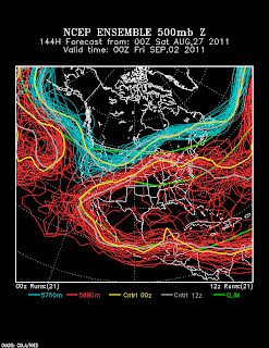
Thus, in addition to keeping an eye on Irene, I'm searching for signs of a cooler airmass. It's a ways out, but the 0600 UTC GFS is showing signs of the potential of a cold-frontal passage on Thursday.
The GFS ensemble members (from 0000 UTC) all put a trough over the west, but with a wide range of positions and amplitudes.
So, we can't count on it, but even a weak trough moving into would bring some relief, even if it just knocks temperatures down a few degrees and shuns out the monsoon moisture that is keeping our minimum temperatures so high. Let's keep an eye on the models and our fingers crossed.


And if you look out even further... great case of extratropical transition with a pacific Typhoon and then massive downstream development of a deep trough over the E. Pac. But that is really off in la-la land.
ReplyDelete