Posts

Update on the "Best Forecast (So Far) This Season"

Image
With about 2.5" of water and 23" of snow, the Best Forecast (So Far) This Season, which we discussed on Christmas Eve, is verifying well so far at Alta Collins.  The yellow dots are my best guess of where things stand as of 8 AM/15Z this morning showing us in the upper end of water equivalent and about in the middle of the Utah Snow Ensemble forecasts. For today, the 12Z HRRR is generating 1.25" of water and 10" high-density of snow from 8AM through 11 PM.  This is on top of the couple of inches that it was producing from 5-8 AM earlier this morning, which appears to have verified nicely.  I like another 6-12" of high-density, upside-down snow before this storm winds down this evening. Note that with the KMTX radar out, this is even more of a guess than usual. Did I say high density and upside down?  It's a warm storm though, and getting warmer.  I suspect snow levels this afternoon will be pushing 7500 feet. They may go higher than that this evening if the...

The Best Forecast (So Far) This Season

Image
'Twas the night before Christmas when all through the house Meteorologists were stirring, along with the mouse The forecasts were hung by the chimney with care In hope that deep powder, soon would be there Now is not the time to settle your brains for a long winters nap.  The latest forecasts from the Utah Snow Ensemble are the most optimistic I've seen all season for the central Wasatch, although that admittedly is a low bar.  Ignoring the outlier minimum and maximum forecasts, there is a tight clustering of forecasts producing  2.04 to 4.73 inches of water and 25 to 58 inches of snow for Alta-Collins by New Year's Day.   The first storm comes in with Santa's sleigh tonight, but excitement should be tempered with the fact that it's a splitter.  The GFS shows it to be a "full latitude trough" on the west coast this morning with precipitation extending from off the SoCal coast all the way up into British Columbia. But by Christmas morning it's split, al...

Snowpack Update

Image
A rather unscientific polling of locals on a relatively small number of chairlift rides yesterday suggests that this year is off to a slow start.  Is that really the case? Yes. First we can look at the snowpack water equivalent.  Three of the SNOTEL sites with long-term records in the central Wasatch, Snowbird, Brighton, and Thaynes Canyon sit at their lowest or 2nd lowest water equivalents on record.   Source: NRCS The Snowbird site is near the Gad Restaurant, which is currently under construction.  Site notes indicate that the pillow was moved about a hundred feet on 20 December, and indeed there is a discontinuity in the record around that time with a drop in water equivalent from 4.2", which was near the lowest on record (since 1990), to 3.2 inches, which would be the lowest on record.   How much faith to put into the representativeness of the Snowbird measurements is unclear, but they don't paint a rosy picture.   Brighton is the 2nd low...

Another New Product from the Utah Snow Ensemble

Image
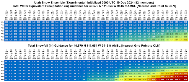
By popular demand, we now have a tabular output product from the Utah Snow Ensemble for Alta-Collins available at  https://weather.utah.edu/text/ensgefsdslccforecast.html .  This should provide access to the most recently processed run and provides tables of total water equivalent precipitation, total snowfall, 6-h water equivalent precipitation, 6-h snowfall, snow-to-liquid ratio, and wet-bulb 0.5C height.  Times are local (mountain) time.  Cells are color filled by magnitude.  An example of the first two tables is below. The row labeling for each table goes from the minimum value of the 82 ensemble members to the maximum value.  The P stand for "Percentile" so that P10 means the 10th percentile.  That means that 10% of the ensemble members are below that amount and 90% are above it.   P50 thus is right in the middle, or what statistical types call the median.  50% of the members lie between P25 and P75 (this was corrected from a typo t...

Do You Believe in Santa Claus?

Image
These are desperate times in the natural snow department.  I supposed it could be worse.  Alta has had 105" of snow so far this year and has a base depth of 37", but these are meager numbers for mid December.  Snowpack water equivalent is the best measure of the robustness of the snowpack and we are well below median for that metric at most high-altitude observing sites in the Wasatch including 50% of median at Snowbird, 56% at Brighton, and 43% at Thaynes Canyon.  Somehow, Mill D North sits at 104% of median. Good for them, but that's still only 5.7" of water.   The snowguns continue to blaze, but this is Utah, home of the so-called Greatest Snow on Earth.  Is there hope of a Christmas Miracle? The truth is that the ensembles are not giving us much love. Last night's Utah Snow Ensemble came in with most members under 0.5" of water at Alta-Collins for tomorrow's storm. A look towards Christmas shows that there are some members giving us the goods, but ...

A Welcome Storm

Image
The Alta snowstake cam suggests we're getting more action that may have been advertised by the models with perhaps 6-7 inches on the stake earlier this morning before the ski patrol wipe (kudos to my friends at OpenSnow for producing the Alta Snow Stake time laps so I could grab this image).  And then another inch was added since then (not shown).   The automated sensors are coming in a bit below that with about a 6" increase in the total snow depth and 6" on the interval board (ignore the spurious 34 reading at 08:00).   Those numbers are a bit higher than advertised by the HRRR and GFS over the past few runs.  Below are the forecasts for Alta-Collins going back to 0000 UTC 12 December for snowall amounts through 9 AM this morning.  Only one of the HRRR runs went for 6" and the most recent was only an inch.  The GFS was a bit more optimistic overall, but never got above 4.5 inches.   0Z 12 Dec HRRR: 1.1” 6Z 12 Dec HRRR: 6.0” 12Z 12 Dec ...

The Future Is Uncertain

Image
The physicist Niels Bohr once said that "prediction is very difficult, especially if it's about the future" and that is very evident when looking at the latest Utah Snow Ensemble (USE) plume for Alta-Collins.  The 82 members of the USE show remarkable spread for total water equivalent and snowfall over the next 10 days ranging from nearly zilch to about 2.5" water/38" of snow.   The period features three storm systems and the 82 members can't seem to show much agreement in the intensity and timing of snowfall associated with each of them.  We'll likely to be in a better place at the end of the 10-day period than we are now (it helps that the bar is set so low), but don't try to pin me down on details such as should I get a parking reservation at Alta for Friday, Saturday, or Sunday.  The first system moves through Thursday night and Friday, and the second Saturday night into Sunday, but I don't have any confidence concerning how much each of them...