Posts

Seasonal Stats Update

Image
Winter is over.  I repeat.  Winter is over. Meteorological winter that is, covering December to February.  I could talk about the snow to come, but the forecast has changed little.  Periods of snow for the forseeable future.  Enjoy.   So let's look back and look at some stats, starting with the Salt Lake City International airport.   The average temperature for this winter was 33.0˚F.  That slots in as the 49th warmest out of 149 winters in the period of record.  No biggie in that regard.   Source: https://xmacis.rcc-acis.org/ I get a lot of gripes about the observations from the airport, but if we look at Bountiful Bench, with complete records back to 1975, it rates as the 20th warmest out of 49 winters.  Still above median.  Basically, the winter hasn't been unusually cold or warm.  It's just a bit above median for temperature.   How about snow?  For this, I'll look at the period from O...
Oh What a Night!

Image
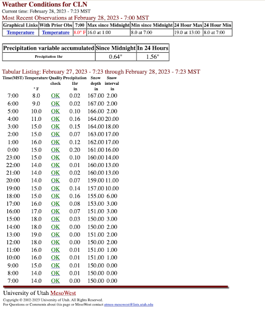
You can't stop Mother Nature this season.  More insane numbers from the Wasatch.  As reported by the Utah Avalanche Center this morning, storm totals for the PC Ridgline are now .95–1.05" water and 15–22" of snow and Upper Cottonwoods 1–2.5" of water and 16–35" of snow.  The Ogden and Provo area Mountains have also been blessed with big dumps.  Snowfall late yesterday was intense at Alta-Collins. Hourly snow interval observations show an increase in snow depth from 3 to 10 inches in two hours from 5 to 7 PM.  Normally the board is wiped between 4 and 5 PM, but I can't tell if that was done as the interval remained at 3 inches.  Given the intense snowfall rates, it is possible it was wiped and it basically was snowing 3" an hour starting at about 4 PM.    I've heard that the Cottonwoods were a mess during this period and that the overnight road closure was moved up to 8 PM.  If so, I suspect both were closely related to the heavy snowfall....

Unsettled

Image
I've never liked to used the adjective unsettled to describe the weather.  It always seems like a bit of a cop out.  But for the next few days, it might be the best option.   The large-scale pattern features the passage of three upper-level troughs across the western US over the next 4-5 days.  The first passes to our south today and is the remnant of the beast that has brought cold and snow to California the past couple of days.   The second isn't as deep, but brings with it a strong cold front that moves across Utah late Monday.   The third, evident just upstream of the northwest coast of the US in the plots above, is forecast to move across Utah late Thursday. Active would be another adjective that one could use to describe this storm period! The GFS-derived Little Cottonwood forecast shows what I'll simply call "periods of snow" from today through Tuesday Night with another pulse coming in Thursday night. The net total water equivalent fo...

More Good News for Powder Lovers

Image
I have a friend who likes to talk about BDOY or his Best Day of the Year.  Some seasons, the candidates for BDOY are limited, but not this one.   I had an amazing powder day yesterday in mid-elevation terrain outside of the fabled tricanyon area.  The coverage was better and the powder deeper than I've ever seen in that zone.  Hopefully blogger doesn't mangle the great video captured by my friend Colin. Was it the BDOY?  I have no idea.  I've had so many good days of backcountry powder that they all just blur together.   And I like what I am seeing in the medium range forecasts, which continue with the progressive pattern that brings storms to our area from the northwest.  There's not a lot of agreement on the timing and strength of individual systems, but overall, most the NAEFS members keep things fairly active through the start of March.   And if I courageously peak beyond that, the pattern continues to look favorable, altho...

Here We Go

Image
Super excited for the events to unfold later today through Wednesday.  The models continue to be on track with a major, all elevations snow event for Utah.   The large-scale setup for this event is an amplifying upper-level trough that digs southward along the Pacific Coast.  As discussed in an earlier post , this amplifying system is actually connected to the development of two powerful cyclones over the northwest Pacific, which amplify the immediate downstream ridge over Alaska, which in turn amplifies the trough along the Pacific Coast through a process known as downstream development.  The GFS forecast valid at 0000 UTC 22 February (5 PM MST Tuesday) shows all of these features nicely with the northwest Pacific cyclones marked with Ls, the ridge with a zig-zagged line, and the trough with a dashed line.   This is a highly dynamic situation with rapid amplification of the jet-stream pattern.  It is only through the power of numerical weather pr...

Will Snow Miser Bring Us the Goods This Week?

Image
If you've never seen the Rankin Bass Christmas Special A Year Without a Santa Claus do so soon as the epic battle between the Snow Miser and Heat Miser is not to be missed.   I thought of the Snow Miser today as I glanced over the model runs and thought he could bring the goods this week.  Cue music. I know it's not Christmas time but so what.  We are looking at the potential for a major, all elevations snowstorm late Tuesday and Tuesday night, with potential for things to linger into Wednesday, especially in the mountains. Things look to really get going late Tuesday.  Below is the GFS forecast for 0000 UTC 22 Feb (5 PM MST Tuesday) with a cold front and associated precipitation draped across northern Utah.   The beauty of this cold front is that as the upper-level trough digs along the Pacific coast, an intermountain cyclone forms along it, which slows its progress and causes it to pivot over northern Utah.  Below is the GFS forecast for 0600 UT...

Incoming?

Image
Presidents weekend and week are on our doorstep.  Brace yourselves!  Fox13 is reporting that the Salt Lake City International Airport is expecting Monday, the day after the All Star Game, to be the busiest day of the year.  It will be a busy weekend downtown.  I wonder if that will increase or decrease the usual holiday pulse to the mountains?  Time will tell.  On the weather side, storms are incoming, but with some forecasting issues that give me indigestion early next week.  Saturday looks dry, but a passing cold front and upper-level trough will bring a quick hitter storm Saturday night and early Sunday.   Then we transition into a moist northwesterly flow for Monday and Tuesday.  The GFS integrated vapor transport valid 0000 UTC 21 February (5 PM MST Monday) shows large vapor transport indicative of an atmospheric river wrapping clockwise from Hawaii around a high pressure system centered near 40˚N and then into the Pacific Northwes...