Posts

Irish and English Travels
Image
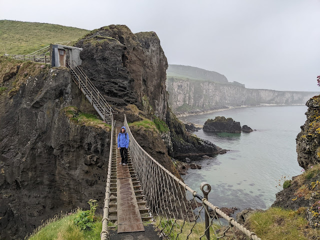
We dropped back into Utah last night after three weeks in Ireland and southern England.  Today is the first day I've used a desktop computer in three weeks.  It was a wonderful break!  I even tried to avoid using e-mail and removed my e-mail apps from my phone and tablet before going, but as soon as we got to Amsterdam our flight to Dublin was cancelled and they said "for updated travel information, check your e-mail."  So the first thing I did in Europe was install Outlook.  Lol.   Ireland was simply wonderful.  I had no idea what a lovely country it is. Although it lacks big mountains, the hills and coastlines are rugged and beautiful.  It was cool and showery too, which we absolutely loved.  I think the highest temperature we saw there was about 21˚C when we were in Belfast.  The rest of the time it was sweater and shell weather. I can't tell you how good it felt.   We did a full circumnavigation of the island, doing lo...
Blog Break

It's been a long 2+ years since the start of the pandemic.  I'm taking some downtime for the next few weeks.  Blogging will be very light to non-existent.  Enjoy the first month plus of meteorological summer.  

Snow Update

Image
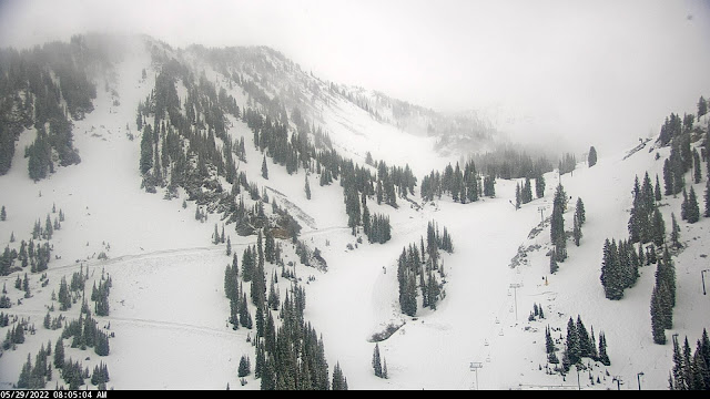
A soggy Sunday has settled in over northern Utah.  One could complain given that it is the holiday weekend, but we need every soaking we can get in these droughty times.   Alta is beginning to look wintery this morning.   Overnight temperatures fell at Alta-Collins to 31˚F as of 7 am.  Water equivalent precipitation since midnight is about 0.5", with no accumulation so far on the interval stake, although how well it is being maintained is unclear.   The web cam shows perhaps two inches.   Call it cream on crust.   The GFS has been pretty consistently calling for significant accumulations today, totaling 1.2 inches of water and, based on our snow-to-liquid algorithms, about 14 inches of snow from midnight last night to Monday afternoon.   There's a certain amount of crapshootedness to these spring storms given their scattered, convective nature, but perhaps we can get one last day of fresh out of this event.  I su...

Dismal Snow Situation in the Eastern Alps

Image
 It's looking like this past season was especially dismal for seasonal snow in the eastern Alps and I suspect by the end of summer it will have been one for the glaciers as well, if it isn't already.   The Zugspitze on the border of Germany and Austria is my bellwether as there's a very good web cam there and it is at an elevation where there once was a glacier, but no more.   This year looks to be a double whammy due to a "meh" snow season and the damage being done by Saharan Dust that was deposited onto the snowpack a few weeks ago.   Below is the view looking south from the Zugspitze yesterday.  The snow cover is already spotty and covered with the Saharan Dust, which increases the absorption of solar radiation and the snowmelt.   Source: https://www.foto-webcam.eu/ Below are images taken on the same day or prior day back to 2016 (also from https://www.foto-webcam.eu/), showing the especially poor snow coverage this year.  O...

Build the Trails, Part II

Image
When I first moved to Salt Lake City in the 1990s, purpose-built mountain-biking trails didn't exist near town, with the exception of the pipeline trail in Mill Creek Canyon, which I'm not sure was truly designed for mountain biking.  There was no Avenues Bonneville Shoreline Trail (BST).  I used to ride the fire road above Terrace Hills Drive and then hike a bike to the top of the Avenues Twin Peaks.  One could descend via that route or down the Bobsled or the Agony Escalator.   In 1998 a friend and I had been looking at topo maps and decided that we should ride to Rudys Flat above  Bountiful via ridge thats west and north of City Creek Canyon.  Looked "doable" on the map.  There was to TrailForks or other app to give us a trail report.  We left after work.  We road up the Ensign fire road past the various comms towers, which beyond the first set of towers was as bad then as it is today.  Then we started working our way out the rid...

Build the Trails

Image
It's prime season for biking and hiking in the Avenues foothills.  This year it seems especially lush and the vegetation is filling in nicely around the recently constructed trails. There could be more trails available to hike and ride, but trail construction was halted in May of last year .  This was allegedly a "pause" that would last until that fall.  Then it was extended to this summer.  In April, the city council further extended the pause until at least spring 2023 .   My views align with those of Ashley Patterson's in her op/ed in yesterday's Salt Lake Tribune .  The Foothills Trail System Plan included three years of public input.  Those surprised by the construction successfully pushed the city to pause completion of the project.  Some legitimate concerns were raised and the trails community supports addressing these.   On the other hand, we do not want to see trails construction stopped permanently or delayed significantly...

Cold Surge Coming

Image
 There's a pretty good cold surge expected to push into northern Utah later this week.  By Friday afternoon, yesterday's high of 88˚F will be long forgotten.   Below is the GFS forecast for 2100 UTC (3 PM MDT) Friday showing a short-wave trough moving through northern Utah with 700-mb (10,000 ft) temperatures near -8˚C.   The GFS-derived Little Cottonwood forecast shows temperatures on Mt. Baldy dropping from 43˚F tomorrow afternoon to 13˚F Friday morning.  Your Friday morning dawn patrol will feature slide-for-life conditions in the Baldy Chutes.   Right now, the system looks fairly dry.  The GFS produces only 0.13" of water equivalent with it on Friday at Alta.  There are a few members of NAEFS (11 out of 52) that produce more than 5" of snow at Alta Collins, but most are under 2".   Unless a low-probability snowfall occurs, the best recreation options later this week and weekend are probably at lower elevations.