Posts

University of Utah Curie Club

Image
This is almost a day late and a dollar short, but I want to give a shout out to the University of Utah Curie Club , which seeks to inspire women to pursue careers in science and reach the top of their field, and help women scientists balance family, scientific discovery, and the battle for research funding. I say a day late and a dollar short because I only learned of the Curie Club last night and the first gathering was yesterday.  However, they meet monthly and have an impressive lineup of discussion leaders for the 2016/17 academic year. Monthly gatherings are open to all undergraduate and graduate women in STEM (Science, Technology, Engineering, and Math) fields.

Newton Brings Steady Rain to Southeast Arizona

Image
Former Hurricane Newton continues it's northward movement and is moving through Sonora this morning on its way to southern Arizona.  A predecessor rain event lies across Arizona and New Mexico. As of 6 am MDT this morning, Newton had wakened to tropical storm strength with maximum sustained winds of 60 mph.  Still, he has held together rather well over the Gulf of California and State of Sonora.  Data coverage in Sonora is very limited, but one inland site near Hermosillo reported maximum sustained winds of 45 mph with a peak gust of 64 mph. Source: Mesowest The major impacts of Newton now will be rain and related flooding.  The National Weather Service has issued flash flood watches for southeast Arizona and southwest New Mexico.  As I write this, they have a flash flood warning out for the Nogalas Wash with nearby rainfall reaching as high as 1.25 inches in the past 24 hours. Source: NWS  As precipitation shields go, this one is about as ...

Hurricane Newton Aims for Tucson

Image
Hurricane Newton passed Cabo San Lucas early this morning, producing sustained winds at the CSLB7 observing site (735 feet above sea level) reaching 79 mph with a peak gust of 116 mph, both around 2 am MDT. Source: MesoWest Model forecasts call for Newton to weaken, but bring a strong slug of moisture into southern Arizona tonight and tomorrow.  The high-resolution NAM loop below shows the sea-level circulation center weakening but tracking across northwest Mexico, eventually reaching Tucson.  Southeast Arizona and New Mexico bear the brunt of the precipitation, especially tomorrow. There are multiple sources of uncertainty in precipitation forecasts related to landfalling tropical storms, but include (1) track and (2) the chaotic nature of convective storms.  The latter can lead to large spatial and temporal variations in precipitation, even over short distances (see also the Madweather blog ).  Last night's NCAR ensemble, for example, produced anywhere f...

Hints of Fall

Image
I don't want to overstate it as yesterday's high temperature was only 5ºF below average for the day, but it's nice to feel a hint of fall in the air.  Yesterday and last night were cool enough that we actually had to partially close the windows to keep the house from getting too cold.  That's such a nice change from the nuclear summer we've been experiencing. In the mood for further chilling, I decided to do a quick hike up Snowbird yesterday afternoon.  When time is limited, I've always found that to be a great workout with the added advantage of limiting wear and tear on my increasingly creaky knees. I had completely forgotten about Oktoberfest, so, in addition to the cooler air giving me a taste for the coming winter, I also got a full-blown taste of Little Cottonwood gridlock. Red Snake in September! The growth of Oktoberfest the past few years is quite astounding.  In fact, I don't know if I've ever seen more cars parked at Snowbird than I...

Frontal Flirtations

Image
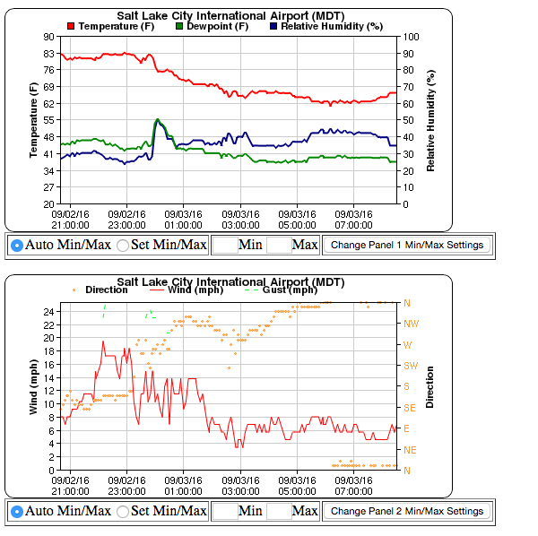
Weak fronts can be extremely difficult to pin down at night and in the morning when the nocturnal inversion that forms overnight tends to obscure larger-scale wind and temperature contrasts. Nevertheless, evidence of a weak front moving over the Salt Lake Valley can be seen in the meteograms at the Salt Lake City airport overnight.  Note how winds shift from southeasterly to northwesterly from about 2300 to 0100 MDT.  Without larger-scale forcing, the preferred flow direction at the airport overnight is southeasterly, so northwest flow is a dead give away that something is up. Source: MesoWest This morning, the MesoWest surface analysis at 0836 MDT shows northerly or northwesterly flow across much of the western Salt lake Valley, easterly flow near the University of Utah (consistent with overnight drainage and canyon flows).  Temperatures are generally in the low to mid 60s in that area.  In contrast, a number of stations in Utah Valley show southerly flow...

Just How Dry Was This Summer?

Image
Last night I awoke with a start to drops hitting the roof and leaves rustling on the windows.  My heart raced in anticipation of rainfall.  Alas, it wasn't to be.  A few sprinkles, some gusty winds, and it was over. Similarly, this morning teased us with an ominous sky, virga, and even some mammatus clouds. As I walked to the bus, I briefly felt raindrops on my face and arms.  So exciting!  However, hopes were once again dashed as the system moved off to the northeast. Just how dry has it been this summer?  Well, August 31 is in the books and we can now take a look back at all of meteorological summer (June, July, and August).  Total rainfall at the Salt Lake City airport was 0.67", making it the 11th driest all time. To put that into perspective, the histogram below shows the amount of precipitation falling in Salt Lake City by year back to 1874 ordered from high to low (I've left the years off since there are so many).  2016 is highl...

Gradual Cool Down Thankfully Coming

Image
Fall can't come soon enough.  Yesterday's high at the Salt Lake City airport reached 98ºF and was followed by a minimum last night (through 6 AM MDT) of only 74ºF.  Mother Nature really teased us last night as temperatures dropped quickly after 7 PM, but hopes of cool air pouring through the windows were quickly dashed as temperatures flatlined near 80ºF for much of the night. Source: MesoWest Today and tonight will probably be near repeats with a high near 98ºF and a low tonight in the mid 70s.  There is hope in the possibility of an isolated thunderstorm.  If you one of the chosen ones to receive rain and evaporatively cooled air, consider yourself fortunate. The good news is that a gradual cool down is coming.  The GFS 700-mb temperature and wind analysis and forecast loop below shows the slow movement of cooler air associated with the upper-level trough presently over the Pacific Northwest into northern Utah later this week into Saturday morning. ...