Friday, February 10, 2023

Steenburgh Winter Ends

What a Steenburgh Winter we have had this year.  We hit 100" for the first time at Alta-Collins on December 15th, giving us nearly two months with a deep snowpack and a low-angle sun.  With one exception, all of my ski tours after the November dry spell offered up freshies.  There are a lot of people ski touring today, so the ability to occasionally ski good snow on the south side of the compass on many days was greatly appreciated and enabled some creative ski tours.  

But alas, sun angle and day length are increasing, resulting in more and more solar energy input into the snowpack.  Slopes that were shady in December are now starting to see the sun. Only areas on or shaded by steep topography are still in winter darkness, as illustrated by the photo of Broads Fork below, taken a bit before solar noon on Tuesday.  

There's still good skiing to be had, and on average upper-elevation, north-facing terrain doesn't reach peak snowpack until late April.  Aspects on the north side of the compass can still harbor good snow days after storms. But February 10th marks the end of the crème-de-la-crème of low-angle touring season.  It is around now that the caustic influence of the sun becomes increasingly apparent with south aspects quickly damaged, even on cloudy days, and the range of aspects impacted by the sun on clear days increasing by the day.  Plenty of good powder skiing to be had still, but sun damage will become more common across a wider range of aspects and more quickly after storms as we move toward and into spring.  

Enjoy it while you can. 

Wednesday, February 8, 2023

Great Salt Lake Strike Team Report

The Great Salt Lake Strike Team issued a report today that serves as a resource for the 2023 General Legislative Session.  The full report is available here.  It's a little unfair to call it a report as much of the document is a visual summary with bulleted lists and highlights, which makes the key findings very accessible.  

Perhaps the most important insight is a clear summary of the causes of the record low lake elevation.  The largest contributor is human consumptive use, with declines in precipitation and runoff efficiency and increases in direct evaporation from the lake due to climate warming smaller contributors.  

As I often say, we have met the enemy, and it is us.  In the short term, finding ways to reduce human consumptive use is probably the most important policy lever for getting water to the lake.  The report recommends that we should leverage wet years to do this, and it was good to see that they highlight that this year, given our relatively healthy snowpack, represents a significant opportunity.  

Given how well laid out and succinct the report is, I refer you to the report for additional insights and recommendations.  

Monday, February 6, 2023

Complexities of Valley Cold Pools

As wonderful as the snow we have had since yesterday is (14" at Alta Collins as of 8 AM), what was really fascinating about this storm is how it affected the valley cold pool and associated pollution that has been resident over the Salt Lake Valley the past few days.  

The valley cold pool is the layer of cold air that resides in the Salt Lake Valley during what are known colloquially as inversions.  I prefer the term cold pool because not all inversion events feature a true inversion in which temperature increases with height (the atmosphere can still be quite stable when the temperature decreases slowly with height but is not inverted).  In addition, in some instances the inversion is elevated, so it is not really correct to call the cold air beneath it the inversion.  

OK, enough semantics.  Valley cold pools can be deep or shallow.  They can mix out quickly or slowly.  Then can be eroded by surface heating (which warms the cold pool) or from the top down by the wind. 

Observations from Hawthorne Elementary School at 1700 South 700 East over the past several days show the buildup of pollution over the Salt Lake Valley during the last work week, with PM2.5 levels peaking at unhealthy levels on February 3rd (Friday) and 4th (Saturday).  

Source: Utah Division of Air Quality

However, on February 5th, something odd happens.  First, air quality improves dramatically from about 3 AM to 9 AM when PM2.5 declines from 52 ug/m3 to 11 ug/m3.  Then, it jumps up again, in just one hour, to 49 ug/m3.  Talk about snatching defeat from the jaws of victory!  Then there is a gradual reduction through this morning, although some pollution remains at this location.  We still have not fully mixed out!

So what is going on?  With the approach of the storm on Sunday, the valley cold pool scoured out in much of the valley except the northern end and near/over the Great Salt Lake and environs where elevations are lowest and the coldest of the cold air was resident.  Lake temperatures are also quite low now, near 0˚C, so on a relatively warm, cloudy night, the air over the lake is locally cold.  As a result, we mixed out a good portion of the valley, but as seen in the photo below, taken toward the southwest and Oquirrh Mountains from the Avenues at 7:47 AM, a thin lens of cold air and pollution remained over the northwest valley (and likely over the Great Salt Lake and environs).  


I thought perhaps Mother Nature would be able to fully scour out that cold pool, but she had other ideas.  Instead the cold pool pushed southward and eastward that morning extending across a good portion of the Salt Lake Valley by 9 AM.  Hence the jump in PM2.5 concentrations at Hawthorne Elementary.  

Looking to the SSW from the upper Aves

A little while later, it started to snow.  Snow can remove some pollution from the atmosphere, but the temperature of the air aloft and the strength of the flow, which was rather weak, were not sufficient to crack and mix out the cold pool.  By 4:37 PM, the clouds were starting to move out, but the cold pool and associated pollution remained over a good portion of the Salt Lake Valley.  


Here are a two more photos showing the incredibly shallow nature of the cold pool and pollution as the sun set.


Even this morning, the cold pool and pollution refuse to give up.  Pollution levels for much of the east bench are mostly in the good category, but there are still a few pockets in the moderate category remaining, especially in the lowest elevations and west valley.
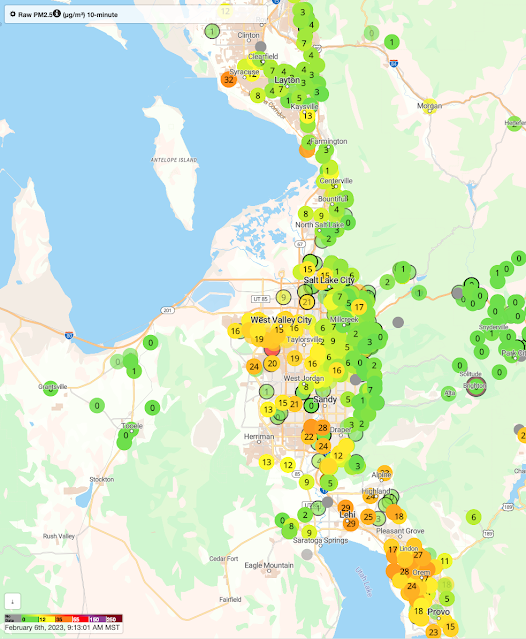
Source: purpleair.com

Better computer models and approaches are needed to forecast such complexities than we have today.  Simulating shallow cold pools is a major challenge and requires not only high resolution, but also very good information on the land surface conditions, snow cover, etc.  

Sunday, February 5, 2023

The Cardiff Fork Forbidden Land

Cardiff Fork contains a mixture of public and private lands.  In 2012, an agreement was reached between the US Forest Service and private property owners securing a right-of-way for recreationists to access Cardiff Fork (see this Salt Lake Tribune article).  Last fall, however, that agreement apparently met its demise, as reported by the Salt Lake Tribune.  

Like many, I have skied in Cardiff Fork for years.  Yesterday, however, as we ascended Cardiff Fork on a ski tour, we encountered a number of newly erected signs just before the Catchers Mitt slide path saying No Trespassing Private Road.  

This culminated in a fence blocking the road.  


Not wanting to make a bad situation worse, we elected to turn around.  After talking with a number of backcountry friends, it sounds like the signs and fence were installed on Thursday.  

I do not understand the historical or legal issues at play here, including whether this is a legal or illegal blocking of public access.  I am sharing it to make everyone aware of what is happening in Cardiff Fork so that you aren't surprised as we were.  

Addendum @ 9AM 5 Feb 2023

Some context from Salt Lake City Public Utilities Director Laura Briefer below via twitter:

Friday, February 3, 2023

The Air Sucks

There has been quite a ramp up in pollution over the Salt Lake Valley over the past three days. Trend charts for the DAQ observing site at Hawthorne Elementary on 700 East show we reached well into the unhealthy for sensitive groups category yesterday, with a PM2.5 peak of 48.7 ug/m3 at noon (maroon line). 

Source: UDAQ

Even the 24-h average moved into unhealthy category last night and reached at 38.8 ug/m3 at 6 am this morning.  

I generally anticipate that it will take 3.5 days for the 24-h average to get to the unhealthy for sensitive groups category, but in this event we did it in about 2.  Good work Utah!

This morning's sounding from the Salt Lake City airport shows that a strong inversion remains in place with temperatures increasing from -6.1C/21˚F at the surface to 4.8C/41˚F at 801 mb/6500 ft.   

Source: SPC

The sounding from yesterday afternoon showed that the mixed layer over the valley only reached 850 mb/5270 ft, so basically all the pollutants are trapped within about 1000 feet of the valley floor.

Source: SPC

A weak trough is moving through tonight that will cool temperatures some at mountaintop levels, but probably not enough to crack the inversion.  Real relief probably won't come until Sunday when a stronger system moves through. 

Wednesday, February 1, 2023

The Dreaded Inversion

Thanks to the active pattern that has dominated over the past several weeks, we haven't had much in the way of poor air quality so far this winter, but that is changing temporarily this week.

The setup was the passage of an intense but shallow cold front on Sunday, which dropped temperatures in the Salt Lake Valley to well below average.  At the Salt Lake City Airport, the min/max temperatures on Monday were 9/20 and on Tuesday 10/25, compared to a 30-year average (1991–2020) on those days of 10/25.  

At the same time, temperatures aloft have begun to climb as a ridge builds over the area.  Early Tuesday morning, temperatures on Mt. Baldy above Alta were about -2˚F.  This morning they are around 10˚F.  

A look at this morning's sounding from the airport shows a 4.2˚C (7.5˚F) inversion based at about 825 mb, or about 1500 feet above the valley floor.  

Source: SPC

As the inversion developed yesterday, pollutants began to build up in the valley.  I have friends visiting from Innsbruck and took them to Alta where we had a great day introducing them to the Greatest Snow on Earth.  However, a late afternoon trek out the High -T showed the pollution lurking below.  

Indeed, the time series of PM2.5 at Hawthorne Elementary shows concentrations rising into the low end of moderate air quality yesterday afternoon and then continuing to climb overnight to 25.5 ug/m2 before subsiding slightly to just over 20 in the early morning hours.  

A saving grace so far is that the event is young and the base of the inversion is elevated.  That means that instead of pollutants being trapped very near the valley floor, they are dispersing through a layer that is about 1500 feet deep.  The sounding above showed that the atmosphere was well mixed in that layer, at least for now.  

The GFS, however, forecasts the movement of an upper-level ridge over Utah over the next two days, with the ridge axis parked right over us by 0000 UTC 3 February (5 PM MST Thursday).  

This will warm temperatures aloft and strengthen and lower the inversion.  The GFS forecast sounding for 1200 UTC 3 February (5 AM MST Friday) shows a strong inversion based right on the valley floor.


Only a weak mixed layer is expected to develop Friday afternoon (not shown).  Thus, we will see increasing PM2.5 concentrations this week that I suspect will persist until Saturday.  An approaching trough may weaken and scour out the valley cold air on Sunday or Sunday night.  Let's hope it comes through and gives us a refresh of mountain snow.