Monday, March 28, 2022

A Blisteringly Hot Stretch for March

Although we didn't hit the 80˚F US unit psych point for maximum temperatures, the last three days have been blisteringly hot.  

Salt Lake City area weather records begin in 1875 based on observations collected in downtown Salt Lake City prior to the 1920s and the Salt Lake City Airport thereafter.  In terms of the mean maximum temperature and average temperature, the last 3 days were the warmest on record during 1-27 March.  

Source: http://xmacis.rcc-acis.org/

Source: http://xmacis.rcc-acis.org/

For minimum temperature the mean was the 2nd warmest on record, behind 1907.  1910 also had a warm 3-day period, although the observations in those years were collected in downtown Salt Lake City, not at the airport.  

Source: http://xmacis.rcc-acis.org/

Additionally, thin high clouds meant net longwave cooling was limited.  I didn't bother skiing this weekend, but the Utah Avalanche Center notes this morning that most mountain locations have remained above freezing now for nearly 4 days.  There are many reports of large wet avalanches, including naturals reported by snow safety teams overnight.  Simply incredible.  Below is one example.

Source: Utah Avalanche Center

Not surprisingly, there has been significant snowpack loss in many areas.  Below is the mean water equivalent of snowpack at SNOTEL sites in the Jordan basin.  It has dropped from a peak of 14.2 inches on March 24 to 12.4 inches today.  

Source: NRCS

Even the Snowbird SNOTEL has declined about 0.8".  I'm not sure if this is the result of sublimation, or an indication that the snowpack there has ripened and is already losing mass to melt, but it's never a good sign when upper-elevation SNOTEL sites are losing snow in late March.  

Source: NRCS

Nevertheless, the storm track returns this week.  The pattern looks more typical of late March and early April than the late May/early June like weather we have had the past few days. 

Thursday, March 24, 2022

Is Eighty Doable?

There's lots of chatter right now about the warmth this weekend and the potential of a maximum temperature at the airport of 80ºF on Saturday or Sunday.  That would be the earliest 80˚F on record.  The current first 80˚F was observed on March 31, 2012 [Note from Jim: This was corrected from 2021, which was an error].  After April 5, all days through the summer have record maxima at or above 80˚F.  

To do this, we'll take a look at forecasts produced by the National Weather Service National Blend of Models, or NBM.  The NBM is a system that takes forecasts from many modeling systems, puts them together in a big ensemble, and then applies statistical techniques to yield forecasts, including those of maximum and minimum temperature at locations like the Salt Lake City international airport.

The NBM forecast for the Salt Lake City airport is below.  The maximum (red) and minimum (blue) temperature forecasts for the next 10-11 days are presented in the left hand panel using box-and-whisker plots to summarize the forecasts derived from all the input model forecasts.  

Source: https://hwp-viz.gsd.esrl.noaa.gov/wave1d/?col=2&hgt=1&obs=true&fontsize=1&location=KSLC

For each day, the red box denotes the middle 50% of forecasts produced by the models. This is known as the interquartile range. For Saturday, the interquartile range of maximum temperature forecasts covers 77 to 81˚F.  A horizontal line in the box denotes the median forecast, which is right in the middle of all of the forecasts. For Saturday, the median is 79˚F.  The "whiskers", which are the thin vertical lines, denote lower and upper "extremes."  Only 10% of the forecasts are at or below the lower end of the bottom whisker and only 10% of the forecasts are at or above the upper end of the top whisker.  In this case the lower "extreme" is 76˚F and the upper extreme is 82˚F.  

Roughly half of the model-derived forecasts call for a maximum temperature at or above about 80˚F.  The other half are at or below 80˚F.  It could be that the actual median is a bit above or below 80˚F.  I can't determine this without access to more than this graph, but for the purposes of this blog post, we'll call that good enough.  

Sunday is also potentially an 80ish degree day.  The interquartile range on Sunday is 78 to 84˚F, with the median also sitting very near 80˚F.  

Source: https://hwp-viz.gsd.esrl.noaa.gov/wave1d/?col=2&hgt=1&obs=true&fontsize=1&location=KSLC

Assuming these NBM forecasts are reliable and unbiased, 80˚F would be the "over/under" for maximum on Saturday and Sunday.  

Ultimately, time will tell.  Both days look nice, although the southerly winds will be picking up on Sunday and that will raise the prospects for blowing dust.  

Wednesday, March 23, 2022

Another Last Day of Winter

Steenburgh winter never happened this year.  Meteorological winter ended on March 1st.  Astronomical winter ended on March 20th.  

However, today might have been the last day of winter at ski resorts in upper Little Cottonwood.  At least that's what we called it at Snowbird this morning where the life expectancy of chalky groomers is now no longer than a day.  For groomer, Regulator Johnson was really outstanding this morning.  

Temperatures today are climbing and they will continue to do so, with the usual nighttime interruption, through the weekend.  We will se snow again in the future, but the transformation this week is going to be dramatic.  Check out the National Weather Service Forecast for the Salt Lake City International Airport.  81˚F on Saturday!  81˚F!  

Source: NWS.  Downloaded 1:10PM 23 March 2022

That's insane.  The earliest 80 on record was recorded on March 31, and that was in 2012.  

We'll see what we hit on Saturday, but things will be changing and changing fast.  Don't forget to sunblock. 


Monday, March 21, 2022

Astronomical Spring Begins

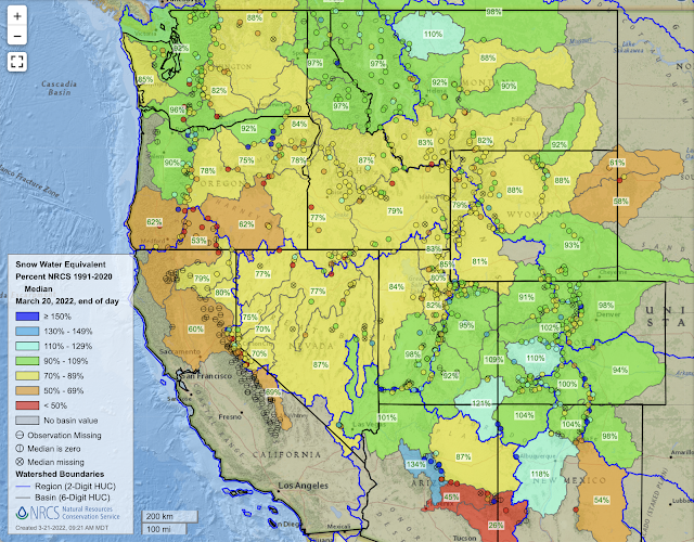
Astronomical spring began yesterday, so it is worth taking a moment to examine the snowpack situation across the west.

As you may recall, we entered March with the western snowpack generally at or below median in most drainage basins.  

Source: NRCS

For the most part, things haven't changed much over the past 3 weeks.  Some basins have climbed a bit closer to median (e.g., southern and eastern Utah, Colorado), whereas others have lost a bit (e.g., Washington, Sierra Nevada).  

Source: NRCS

Northern Utah basins now sit at 80-85% of median, compared to 71–80% on 1 March.  That's good, but still concerning.  For the Jordan, which includes the central Wasatch, we now sit at 13.8" of average water equivalent at SNOTEL stations compared to a median of 16.9". 

Source: NRCS

However, the situation is arguably worse than that for two reasons.  First, the green line above is the median daily water equivalent.  Because of differences in the timing of peak snowpack from year to year, it underestimates the median maximum water equivalent, which is the green x on the graph above and sits at 20".  The median date of that maiximum is April 8, so we have a lot of ground to make up with 2 weeks to go.  

This week will not help.  The dice are stacked for little to no precipitation through the 27th.  


It will also be warm.  Our GFS-derived forecasts show temperatures on Mt. Baldy about Alta (11,000') climbing through the week and peaking at 37˚F Saturday afternoon.  


So basically, this will be a warm, dry week with substantial losses of snowpack at low elevations and on sunny aspects.  

I'm hoping the trails dry out for valley mountain biking.  

Friday, March 18, 2022

Saharan Dust

A major multi-day Saharan dust event has ravaged the snowpack in the Alps and the air quality across parts of Europe this week.

Below is a composite MODIS image from Tuesday (15 March) showing a cyclone off the coast of Morocco with extensive dust streaming northward from the Sahara across Spain and France.  

If you think snirt (snow+dirt) is bad around here, check out the video below from Spain's Sierra Nevada.  

Dust coverage was extensive.  Here's a web cam from this afternoon at Mölltaler Glacier in the eastern Alps of Austria. 

Saharan dust events are not uncommon in parts of Europe, but this one looks especially severe.  In addition to making for a less-than-ideal ski surface, such dust does accelerate the spring melt by increasing the amount of solar radiation absorbed by the snowpack.  On the other hand, the dust also provide nutrients for ecosystems.  

Often such events are called sand storms, but sand particles are larger than dust particles and typically do not travel such long distances.  Thus, I prefer to call them dust storms.  Regardless of the name, they are not good for skiing.  

Tuesday, March 15, 2022

Barrieto Avalanche

I don't have much to say today.  Some periods of mountain snow beginning this evening through tomorrow.  GFS says 3" or so for Alta through Wednesday and most members of the downscaled SREF are under 2.5", although 6 of the 26 members go for 3-6.5".  

Nothing to get excited about.  

Footage of yesterday's skier-triggered avalanche on a run known as Barrieto in Mineral Fork is below (per reports, the skier was performing a ski cut and was able to avoid harm).  I'm not sure who to credit for the video or the photo below, but click here for the report on the Utah Avalanche Center site  I think it is the largest skier-triggered avalanche I've seen a video of from the Wasatch Backcountry.

Below you can see the full path with the crown near the Mineral Fork – Lake Blanche Fork ridgeline to the toe in the bottom of Mineral Fork.  

Debris covers a good portion of the Jeep/ATV road that switchbacks up through the base of the slide path and where there are often skin tracks heading up to Room of Doom.  A long time ago, a young man who was renting an apartment from our neighbor was killed by a natural avalanche in this general area while he was snowshoeing.  It was a tragic loss and I'm sure he had no idea what he was getting into on that stormy day.  I didn't really know him at all, but I think of him whenever I am skiing or driving by Mineral Fork.  

Climatology suggests that this time of year we are usually dealing with new-snow instabilities, wind slabs, issues related to warmth and solar heating, etc.  However, thanks to our long drought, we have a persistent weak layer that is not to be trifled with.