Friday, October 20, 2023

About Those Seasonal Forecasts

 NOAA released an updated seasonal forecast yesterday, which immediately got everyone in a lather with much of Utah being "in the green" for January to March precipitation.  


But let's all take a deep breath here.  First, these outlooks have never been very reliable (or all that useful for skiers).  Remember the outlooks from last season?  My "favorite" was the one issued by Accuweather last September.

That didn't age well in the Sierra and Utah that's for sure.  

Second, let's talk a bit about what the NOAA seasonal outlook actually means.  It is a probabilistic outlook, meaning that they are not forecasting those areas in green to definitely receive above normal precipitation.  Instead in the first two shades of green, they are saying that the odds are leaning to above normal.  For example, southern and central Utah are in the first shade of green, which means they are giving a 33–40% chance of above normal precipitation.  In any given season, if you have no idea what will happen, there's 33% chance of above normal, a 33% chance of near normal, and a 33% chance of below normal, so this is a very minor shift of the odds. 

But let's look a bit closer at the rationale behind the NOAA forecast.  Such forecasts are based in part on precipitation during prior El Nino events (this winter is expected to be an El Nino winter) and ensemble forecasts produced by statistical and numerical models.  Here's a snippet from the discussion issued with the seasonal outlook:

"Despite a strong El Nino event highly likely this upcoming winter and spring, the NMME and C3S dynamical model guidance depicts high forecast spread and seasonal precipitation outcomes - both in sign (i.e., wet/dry) and location. This is quite different from similar forecast guidance preceding the 2015-2016 El Nino event. Given this, the forecast probabilities for either above-normal or below-normal seasonal precipitation are quite modest for the western CONUS. Elevated odds for above-normal precipitation is depicted for parts of California and Nevada during DJF 2023-2024 and JFM 2024, with slightly elevated probabilities extended across the central Rockies. The best convergence of ancillary information, forecast tools and model guidance is the primary basis for the selection of this area."

I have underlined a key phrase, which essentially says there is a lack of correspondence in the guidance.  And this guidance isn't very good in the first place!  Walk away from the craps table now! 

Note also that the northern edge of the green shading is draped across Salt Lake County.  If they are anticipating any loading of the dice for the central Wasatch, it is very slight.  

I continue to stand by my usual outlook for the central Wasatch.  We simply cannot provide a reliable outlook of what is going to happen with snowfall this season near and above about 7000 feet.  If you guess below, near, or above average, you have about a 1/3 chance of that guess being right.  Below 7000 ft, there is probably some loading of the dice for below average snowfall and snowpack simply due to the fact that we are now living in a warmer climate system, but as we saw last year, Mother Nature can still bring the goods with the right pattern, so I'm not going all in on that.  

Finally, stop worrying about this winter.  A bad year in the Cottonwoods is better than a good year in Colorado, so just plan on skiing it if it's white. 

Monday, October 16, 2023

Olympic Venue Oddities

The Salt Lake Tribune published an article this weekend discussing plans for Olympic Venues assuming Salt Lake is awarded the games again, which is looking likely (see Utah Olympic Venues Coming into Focus as Organizers Get Creative).   

Perhaps most surprising and disappointing is that Snowbasin may not be interested in hosting the men's and women's downhill, super G, and combined events.  Perhaps they are just posturing for a better deal with the Olympic committee, but that would be a major loss if it happens. 

As far as Olympic downhills go, the Grizzly and Wildflower downhills are pretty good ones.  There's a decent amount of vertical and they are steep and technical.  Not all Olympic downhills are so challenging.  The terrain is scenic, and access for spectators is excellent.  

Top of John Paul Tram and start house for the Grizzly Downhill

The options outside of Snowbasin appear to be limited or simply less exciting.  Per the International Ski Federation (FIS), the minimum vertical drop for an Olympic downhill course should be 800 meters for men (2625 ft) and 700 meters (2297 ft) for women.  Perhaps like other Olympic "rules" these can be bent, but let's go with them for now.  Snowbird would meet this bill, but the Cottonwoods are not being considered for Olympic events for a variety of reasons (and there are some reasons why Snowbird would be a challenging place to hold the downhill even if they wanted it).  Powder Mountain might be able to get a bit over 2500 vertical feet if they did something off of James Peak, but they would have to move heaven and earth to do it and there's no current way to get spectators to the finish line.  PCMR could do enough vertical feet in the Mountain Village area, but it would be a sleeper of a course involving long gliding stretches.  In the Canyons Village area, the terrain is so convoluted that I'm not sure if you can piece together a solid 2625 vertical feet of Olympic level downhill anywhere.  

Which brings us to Deer Valley.  With the Mayflower expansion, I think they could get something exceeding 2625 vertical feet from the top of Bald Mountain or Park Benchmark Peak down to Mayflower, which is accessible by US-40.  It doesn't snow much there, which is actually a plus.  It couldn't hold a candle to Grizzly and Wildflower, but perhaps it is the best alternative. 

Next we have this tidbit from the article: "A ski mountaineering course at City Creek Park." 

The article goes on to say that such a course would only require 330 vertical feet (100 vertical meters) and that this could be done with several truckloads of manufactured snow.  Apparently they are thinking about doing this above the capitol.  

There are no details provided, so let's think about how this could be done.  One possibility is to do it on city streets, which would enable the truck access.  From City Creek park to Ensign Downs Park is over 330 vertical feet. 

One can also come up with some wild idea ideas involving off-street routes, however, these have some serious challenges.  First is the truck access.  Let's keep in in mind that there are a lot of south aspect slopes in this area and the elevation is low.  These slopes go through melt-freeze cycles regularly in the winter, which means bringing in a lot of snow for insurance or bringing it in at the last minute. Additionally, mud is potentially an issue and a concern if trucks are going to be traveling in off-road areas.  

My suggestion is to do skimo in the mountains.  Perhaps the most feasible ski event that could be held in Salt Lake city is a cross-country sprint.  Such events have been done in cities in Europe, can be done on existing streets, and can be done in a relatively short circuit, requiring less snow.  Sprints are usually 1 to 1.5 km long and with laps, one might only need to cover 0.5 to 0.75 km of city streets with snow.  

There is one underlying issue to consider for any event held in Salt Lake City and that is the possibility of air pollution.  February is inversion season and there is the very real possibility of hazardous air quality for any event held in the valley.  

Friday, October 13, 2023

Purgatory

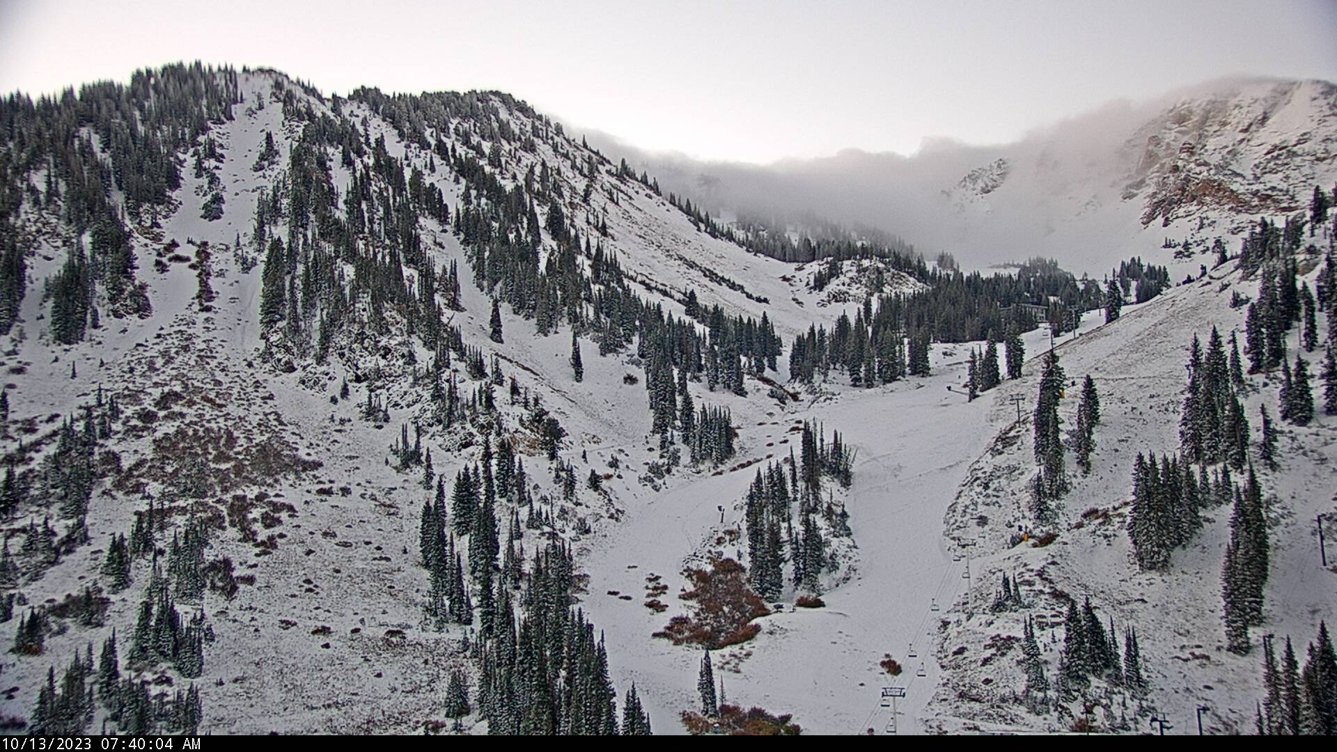
The storm is over.  Automated observations from Alta-Collins indicate a storm total of 15" and a settled snow depth this morning of 12".  The High Rustler cam shows it's white.  If I squint, I think I see some tracks on Nina's.  

By and large though, this puts us solidly in ski purgatory.  Enough snow to whet the appetite, but not really enough to ski.  I'm sure some people will get out, but the current snowpack situation is below my tolerance level and I'm not inclined to risk injury.  Additionally, the forecast looks ridgy.  The NAEFS downscaled ensemble forecast is pretty much a flatline for the next 6-7 days, although there is one plucky member that generates six inches.  


There is always hope.  

I suspect, however, that most of the snow on sunny aspects will melt out over the next several days.  It will survive on upper-elevation shadier aspects, but likely facet and weaken.  Expect heterogeneous avalanche conditions when the next storm comes, whenever that may be.  

Thursday, October 12, 2023

Not Enough Snow for Me

As of 7 AM this morning, the automated Alta-Collins measurements are showing what looks to be 9 inches of new snow (based on 2" through 1600 MDT yesterday and 7" overnight) and a total snow depth of 8 inches.  This from about 1.28" of water.  


Overnight radar imagery (hopefully not mangled by blogger) showed bonafide lake effect for a time overnight that looked strong enough to perhaps produce a bit of lightning and thunder.  


That has now transitioned to more widespread precipitation with a flow direction that is a bit more northerly than I'd like for Alta magic to kick in, as evinced by this morning's 1200 UTC (0600 MDT) sounding.

Source: NOAA/NWS/SPC

I'm inclined to think another 1 to 3 inches today and then you can stick a fork in it.  

I'm sure that will be enough to get some diehards out, but that's not enough snow for me.  I'll continue to recreate on the brown ribbon of flow in the lower to mid elevations.  

Wednesday, October 11, 2023

Thoughts on Great Salt Lake Effect Forecasts from Computer Models

Great Salt Lake Effect forecasts from computer models have historically exhibited poor reliability for a few reasons.  

One is that many computer models have had insufficient resolution (or grid spacing) to adequately resolve the Great Salt Lake and surrounding mountain effects.  

Another is that the Great Salt Lake is simply very sensitive to small changes in the ambient flow and surface conditions, so when you look at a handful of model runs, they don't always capture the full range of possibilities.

Let's take a look at how these issues are manifest in current model runs, starting with the GFS.

The effective grid spacing of the GFS is 13 km.  At it's current level, the Great Salt Lake is about 25-km wide, meaning that in northwesterly flow, the GFS at best has two or three grid points that include lake characteristics.  In addition, the GFS is unable to distingish between the Stansbury, Oquirrh, and Wasatch Ranges, so it cannot separate mountain effects from lake effects.

Below is the GFS forecast for 1200 UTC (6 AM MDT) tomorrow.  The background lake and terrain are not from the GFS.  The lake is from an older, "good old days" lake level and the terrain is fairly realistic.  I use them for reference.  Note that the GFS is capable or producing lake-effect precipitation, but as an enormous blob covering a huge area.  While it is possible we will get lake effect, it's not going to look like this.  

The HRRR, on the other hand, has better resolution.  It has 3-km grid spacing and it better resolves the Great Salt Lake and various mountain ranges of northern Utah.  If we look at the HRRR forecast valid at the same time, we see considerably more structure due to this better resolution.  It produces a lake band that is more concentrated and it also produces orographic precipitation over the central Wasatch.  This is somewhat more realistic.  

That's good, but studies have shown that high resolution models still have problems. Several years ago John McMillen, a graduate student in my group, did retrospective forecasts of 19 lake-effect events using the Weather Research and Forecasting (WRF) model with 1.33 km grid spacing, even finer than the HRRR.  He found that those forecasts were "band happy."  While they produced banded forecasts of banded events, they also produced banded forecasts of non-banded events.  Basically, the model could not reliably distinguish events that were banded from non-banded.  So, when the HRRR generates a band, that's great, but you can't have a lot of confidence that Mother Nature will do the same.  

He also found that the bands were often in the wrong place and most commonly to the right (relative to the downstream flow direction) of the observed band position.  This is something that has also been identified in other model forecasts over other lakes, such as Lake Ontario.  

Another challenge for getting the lake-effect location right is sensitivity to the large scale flow.  The centers of the GFS and HRRR bands in the forecasts above are clearly different, but so are the flow fields.  Small changes in wind direction make a big difference, and current ensemble modeling systems can't paint out the full range of possibilities due either to insufficient resolution or too few members.  

So, many elements are in place for lake-effect tonight.  Many elements are also in place for orographic precipitation.  Either could materialize, but location and intensity are difficult to anticipate at this time.  

I look forward to seeing how this all plays out.

Tuesday, October 10, 2023

A Storm Worth Watching

Enjoy today's mild weather because things are gonna change. I can feel it.  

By tomorrow morning, we will be in colder air.  The GFS shows that by 1200 UTC (6 AM MDT) tomorrow morning the surface cold front is through and we are in colder, westerly flow.  

Temperatures and snow levels will be dropping overnight and in the wake of the cold front.  Our GFS-derived forecast product for upper Little Cottonwood shows forecast highs for Alta-Collins today in the low 50s, fairly close to yesterdays 54°F max, and then temperatures falling overnight and remaining in the low 30s tomorrow.  

Concurrently, the wet-bub zero level drops to below 8000 ft by 9 AM tomorrow morning and near 7000 ft by 6 PM tomorrow afternoon.  That puts the snow level around 7500 feet in the morning and perhaps 6500 ft by afternoon.  

The GFS generates periods of snow with and following the front, adding up to about 8" at Alta-Collins by  6 AM Thursday.  The HRRR produces just under 8" by 6 AM Thursday, so that's decent agreement.  

There are, however, some real wildcards for this one.  The models are generating a prolonged period of cold, unstable post-frontal flow through Thursday afternoon.  The GFS has WNW flow at crest level (700-mb) during that post-frontal period.  

This raises the possibility of orographic and lake-effect snowshowers.  In the case of the latter, our GFS-derived lake-effect guidance is generating decent lake-effect likelihoods late Wednesday night and Thursday morning.  


The GFS large-scale forecast conditions in terms of instability and flow direction looks pretty good for the Cottonwoods.  However, that model can't really resolve the Great Salt Lake or the central Wasatch terrain.  The HRRR, on the other hand, can better resolve the Great Salt Lake and the central Wasatch.  However, it favors more northerly flow.  As a result, it produces a lake band, but more for the Oquirrhs than the hallowed ground of Cottonwoods.


The HRRR also produces a powerful lake band.  That might come through, but models like the HRRR tend to produce strongly banded features more commonly than Mother Nature, who favors more disorganized systems.  

We'll have to see how this one plays out.  I think that 6-12" for Alta-Collins is likely through Thursday afternoon, but we could do better if we can get the right flow and productive orographic and/or lake-effect snow showers late Wednesday night and Thursday.  

I usually conclude posts like this with "keep your fingers crossed," but it is unclear what to root for so early in the year.  I've seen these early season snowfalls turn to freaky facets too many times.  This is a storm that perhaps needs to go big or go home.