Tuesday, June 9, 2020

Little Cottonwood Canyon Transportation Alternatives

The Utah Department of Transportation has identified three alternatives for more in-depth study to improve transportation in Little Cottonwood Canyon.  Information is available at https://littlecottonwoodeis.udot.utah.gov/ and you can also input comments from June 8 – July 10, 2020 via the web site or other avenues described at the site.

The three alternatives are summarized below, including capital and O&M costs.
Source: https://littlecottonwoodeis.udot.utah.gov/wp-content/uploads/2020/05/9234_42_LCC_EIS_Alternatives_Project_Factsheet_FIN_WEB.pdf
I thought I would talk a little about the gondola option based on my experience in Austria last year.  We have also discussed this in a previous post in December 2019.

Stubai Glacier ski resort in the upper Stubai Valley south of Innsbruck has a tri-cable gondola similar to the one proposed in the third alternative above.  The gondola, labeled 3S Eisgrat I and II below and referred to as the Eisgratbahn, is the primary lift for accessing most of the ski terrain.  There is an old 4-person gondola, labeled Gamsgarten I and II that can also be used, but it has a limited capacity.


Stubai Glacier has an uphill lift capacity of 40,000 skiers.  For comparison, Alta and Snowbird combined have an uphill capacity of about 30,000 skiers.  At Stubai Glacier, it is sometimes possible to ski to the base, but more often than not, due either to lack of snow or avalanche hazard, the Eisgratbahn is the primary way for skiers to access and exit the ski area.

The Eisgratbahn has an uphill capacity of 3,000 skiers per hour with large capacity gondola cars traveling at about 17 miles per hour.  The video below provides some context.


Curiously, the alternatives summary above appears to undersell the transport capabilities of a tri-cable gondola by listing the number of people per peak hour via transit as 1,050. The text below suggests that for some reason, UDOT assumed a similar peak-hour ridership of about 1,000 people per hour.  The capacity of the gondola would be much higher than that, although this assumes you can get people to the base of the canyon at that rate (as well as extract them from the base of the canyon at the end of the day).


I have a number of questions about how this will be paid for, how much it will cost to ride, how gondola costs or tolling might affect public access to the canyon in summer as well as winter, etc.  Beyond that, here are some additional thoughts:

  • The White Pine Trailhead is critical for accessing the Lone Peak Wilderness area and parking there is extremely limited.  The current design has an angle station near Tanners Flat Campground.  Is there a plan to modify access to the Red and White Pine trails from that location? 
  • What is planned for ADA-accessible trails between stations?  If we are to build something of this magnitude, people with a wide range of abilities should be able to hike point-to-point along the gondola line.  
  • How does the mountain accord fit into this?  That effort to create a coherent plan for the central Wasatch appears to have languished and the web site, mountainaccord.com, isn't even functioning, at least this morning.  Building this gondola must be a component of a larger vision for the Wasatch Range.
  • This may be addressed in the EIS if I give it a deeper dive, but are we still dealing with a bottleneck at the bottom of the canyons?  A dedicated bus lane along Wasatch Boulevard is a positive step forward, but the combined traffic of Big and Little Cottonwood Canyons backs up beyond the proposed mobility hub and there are other bottlenecks as well.  A large capacity gondola is great, but only if people can get to it.
  • What about Big Cottonwood Canyon?  Although focus on Little Cottonwood may reflect political realities, it's disappointing not to see a canyon-wide plan.  Traffic issues to and within both canyons are intrinsically linked.
  • If built, the gondola will be used for decades, which means it will be operating in the summer in a warmer climate than today.  Gondola cars will need to be designed to deal with with ridership on hot summer days warmer than those we see today.  
I'm interested in your thoughts.  Feel free to add to the discussion in the comments below.

Sunday, June 7, 2020

Are Universities Being Realistic about Reopening?

As a professor and the parent two college students, I'm deeply concerned about university plans to "reopen" in the fall.

Reopening plans for the University of Utah, where I am a professor and my son attends, are available at https://returntocampus.utah.edu/.  This web page is not very specific, but states that classes will resume "in a mixture of in-person and hybrid delivery," that fall break will be cancelled, and that instruction will shift to all online after the Thanksgiving break.  Physical distancing "protocols" will be in place.  All individuals "are expected" to follow state and local guidelines for wearing face coverings.

Not discussed at all but hopefully forthcoming soon, are testing protocols, how the university will define and deal with outbreaks, whether or not mask wearing will be mandatory, options for high-risk students, etc.

My daughter attends Arizona State and their reopen information is a bit more detailed and available at https://www.asu.edu/about/fall-2020.  They use branding to discuss what they are planning (e.g., ASU immersion, ASU sync, iCourses), but essentially the strategy is similar, although they are more explicit that some courses will be entirely online.  They are also more explicit about plans to use synchronous learning in which some students attend online while others attend in person.  They state that employees and students will be required to wear a face cover while in ASU buildings and in outdoor community areas where distancing is not possible.  They provide considerable information on testing availability and they like.

My view is that ASU is ahead of the U right now in terms of providing more detailed (but still not detailed enough) information to students and parents, but know the U is working to provide more detials.  However, I am still concerned about reopening at both schools and other institutions.

The coronavirus is a highly infectious disease often spread by asymptomatic individuals in indoor areas.  Per capita case rates in the United States are remarkably high and even in Utah they are higher than many other countries.  On June 1st, Utah reached 9,999 cases (call it 10,000), which is 3,125 per million people.  I've put that on a chart below (red dot) relative to cases per million people from several other countries to illustrate where we were on June 1.


Since then, cases have spiked, so instead of flattening the curve, ours is bending up again.

Given the prevalence of coronavirus in the community, the mobility and social interconnectivity of students, and the reality of in-person instruction and other learning activities, are universities being realistic about the potential for spread or outbreak and the effectiveness of hybrid teaching?

According to the Office of Budget and Institutional Analysis, during the 2019/20 school year, 24,485 undergraduate and 8,333 graduate students attended the University of Utah.  The U also had 2,167 full- and part-time faculty members.  I could not find a count on their site for staff, but suspect it would be several thousand (perhaps more) if we include administrative and research staff.  Basically, the University of Utah is a small city of more than 40,000 people, not counting the hospitals and medical facilities.

A large fraction of these people travel to and from campus from all over the metro area.  This often involves taking mass transit, which is often quite full during the morning commute.  People need to eat and get around between classes.  There are many choke points on campus.  Students are going to socialize.  Thus, the potential for coronavirus spread or outbreak extends beyond the classroom and even campus. 

Hybrid instruction is being sold as a option of providing an in-person experience with social distancing, but what this will involve at the University of Utah is unclear.  How often will students attend class?  Will the instructor need to teach simultaneously in-person and online?  Will there be online lectures with a portion of the class attending shorter, in-person classes?  Will faculty have the freedom to design an approach that works best for their topics and activities?  Is this really better than online?

Instruction varies tremendously at universities with a wide range of teaching topics, activities, and environments.  Some classes are nearly (or maybe completely) impossible to teach effectively online, others can be taught nearly as effectively online as they can in-person with the tremendous restrictions imposed by the coronavirus.  Thus, as a faculty member I'm interested in having some ability to decide what is best for my classes.   As a parent, I'm most concerned about my children receiving a good educational experience.  I support classes that can be taught effectively online taking advantage of that format in the hopes that other classes that my children take that really require in-person instruction have the best chance of being offered through the semester without a lot of abrupt cancelations or transitions to all online due to outbreaks.

Finally, there is the reality that the coronavirus will be on campus.  Outbreaks may necessitate switching to full online instruction with little notice.  Faculty, staff, and students are going to need to miss an above-average number of classes due to coronavirus or illnesses with corona-virus-like symptoms.  In some instances, the symptoms could be severe or worse.  Care for students who may quarantined far from home is a concern that I have as a parent.  There are other scenarios that I would rather not think about. 

Ultimately, I would like to see the following:

1. Strong encouragement of faculty and staff to continue to telework as much as is possible to reduce density on campus and transit (I believe this would occur if the U is at "yellow" or higher risk levels).

2. Strong encouragement of students to reduce their presence on campus as much as possible, taking advantage of tele options to meet with faculty, advisors, etc.

3. Providing faculty with the option to design their course (online or various hybrid options) in a way that they think will be most effective while still meeting University distancing and other criteria. 

4. Encouraging faculty faculty to move classes online if they can do so effectively.

5. Mandatory mask use in classrooms and public spaces.

6. Transparency in all decision making, which considers diverse perspectives. 

I confess pessimism about the plans currently being put forth by Utah, Arizona State and other universities, although I hope that ultimately that pessimism is unjustified. 

Storms in Spades

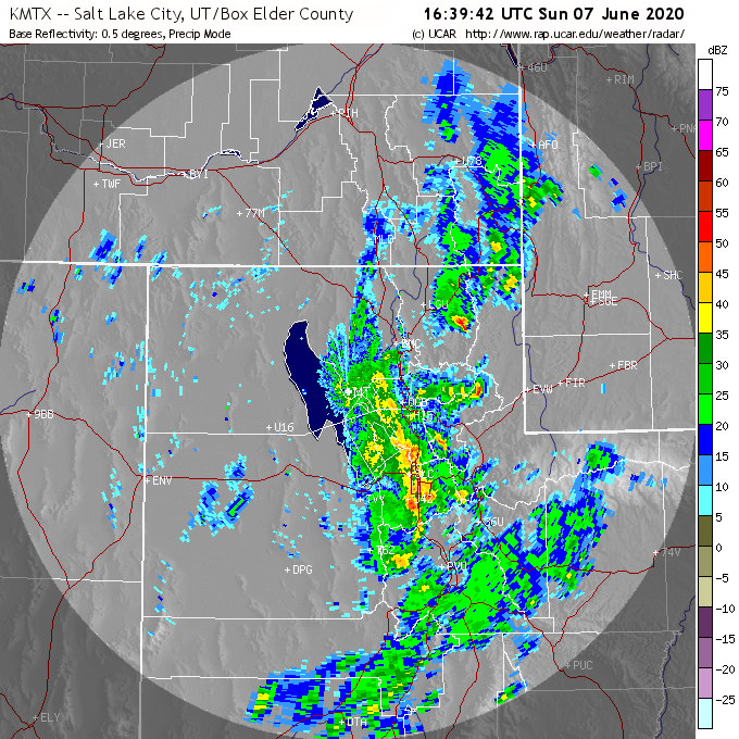
Active weather with lightning, thunder, strong winds, and hail continues today.  Below are a couple of radar images from this morning showing strong storms in the Wasatch Front area.


We had a round of strong winds here in the upper Aves this morning and also some small hail that was a bit larger than pea sized.


So far, the big winner in the hail category appears to be Plain City.  A viewer tweeted this photo to Chase Thomason of KUTV2 news. 


Keep an eye on the sky as the thunderstorm threat continues today.

Saturday, June 6, 2020

Quite a Saturday Ahead

Mother Nature will be throwing an active day at us today and she is already bringing the goods.

I was up early this morning as I have quite a bit of yardwork to do today, but the weather is not cooperating.  Showers and thunderstorms extend from the Oquirrhs into eastern Utah at 1300 UTC (0700 MDT). 


These storms have been moving northward, leaving a trial of lightning strikes from I-70 to just north of Evanston.  The highest lightning-strike densities are well east of I-15, but there have also been a few in the Salt Lake Valley and adjoining Wasatch Mountains. 

Source: LightningMaps.org.  Lightning in hour ending at 0709 MDT.
Today will be the epitome of if you don't like the weather, wait 5 minutes.  The latest HRRR shows periods of showers and thunderstorms in the southerly flow ahead of the front (which we are currently in) and with the approach and passage of the front around 1800 MDT.  I've selected a few forecast hours below to illustrate both the active and break periods over the Salt Lake Valley.  Keep in mind that the chaotic nature of thunderstorms means that you can't count on precision in these forecasts and should keep an eye to the sky throughout the day.  


In addition to rain, we've had some strong winds in the area.  My house has done quite a bit of shaking at times.  Weather observations from a citizen observer in the upper aves show a peak gust of 68 mph yesterday at about 1900 MDT and then a gust this morning of 54 mph at about 0700 MDT.  

Source: MesoWest
Since yesterday, peak gusts reported to MesoWest include 78 mph on the Salt Flats, 70 mph at the Moab Airport, 68 mph in the upper Aves, 64 mph in Magna, 62 mph in Parley's Canyon, 61 mph near Point of the Mountain, and 52 mph at the Salt Lake City Airport.  The list of stations reporting gusts over 50 mph is remarkably long, so strong gusts were reported in many areas.

Stay safe out there.  When thunder roars, head indoors.

Friday, June 5, 2020

Good Storm Chasing Weather?

Being a severe-weather aficionado in Utah is a bit like being a powder skier in Oklahoma.  The pickings are slim. 

However, unlike powder skiing in Oklahoma, which is essentially non-existent, there are a few days a year where something exciting might happen around here. 

The Storm Prediction Center puts parts of Utah in the marginal severe thunderstorm risk category over the next two forecast periods. 


A severe thunderstorm is one with wind gusts of 58 mph, hail at least an inch in diameter, and/or a tornado.  Marginal risk means that the storms could be spotty and limited in duration and/or intensity.  However, this is Utah and marginal is about the highest you see.

The SPC convective outlook discussion highlights that increasing moisture, strengthening wind shear, and other environmental characteristics should be favorable for isolated strong storms, potentially with strong winds and hail.  The NWS Forecast office in Salt Lake City has also issued a flash-flood watch for portions of central and eastern Utah. 


While I mentioned the storm chasing potential, the reality is that severe weather is hazardous weather.  Be careful out there and monitor forecasts, watches, and warnings.

Thursday, June 4, 2020

Big Changes Are Coming

Major changes are on tap weatherwise over the next several days.

Today looks to be hot and tomorrow (Friday) even hotter as a closed low off the coast of Baja California begins to fill and lift into the southwest United States.  This leads to strong southerly flow across the Great Basin with temperature climbing and fire weather conditions deteriorating. 


NWS forecast highs for the Salt Lake City Airport are 91˚F today and 96˚F tomorrow.  Disgusting.

Saturday's forecast is crapshootish as the former closed low continues to fill and moves across Utah and a much deeper trough approaches from the west.  Right now, the GFS has the former moving across Utah in the morning and producing showers and thunderstorms producing the heaviest precipitation over central and eastern Utah.


The situation for northern Utah is pretty complicated due to the weak atmospheric stability, a front approaching from the west, and a moisture dryslot.  My guess is that there will be some decent weather on Saturday, but the threat of some showers and thunderstorms is real, so keep an eye on the radar, another on the sky, and adjust as needed. 

Right now, the GFS has the frontal band approaching Salt Lake City late Saturday and over Salt Lake City by 0300 UTC 7 June (9 PM MDT Saturday). 


That will be followed by cooler weather with periods of showers and possible some thunder as the pattern will be markedly springlike.  The NWS forecast high for Monday is 59˚F, nearly 40˚F lower than their forecast for Friday. 

If you are recreating this weekend, be aware that changes are coming and consult NWS forecasts.  Expect some evolution in forecast details (e.g., the timing of the front or periods of thunderstorms or showers), but the threats for critical fire weather conditions Friday and thunderstorms and heavy rain that could produce flash floods in southern and eastern Utah are real, as well as the overall cooling trend.  NWS flashflood information available at https://www.weather.gov/slc/flashflood.