Saturday, February 4, 2012

Easterlies, Part II

Also related to the large-scale pattern and easterly flow discussed in the previous post is a major snowstorm that has pummeled Denver and the adjoining Rocky Mountain foothills over the past two days.  The snow accumulations provided by the CoCoRaHS network are impressive.


Source: CoCoRaHS
A curious aspect of many (but not all) of the major snowstorms that strike the Boulder/Denver area is that they are often confined to the plains and adjoining "foothills" of the Front Range.  Although the maps above do not include terrain, note how the heaviest snowfall (dark green and orange colors) is in Laramie, Boulder, Glipin, and Clear Creek counties, as well as environs to the east.  These areas are east of the Continental Divide, whereas the major ski areas are west of the Continental Divide and received far less snow.  Loveland Pass, which is located on the Continental Divide, reports only 4" of snow in the past 48 hours.

Thus, those looking for deep snow need to be thinking backcountry turns in the Front Range foothills or hitting one of the smaller, lesser known ski areas like Eldora or Echo Mountain.  Eldora reports 31" in the past 48 hours, whereas Echo Mountain reports 55".

I'd never even heard of Echo Mountain until I saw it pop up on the snow report.  It is a very small mountain with only 660 feet of vertical.  I suspect that most of the terrain is not steep enough to enable one to make turns in snow this deep.  Even if it is, it's closed this morning for a "snowdash event!"


Ah, the joys of skiing Colorado...

Easterlies

Blowing snow yesterday in easterly flow on the Pfeifferhorn.
Photo: Jeff Massey
We're presently in the midst of a prolonged period of easterly flow along the Wasatch Front, with some interesting variations in the areas receiving the strong winds.

Yesterday was a beautiful day in the Wasatch Mountains, although it was strange seeing flow from the east.  This year seems like we've woken up in some sort of Bizarro world where everything is the opposite of what it should be.


The cause of all this Bizarroness is the trough that came through Wednesday and Thursday and has closed off over the interior western United States.  Yesterday the trough at 500 mb was centered over northwest Colorado with 35 knot easterly flow at 700 mb (roughly crest level) over northern Utah.


The trough deformed somewhat overnight, but the 500-mb axis still extends back over Utah and Nevada.  The 700 mb flow is  not as strong, but a strong pressure gradient is draped across the northern Wasatch with high pressure over southwest Wyoming.


Strong easterly flow has been observed at the University of Utah since about 1600 UTC yesterday.  There are two periods of peak winds, one shortly after the onset of easterlies ~1600 UTC yesterday, and the other this morning at ~1200 UTC.


In contrast, further to the north near Centerville, a site along the Union Pacific rail corridor observed the strongest easterlies earlier, from 0700-1700 UTC yesterday, with out as strong of a secondary maximum this morning.


This is a good case to examine in greater detail to better understand contrasts in the strength and timing of strong easterly flow near the University of Utah and the Centerville area.  For you atmospheric sciences undergrads, this could make a good senior thesis project.

Friday, February 3, 2012

Perspectives on a "Bad" Ski Season in Utah

Source: http://www.motifake.com/38646. 
Most people know that I am a powder snob and enjoy poking fun at Colorado.  There may be good reasons to ski there, but deep powder is not one of them (except in sections of the San Juans).

Of course, everyone in Utah loves to thumb their noses at Colorado.  I have a friend who was exiled to Boulder for a while.  While there, when people asked him where he headed to ski, he told them east.  They would look at him incredulously and then he would respond, "to the airport, to catch a plane to Salt Lake."

Why? Perhaps we should put the "bad" Utah ski season thus far into perspective.  According to alta.com, Alta has received 167" of snow through January.  Pathetic by Utah standards, but how does that compare to Colorado?  One of the snowier locations with long-term weather records in the heart of Colorado ski country is Berthoud Pass, which averages about 390" a year.  That is more than the advertised average snowfall at all Colorado resorts except for Silverton, Loveland, and Wolf Creek (at least according to rockies.com).  Indeed, Wolf Creek is pretty snowy with an average of 435", but the bulk of ski days in Colorado are elsewhere.

Therefore, we'll concentrate on Berthoud Pass.  In an average year, Berthoud Pass receives 187" of snow through January, just 20" more than Alta has received.  In other words, this year Alta is just a bit behind an average year at one of the snowier locations in Colorado (with due apologies to Wolf Creek Pass).

So, a bad year at Alta (and the upper Cottonwood Canyons in general) is as good as an average year in Colorado, at least when it comes to snowfall.  How about deep powder days?  Let's use 10" as a lower threshold for a deep powder day.  Alta averages 17.4 days with 10" or more, Berthoud Pass 3.8.  Of course this year, Alta has seen few deep powder days, but that gives you an idea of what an average year is in Colorado.

Of course, if Colorado wishes to retaliate, they only need to pull up the climate statistics for near the base of Park City.

Thursday, February 2, 2012

Romanian Dumpage

With another disappointing storm behind us (3" at Alta) and at least 7–10 days of mainly dry weather ahead of us, it is time to start looking elsewhere for our powder fix.

How about Bucharest, Romania?  Eastern Europe is in the grips of a cold wave and Bucharest got pounded with snow last week.  I was blown away by the photo below, which was taken last Friday and posted on cnn.com.

Source: cnn.com/AFP/Getty Images
Bucharest lies in eastern Romania between the Carpathian Mountains, which form a hook in central Romania, and the Black Sea.

Source: Google Maps
The Carpatians are 1200–2000 m high, with some higher peaks in the area northwest of Bucharest.  Not a huge range, but, like the Appalachians, sufficiently high to block cold air at low levels under the right conditions.

This appears to have happened late last week.  As shown in the 0000 UTC 28 Jan GFS analysis below,  cold air from the Ukraine and interior Eurasia channeled southward and then westward around the Carpathians.

1000 mb wind and temperature at 0000 UTC 28 Jan 2012.
Color scale changes every 2ÂșC (sorry about the lack of a scale).
Click to enlarge
This appears to be quite similar to the cold-air damming that occurs east of the Appalachians.  In addition, a pronounced coastal front developed along the west coast of the Black Sea and likely served as a locus for heavy precipitation (note the temperature contrast).  Similar coastal fronts often form along the northeast and mid-atlantic coast of the United States in response to cold-air damming and contrasts in surface sensible heat fluxes between the land and ocean.

Further digging is needed to determine the role of these orographic and coastal processes on the Bucharest storm, but it sure looks like an interesting case.

Kill Punxsutawney Phil

Unleash Carl Spackler on Punxsutawney Phil
So, the groundhog predicted 6 more weeks of winter.  So what?  Bring an end to this pseudoscientific drivel and the "torture" of animals by weird old men in top hats and tails!

Wednesday, February 1, 2012

Forecast Challenges for Tonight

Although our computer models continue to improve, a reality of weather prediction is that operational forecast models run by the National Weather Service are of varying resolution and in some instances do a poor job resolving the terrain of northern Utah.  As a result, it is up to the meteorologist to infer how the topography will affect storm systems as they move through the state.  This can be done quantitatively using statistical techniques (sometimes referred to as downscaling) and/or qualitatively based on experience and intuition.

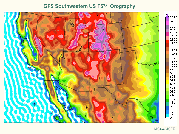
For example, the Global Forecast System (GFS) has an effective grid spacing of about 25 km.  At this grid spacing, it is unable to resolve the narrow Wasatch Mountains, as well as other upstream ranges in the Great Basin.
Source: UCAR Comet
Instead, there is only one major mountain barrier to the west of the Salt Lake Valley, which rises continuously to the Uinta Mountains.  We jokingly call this mountain barrier the "Uinta-satch" mountains.

Despite its lower resolution (compared to models like the NAM which is available at 12 and 4 km grid spacing), the GFS has consistently produced better forecasts this winter in terms of the track and timing of storms over the western United States.  The challenged posed by this, however, is how to adjust the GFS for terrain effects and how much to trust the precipitation produced by the NAM when its forecast differs from the GFS.

A case in point is the forecast for tonight.  Both models bring a trough through northern Utah, but differ on the details of the precipitation forecast.  For the period ending at 1200 UTC (0500 MST) tomorrow, the GFS puts a band well downstream of Salt Lake roughly over it's "Uinta-satch" mountains.


In contrast, the NAM puts a band of precipitation that extends more over the southeastern Great Salt Lake and Salt Lake Valley, with a precipitation maximum near the UT-WY-CO triple point (note that in these plots, the GFS precipitation is a 6-h accumulation, whereas the NAM a 3-h accumulation).


For Alta, the NAM generates .31" of snow water equivalent through noon tomorrow (Thursday), whereas the GFS only generates .10".  If we convert that water to snow using the Alcott algorithm, the NAM yields 4.7" of snow compared to only 1.4" in the GFS.

Precipitation contrasts between the NAM and the GFS are related differences in model topography, but given the deep closed low moving over the area, are probably also related to differences in the strength and timing of precipitation features (including possible lake enhancement in the NAM, which develops shortly after the time presented above). A meteorologist can perhaps make adjustments for the former, but the latter are difficult to predict with precision.

So, I see this as a difficult forecast.  Given the characteristics of the storm, I lean toward something like 4–8" at Alta through noon tomorrow.  That being said, I won't be surprised if accumulations are outside this window on either the high or low side.  This is an instance where small-scale details that cannot be confidently predicted can make or break a storm.