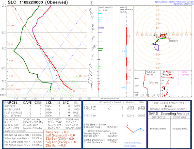
Yesterday provided a few examples of mixing (or lack thereof) in a stable atmosphere. First, let's have a look at the morning sounding from Salt Lake City, which showed a shallow surface-based inversion below 850 mb, surmounted by a stable layer that extended to about 775 mb, or 1 km above the valley floor. In both of these layers, one would expect limited vertical transport and mixing.
Indeed that morning there was copious evidence of this limited vertical transport and mixing. First, there was a structural fire at about 9:30 am near Cottonwood Heights that produced a fascinating smoke plume with a zig-zagged or perhaps spiraled layered pattern (click to enlarge).
 |
| Photo: Sebastian Hoch |
The layering of the smoke provides visual evidence confirming the atmospheric stability in the lower km of the atmosphere. Meteorologists call such flows with limited mixing between the layers, laminar. The real mystery here, however, is explaining the zig-zagging of the smoke, which I interpret as the result of either a reversal of the cross-valley wind component with height or an oscillation in wind direction over time, but can't really confirm or deny either of these hypotheses with the observations available.
Second, was the hideous brown cloud over the Great Salt Lake and northern Salt Lake Valley.
This is a common sight when looking west from the University of Utah following a clear night. I've long thought this was a reflection of the advection of all our urban pollutants out over the lake by the nocturnal southeasterly drainage flow over the Salt Lake Valley, although optical effects may contribute to its apparent positioning as well. Typically one can see the layer deepen and spread into the valley during the day as the surface heats, mixing ensues, and the up-valley flow and lake-breeze produce north-northwest flow.
Fortunately for us, we still get enough heating from the sun to develop a decent convective boundary layer during the day. Yesterday, the boundary layer reached to about 725 mb, which means we're not seeing a buildup of high pollutant concentrations.
This same scenario in January, with snow on the ground, would certainly produce hazardous air quality.


But when are we going to get real weather, like rain and snow?
ReplyDeleteIf you want real rain and snow, it looks like getting on a plane will be your best bet for quite a while. Maybe we'll get a quick hit from a brush-by system, but for the most part, it looks dry for the next week and maybe beyond.
ReplyDeleteI have been watching the long-range models and some have been hinting for a while that Hurricane Hilary (currently developing off coast of Mexico) may have an impact on our weather around the first couple days of October. Still a ways out, but worth keeping an eye on. Would give it at least a 1 in 3 chance, in terms of getting some significant moisture from it.
ReplyDelete