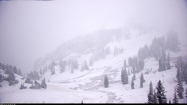
Tuesday, October 29, 2024

Scary Things for Halloween


It's been a while since we did a list on this blog, so let's create a list of 10 scary things for Halloween:

  • Not only is this season a crappy one for snow, but we have several more in the rest of the 2020s, resulting in further decline of the Great Salt Lake.
  • I wake up one day and all of the code used to create products for weather.utah.edu is gone.  Or worse yet, I just accidentally delete it.  Even with backups, it would take a huge amount of time to get everything running again.
  • I abandon the Wasatch Weather Weenies due to the demands of new "workload policies" being implemented at the University of Utah  
  • The 10% budget cuts being floated by legislative leaders for the University of Utah come to fruition and instead of cutting administration, most of the pain is passed down to instructional units that are already stressed by recent enrollment increases. 
  • The legislature passes a revised version of last year's Senate Bill 226, the so-called School of General Education Act, establishing a new School of General Education at the University of Utah with all students required to take mandated courses taught by new faculty who are commited to "traditional" general education.   
  • UDOT accelerates plans for the Little Cottonwood Canyon gondola. To pay for it, they propose a sales tax for Salt Lake City and Park City.  The cost for a round-trip ride will be $75, but for $60 you can get a one-way ticket and then ski down a new trail that they will construct along Little Cottonwood Creek. 
  • The Wasatch Front continues to add 45,000 residents a year and every one of them is a digital nomad that skis 50+ days a year.  
  • Powder Mountain goes fully private with a gated entry at the bottom of SR-158. 
  • Deer Valley expands into the Mayflower area only to discover that it hardly snows there.  Oh wait, this one is already scary.
  • Alta announces plans to build a high-speed six pack directly from the Wildcat base to the top of High Boy.  To deal with the added volumes of skiers, upper High Boy and Stonecrusher will be covered by extensive snowmaking.  Whippet poles will be required unless you ski Greeley Bowl.
  • The current storm is a bust and produces only 2" at Alta.
Wait, that's 11.  Happy Halloween.  

Sunday, October 27, 2024

The Storm Ahead

Change is on the way as a deep upper-level trough is expected to move into the western United States early this week.  The GFS forecast for 0000 UTC 29 October (6 PM MDT Monday) puts the surface front over northern Utah and the Salt Lake Valley in cooler, northwesterly, post-frontal flow.  

This storm reminds me a good deal of the last with the trough digging into California and the bulk of the "dynamics", or large-scale lift ahead of the trough, moving across southern Utah and Colorado.  However, there is potentially one important difference.  Instead of closing off over central Utah, the trough remains what we call an "open wave" which means the GFS ultimately puts us into a colder, moister, northwesterly flow on Tuesday, as illustrated below.  


Our GFS-derived forecast for Little Cottonwood Canyon ultimately generates just over an inch of water and 16 inches of snow through 6 AM MDT Wednesday.  This is a colder storm than the previous one two, with temperatures forecast to drop to 10°F at the top of Mt. Baldy and snow to liquid ratios ultimately incresing to about 20:1 at the end of the storm.  


All in all, the GFS is producing a pretty good right-side-up Goldilocks storm.  If only we had a base for it to fall on.  

That said, the GFS is a bit more excited than most members of the Utah Snow Ensemble.  Both the GEFS and ENS mean through 6 AM MDT Wednesday (12Z 30 Oct) are right around 0.7" of water and 10" of snow.  If you like to wishcast, there are 3 members (out of 82) that produce more than 1.5" of water and 20" of snow.  

We've been working internally to produce snow forecasts using the experimental Rapid Refresh Forecast System (RRFS) that is being developed by the National Weather Service.  It only has 6 members and only goes out to 00Z 30 Oct (6 PM MDT Tuesday), so it doesn't capture the entire storm period, but through that time, the members are putting out 4-12" of snow.  For comparison, the GFS is putting out 15". 


So, to summarize, most of the model guidance at the moment is giving us a modest storm, with the GFS and a relatively small percentage of ensemble members going for amounts above 15".  There really are two wildcards with this storm.  One is will the frontal precipitation with the system, which is advertise to be sort of disorganized over northern Utah, come together for a while over the central Wasatch.  The second is will we get a decent shot of northwesterly flow post-frontal magic.  I'm inclined to be thinking 8-14" for a storm total through Wednesday morning, but we will see how things come together over the next couple of days. 

Thursday, October 24, 2024

Transition to a More Active Pattern?

Fall this year has been pretty quiet and warm.  September at the Salt Lake City Airport brought only 0.42" of precipitation compared to a normal of 1.06".  October only 0.61" so far, compared to a normal of 0.96" for the month to date.  

Average temperatures for September 1 - October 22 have also been remarkably high.  In fact, they are the highest on record, with a mean of 70.2°F, just ahead of the same period in 2022 (70.1°F). 

We had a mainly dry frontal passage in the Salt Lake Valley last night, so it will be cooler today before ridging returns, but the models are now advertising some major changes next week including a deep trough forecast by the GFS to be over the western US at 1200 UTC 29 October (6 AM Tuesday).  

Snowfall produced by this system will depend a lot on track as this one has some potential to "go south" literally and figuratively.  In the GFS forecast above, much of the flow and dynamics is going into southwest Colorado, for example.  As a result, the GFS forecast, while dropping temperatures substantially in upper Little Cottonwood early next week, is only generating 0.38" of water and 5.5" of snow through 12 PM MDT Thursday, better known as Halloween. This includes a bit from the trough on Tuesday and then another one that drops in on Wednesday.


A look at the Utah Snow Ensemble shows that the means of the downscaled GEFFS and ENS ensembles are about 0.6 and 0.7" water and 8" and 10" of snow, respectively, through 1200 UTC 31 October (0600 MDT Thursday).  The range though is quite large, from nothing to 22" for snow, reflecting uncertainty in the trough characteristics as it swings through the western US.  A few members generate some snow later in the forecast period in early November, although there are others that stay dry.  


My take is that we are starting to see the transition to a more active pattern as the jet stream strengthes with the approach of winter, although storm systems can come in fits and starts this time of year at Utah's latitude.  That said, right now the ensembles are not giving good odds for a big enough dump to ensure ski touring in grassy areas and meadows by the end of October.  Things will either need to come in above the snowier members or you will need to have extremely low standards for skiing quality and personal safety.  Concentrate on the hoping for the former and reevaluating the latter.  

Saturday, October 19, 2024

Living and Learning

Our first storm of the year is in the books.  Alta-Collins came in with about 1.46" of water and, per resort reports this morning, 8" of snow. Snow depth on the ground at Alta-Collins sits at 6", although that is a point measurement and I suspect there is a good deal of variability.  Due to the warm nature of the first part of the storm, snow cover at the base is lower and perhaps an inch or two based on web cams.  

I like to look back at our model-derived forecasts so we can identify capabilities and limitations for future improvements.  Let's first look at the forecast I used for my post these used from my two posts covering the storm.  From Wednesday (A Storm System with Lots of Moving Parts), the 06 UTC GFS forecast was going for a storm total of about 1.3" of water and just over 12" of snow.  I've reproduced that forecast below.  


And below is the 00 UTC Utah Snow Ensemble forecast showing a range for water equivalent of about 0.75" to 3" with means around 1.5" and 1.75" for the ENS and GEFS, respectively, and for snow a range of 6 to just over 30" with means of about 15" and 18", respectively.  Note that I am ignoring the precipitation produce by some ensemble members next week which is well after this storm period.  


So, the GFS water equivalent was just a bit below and, while we can't verify the ensemble spread and probabilities with one storm, the ensemble means were just a bit higher than observed. 

The real trouble in these forecast was the conversion of water equivalent to snow amount.  The forecasts of snow-to-liquid ratio in this instance were simply too high.  This is something that we have seen previously in warm storms in the eastern US, especially those beginning with no preexisting snow cover and warm, unfrozen ground.  This leads to melting and densification of snow on the ground, which we have not explicitly accounted for. 

Such situations don't occur much at Alta-Collins except in the early season, we we actually noticed this looking at storms in the eastern United States.  Behind the scenes we have been developing a system to forecast snow-to-liquid ratio across the continental US and testing it in the experimental Rapid Refresh Forecast System (RRFS) Ensemble.  Below is a forecast for the storm that affected northern New York and New England last week.  I'll focus on northern New York where snow amounts are annotated for Whiteface Mountain.  This forecast called for 14.6", and the NWS Burlington forecast office that forecasts for northern New York reported that the received 15". That sounds like a great forecast, but that 15" is for the summit (4800+ feet) and our RRFS-derived forecast is for about 2500 feet where accumulations were lower.  In addition, a look at the forecast below shows widespread accumulating snow, whereas weather cams showed primarily snowfalling but no accumulations on the ground.   


So, we are living, learning, and taking our medicine during these warm storms.  Often, snow accumulations during such storms can vary depending on the surface and this is something we have also been thinking about, such as providing two or three different accumulation forecasts depending on whether or not the surface is grass, pavement, etc.  

Concerning this most recent Utah storm, perhaps we did a bit better at upper elevations?  If you are insane enough to venture high, let me know.  Note that I do not encourage skiing.  Not only are these scant amounts, but the flow direction was probably not optimal for wind transport into the main chute.  Someone probably skied it anyway.  

Thursday, October 17, 2024

Storm Update

The surface cold front passed the airport last night at a bit before 1 AM MDT as denoted by a 5F or so drop in temperature and a veering of the winds from southerly to WNW.  Look carefully in the top plot below for the abrupt drop in temperature and rise in dewpoint and humidity.  

Source: mesowest.utah.edu

And so the endless summer of 2024 came to an end.  Although we could be flirting with the upper 70s again next week, we'll call that fall or autumn, whichever you prefer.  

Showers and then widespread precipitation then moved into northern Utah with the precipitation in the early morning hours being more widespread than I anticipated yesterday.  That's a good thing as we have had little to no precipitation for over 3 weeks and this is beneficial precipitation to saturate soils and settle down the Yellow Lake Fire. 

As of 7 am, the snow line is sitting somewhere around 9600 feet.  Alta web cams show the white stuff covering the ground above 10000 ft. 


Source: https://www.alta.com/weather

But the High Rustler Cam shows the snow line just a bit off the top of the run, which is at 9800 feet.  

Source: https://www.alta.com/weather

And one can see a trace of snow on the snow stake at just over 9600 feet.

Source: https://www.alta.com/weather

I put snow line in italics above as I consider that the level at which snow is sticking and accumulating on the ground.  This is different than snow level, which is the level down to which snow is falling.  This time of year, they can be different given the warm ground.    

Radar and the models suggest we'll see precipitation for a bit more this morning, then more scattered showers with a possible break before the main trough moves in later today and tonight.  A look at the HRRR forecast for the wet-bulb zero level shows it falling gradually to about 8500 feet by 6 PM this afternoon and then dropping abruptly to 5500 feet from about 10 AM to 2 AM as the main trough approaches. Thus, we will probably see snow levels dropping to 8000 feet today before it drops to near bench level tonight.  


Much could happen tonight as the main trough approaches Utah.  Through 7 AM this morning, the HRRR had produced about 1.5" for Alta-Collins.  This is a bit ahead of reality (which is closer to 0.3") for that elevation, but might not be too bad at 10,000 feet.  It then adds another 9" or so through tomorrow night. Given the crap shoot nature of what is going to happen as the upper-level trough approaches and closes off to our south, I'm going to stick with my 8-16" forecast from yesterday for Alta-Collins.  

Wednesday, October 16, 2024

A Storm System with Lots of Moving Parts

Enjoy the last day of summer today.  Big changes are coming in the form of a storm system with a lot of moving parts.  

Let's have a look at some of the details as predicted by the GFS and HRRR.  For this 2100 UTC 16 Oct (3 PM MDT this afternoon), the GFS calls for dry southwesterly flow at 700-mb (lower left) and by extension, the surface.  I don't expect strong winds today, so let's just call it breezy.  


For the same time, the more detailed HRRR is producing some scattered showers over central Utah and the western Uintas.  This could produce some strong gusty winds for the Yellow Lake Fire. I am hoping for the best there during this windier pre-frontal period. 


Summer ends sometime tonight with the arrival of the surface cold front.  The latest HRRR has the cold front entering the northern Salt Lake Valley around 0500 UTC 17 Oct (11 PM MDT this evening).  Unlike some cold fronts which have an intense line of precipitation, this one looks to come in mainly dry initially with just some scattered showers. 

The GFS forecast valid 0600 UTC 17 Oct shows that this front and it's accompanying upper level trough are relatively weak and it is really the stronger trough over the Pacific Northwest that is going to bring the bulk of the precipitation to northern Utah.  


Indeed, by 0000 UTC 18 Oct (6 PM MDT Thursday), that trough has dug into Nevada with widespread precipitation over northern Nevada and northern Utah. 

All of this suggests some periods of precipitation on Thursday, becoming more widespread later in the day and into Thursday night.  

Let's have a look at the forecasts for upper Little Cottonwood.  The latest HRRR produces two periods of precipitation, one early Thursday morning just after the initial frontal passage, the other late Thursday and Thursday night with the second (and deeper) trough.  The wet-bulb zero level is very high initially (near 11,000 feet) and even after the initial frontal passage is between 9500 and 10000 feet.  The snow level is typically a bit below this, so some of the early precipitation could be rain even up to 10,000 feet.  By Thursday morning though, snow levels may be down to about 9000 feet or so.  It is during the approach of the second trough that temperatures and snow levels finally come down significantly Thursday night.   


In total, through 6 AM MDT Friday, the HRRR puts out a bit over an inch of water and 9 inches of snow for Alta-Collins (~9600 ft). 

The GFS covers a longer period so the plot below is a 7-day forecast.  In total, through Friday afternoon, it generates about 1.3" of water and 12" of snow for Alta-Collins.

Finally, we have the Utah Snow Ensemble.  The GEFS Mean through 00z 19 Oct (6 PM Friday) is around  1.75" of water and 18" of snow and the ENS Mean is around 1.5" of water and 15" of snow for Alta-Collins.


My view is that something in the 8-16" range for a storm total through Friday afternoon at elevations near and above 9500 feet is probably reasonable.  If the trough digs a bit further to the west, we may come in lower than that.  In addition, the trough is expected to close off to our south, so instead of getting a prolonged period of unstable northwesterly flow as sometimes occurs with mobile troughs, we will instead see a transition to northerly, then northeasterly, and possibly easterly flow from late Friday through Saturday.  The Wasatch could see a little snow during that period, but probably not a lot.  Accumulations at mid-elevations will be lower.

Thus, I'll call it a purgatory storm.  Somewhere between heaven (enough snow to ski) and hell (no snow to ski). If this forecast verifies, we could descend into a faceted hell shallow snowpack on shady aspects if we don't stack up more snow on top of it in the near future.  

Sunday, October 13, 2024

An End to Endless Summer?

Believe it or not it is looking increasingly likely that we will see an end to endless summer later this week.  The models are advertising the movement of an upper-level trough over the western later this week.  We may first begin to feel it's effects Wednesday with an increase in southerly flow and a last warm day as the trough approaches and then cooler air moves in later in the week.  The GFS forecast for 1200 UTC 18 October has a bonafide cold front over northern Utah.   


It's a bit soon to lock in on that solution, so let's have a look at the Utah Snow Ensemble for Alta-Collins.  All of the ensemble members are dry through 0000 UTC 17 Oct (6 PM MDT Wednesday).  Then nearly all produce precipitation at some point during the 2.5 day period through 1200 UTC 19 Oct (6 AM MDT Saturday.  


Timing and amounts vary with the ECMWF ENS members generally being drier than the GEFS.  Through 1200 UTC 19 Oct (6 AM MDT) the former produces an average of about 0.75" water and 6" of snow at Alta Collins.  The latter is at about 1.6" of water and 16" of snow.  A look at the plan view plot for the Wasatch Front at that time shows a mean for the ENS and GEFS combined of 10.6" at Alta Collins and even some light amounts in the valley (<1").  

The spread is still large though, so we will see how this comes together in the coming days.  However, our long stretch of days with above average high temperatures, which extends back to September 22, looks to be over later next week and probably after Wednesday unless the trough and cold front are slow to arrive. 

Thursday, October 10, 2024

Possible Snow?

I've been watching the new Utah Snow Ensemble looking for both bugs in the code and a pattern change.  I did find one bug (you probably didn't notice its effects) that has been corrected and now I'm seeing the possibility of a pattern change.  

As illustrated by the plume diagram for Alta-Collins below, the central Wasatch are locked into dry weather through 00000 UTC 14 October (6 PM MDT Sunday).  


Then, a weak trough drifts across northern Utah.  A few ensemble members bring some showers in either on the 14th, 15th, or 16th, but most keep us dry and it remains mild.  Not much to get excited about there.  

However, after 0000 UTC 17 October (6 PM MDT next Wednesday), we start to see the possibility of a shift.  The median wet-bulb temperatures drop to below 7000 feet and the many of the ensemble members produce precipitation and snow.  The forecasts though produce a wide range of precipitation and snow totals.  Additionally, while most of the ensembles cool us off (note how the median wet-bulb 0.5 levels drop), a few still keep us mild.

We will see how this plays out in the coming days.  

Saturday, October 5, 2024

Anchoring Bias and Ensembles

Anchoring bias causes us to rely heavily on the first piece of information that we encounter.  I think of it a lot when I am interpreting model guidance, especially ensembles.   

Here's an example, which I draw from the new 82-member Utah Snow Ensemble.  One of the first products I often pull up is the plume for Alta-Collins.  I find it impossible not to immediately look at the snowiest ensemble member, which for last night's run is producing about 28.5" of snow from 3" of water.  


Like a drug, my heart rate doubles and I feel the adrenalin rush.

Then I pull up the four-panel total snowfall forecasts through 240 hours.  Again, my eye moves immediately to the lower right, which is the maximum snowfall.  Beautiful!  28.5"!

The problem is that such amounts are extreme outliers and highly improbable. What you don't see in a first glance at the plume is that more than 90% of the ensemble members aren't producing any snowfall.  That would probably be the best anchor for a forecast.  

Fight your primal urges when looking these forecasts, especially if your eye is drawn to the maximum.  

Wednesday, October 2, 2024

Crazy Heat in Phoenix

The wheels have come off in Phoenix or maybe better put burned off.  They have now set or tied daily records on what appears to be 8 consecutive days, set an all-time record of 117 for September and set an all-time record of 113 for October.  The murderer's row of daily records is:

Sep 24: 108
Sep 25: 113
Sep 26: 110
Sep 27: 113
Sep 28: 117
Sep 29: 113
Sep 30: 108
Oct 1: 113

The eight-day mean average high temperature of 111.8F obliterates the previous eight-day mean average high temperature record after September 1 of 108.6, which was set in the seven day period ending on 11 Sep 1979.  

The graph below shows the 8-day average mean temperature for 24 Sep - 10 Oct each year since records began in the Phoenix area, and illustrates just how anomalous the 8-day period has been.  


Min temperatures during this period have also set a record for the 8-day period.


Forecast highs for the airport are in the high 100s to 110 for the next several days.  What a stretch of fall misery.