Sunday, October 30, 2022

Opening Day

Yesterday (Saturday) was the opening day for ski season for me with a warm up lap up Collins Gulch at Alta to shake off the rust and see what needs to be fixed or replaced.  

There were a few people that had the same idea as me.  

And plenty of entertainment to be had.  Look carefully and you can see the 22-degree halo.  

One change on the Mt. Baldy skyline is the addition of Wyssen Tower Avalanche Control Systems.  

I find their presence on Mt. Baldy unsightly, but understand why Alta is moving to them as they attempt to reduce and sunset the use of the 105 mm Howitzer, which has enormous risks.  

If you haven't seen these towers in action, here's a video.

I'm not sure if these are UDOT's, Alta's, or some combination of both, but the deployment boxes for the Wyssen Towers and O'bellx pods were sitting in the Wildcat lot just ready to be loaded and then flown in by helicopter.  

A lot happens so you can go skiing on a powder day.  

Saturday, October 29, 2022

Pretty Good October But Not All Time

We're off to a good start for October, although conditions are not "All Time."  The Snowbird SNOTEL record begins in 1990, so the discussion below is only of the recent history since then.  The current (October 29) snowpack water equivalent at that site is 3.9" (black line).  That rates as the third highest on that date since 1990, topped only by the 2005 and 2022 water years.  Other water years close to this one are 2011 and 2020.  

Source: NRCS

"All Time" since 1990 is undoubtably October 2004 (plotted above as the 2005 water year), which had an October 31 snowpack water equivalent of 10.8".  The Halloween lake-effect storm that laid down 2 feet of cold smoke on an already quite healthy early-season snowpack that October created epic backcountry skiing conditions that some of the Wasatch backcountry cognoscenti ultimately rated the best of the year.  Since 1990, October 2004 is undoubtably the gold standard for early season powder skiing.  For the resort skiers, Brighton opened on Friday, October 29

Friday, October 28, 2022

Lead Time Matters

After a dry spell for the rest of October, a deep upper-level trough is expected to develop along the west coast of the US.  We can be reasonably confident of that, but the details of its amplitude, movement, and accompanying precipitation features are still very murky and uncertain.  As a result, the North American Ensemble Forecast System (NAEFS) plume for Alta Collins is a big mess of spaghetti for November 2nd and 3rd with a range from 0 to 2.4 inches of water and 0 to 40 inches of snow.  

If you want good news, about half of the members produce more than 10 inches of snow.  If you want bad news, about half are less than that (through 0000 UTC 4 November).  The various ensemble members have not converged around a favored solution.

In a couple of days, perhaps they will.  For example, forecasts for the storm last weekend also exhibited a great deal of spread when the storm was about 5-7 days out.  

However, they began to cluster and give indications of a solid storm at a lead time of about 4-5 days.  


Lead time matters when it comes to details and specifics.  

Thursday, October 27, 2022

Storm Break

The storm yesterday and last night added another 8" of new snow and .65" of water at the Alta-Collins site bringing the total snow depth up to 27."

These are solid numbers for late October and I hope to get out and make some turns soon.  

Other than maybe a few more flurries this morning, the forecast looks dry for the next few days as we return to more fall-like weather with the storm track to the north.  The NAEFS plumes below are flatlined between last nights storm and November 2nd when a few members begin to show some action.  


At that time, the GFS and many other models or ensemble forecast members are advertising a deep trough to develop over the Pacific Coast.  

Until then, enjoy the return to fall weather, make a few turns, do some rescue practice, and hope the spigot turns on again in early November.

Tuesday, October 25, 2022

LCC Forecast Updates

Effective with the 1200 UTC 24 October GFS run, the GFS-derived Little Cottonwood forecast guidance product on weather.utah.edu (direct link: https://www.inscc.utah.edu/~steenburgh/ml/lccforecast.html) has been updated with new equations for forecasting key variables.  

Specifically, the Mt. Baldy wind, temperature, and dewpoint forecast guidance now includes another cool season (2021/22) for training and the snow-to-liquid ratio (and derived snowfall amount) uses a new algorithm that includes data from multiple western U.S. snow safety sites.  I expect these changes to make small improvements in accuracy, with the snow-to-liquid ratio exhibiting more dependence on wind speed.  The guidance also goes to 180 hours and the data feed we are using should be faster and more reliable than what we used last year.  

Below is the guidance from last night's 6Z GFS.  

Enjoy, and remember this is forecast guidance, not an official forecast.  Consult National Weather Service and Utah Avalanche Center forecasts.  

Comments and complaints accepted but not appreciated (lol).

Monday, October 24, 2022

PWL or Not PWL, That Is the Question

The weekend storm was a good one for October with the Collins gauge recording about 2.66"of water and 25" of snow if my interpretation of the data is correct. I didn't try to ski yesterday, but noticed a well-formed conga line heading up Corkscrew each time I took a look at the Alta web cams.  

The question now is whether or not this will continue, building up a stable snowpack for the coming ski season, or whether or not the ridge will return, resulting in the development of a persistent weak layer (PWL) on north aspects.

Forecasts for the next week at least suggest we will have some chances to add to the snowpack.  The first is tonight and early tomorrow when a weak upper-level trough and cold front move through.  

The next is Wednesday and Wednesday night when another upper-level trough and cold front are forecast to move through.  This one is a bit stronger.  


From these two storms, the GFS generates about 0.9" of water and 13" of snow. This is roughly inline with the mean of the downscaled NAEFS which, after deducting the light amounts forecast for last night, comes in at around those totals for the mean, with most of the members between 0.5 and 1.5 inches of water equivalent for the two storms. 


My view is that would be another good add for the week and we shouldn't complain.  Whether or not a persistent weak layer becomes an issue will depend strongly on the weather around and following, gulp, Halloween.  The model forecasts for then divergent enough that I'm not even going to speculate.  The GFS brings a weak trough through Utah the western US this weekend that doesn't do much for us and moves downstream into West Texas by Halloween afternoon. 


The ECMWF has different ideas and amplifies that trough and parks it over California.  


My view is we should enjoy this week's snow and worry about the PWL potential another day.

Sunday, October 23, 2022

Storm Update

Yesterday's storm delivered.  Total snow depth at Alta Collins now sits at 17" with 2.08" of water falling through 6 AM.  

Source: MesoWest

Things pretty much exploded yesterday with a surprise pre-frontal band moving through in the morning and then the front in the afternoon, with peak snowfall rates near 3 inches an hour and SWE rates of 0.34.  This first part of the storm brought some really high-density snow, which is just what we need to start the season. 

Overnight, densities have dropped as have snowfall and precipitation rates.  There were even a few breaks.

The situation overnight ended up proving that in the post-frontal environment, there are a lot of "critters in the woods" with plenty going on.  Sure, some cells bubbling up over the lake, but also over the west desert and to the northeast of the lake.  Hopefully this will show up well in the loop below.  I never know what blogger is going to do with .mov files.  

At the moment, we're staring to see a bit more focus over and downstream of the lake, with some stronger cells (apologies for the old lake outline...not my software).  

The early morning hours are often the best for getting lake-effect organized.  We'll see if this trend continues.  The Cottonwoods are still getting some snow, but the echoes are strongest in and around the Oquirrhs including eastern Tooele County and western Salt Lake County.  

The HRRR is really jacked up on this continuing through the morning.

We'll see if that happens.  Past events indicate that the most focused and often banded lake effect occurs in the morning, so maybe it will.  We shall see.  

Saturday, October 22, 2022

Benches (and Valleys) Beware

The south wind is roaring at my house right now in advance of a cold front that has been anticipated for days and is already moving quickly into northern Utah.   As of 1311 UUTC (711 MDT) this morning, radar echoes were covering portions of northwest Utah.  

It's going to be an exciting day and weekend!

This morning I woke up not wondering what will happen in the mountains, but what will happen in the valleys and on the benches.  Heavy snowfall looks to be a lead-pipe cinch in the northern Wasatch with the National Weather Service calling for widespread 8-18" and up to 24" of snow.  

However, the potential for snow also exists for the valleys and the benches, but the timing, locations, and amounts are unclear.

Below is the GFS time-height section for Salt Lake City.  After today's frontal passage, we enter a long period, roughly 36-48 hours, of cold, moist, unstable, post-frontal flow.  

This means mountain snow showers, but also the potential for valley and bench snow showers that develop due to post-frontal instabilities and/or lake-effect processes.  Such snow showers are notoriously fickle to forecast for a number of reasons.  First, the processes that generate them are small in scale and not directly simulated by current numerical forecast models.  Second, they are very sensitive to small change in the ambient flow characteristics, such as wind direction or humidity.  A good example of this is lake effect which can change a good deal with a small change in wind direction.  Finally, the features generated by these processes are more chaotic than large-scale weather systems such as fronts.  

What concerns me right now is the potential for heavy October snowfall at lower elevations.  Empahsis on potential because this is not a high-confidence forecast, but instead a statement that it is possible that some valley or bench areas receive significant October snow.  

This is an outlier event meteorologically.  It has been mild the last few weeks and we are now bringing in a deep, cold trough.  Great Salt Lake temperatures derived by satellite over the past week are around 17˚C, roughly 4˚C higher than average.  Although the lake is at an all-time historical low, it can still generate lake effect.  

Our lake-effect guidance derived from the GFS indicates elevated lake-effect probabilities from late Saturday afternoon through Monday morning.  On Saturday night, forecast temperatures suggest snow levels near the benches, but by Sunday night they are flirting with the valley floors.  

The probabilities (and the estimated affected areas) have been shifting from model run to model to run and if we were to apply this to an ensemble we would also see a lot of variability.  Thus, do not take the numbers or affected areas above as gospel, but instead as an indication that we could see lake effect or other post-frontal snow showers.  The situation is so complicated that the area forecast discussion issued early this morning by the National Weather Service was the longest I think I've ever seen.  I can't reproduce the whole thing as it would take up three pages, but the paragraph below contains the geeky summary of lake-effect and snow potential.  Note that they are also talking about lake-effect from Bear and Utah Lakes, which is consistent with this moist, early-season cold surge.  


This is a Devil Is in the Details forecast for sure.  I will be monitoring radar and forecasts and adjusting plans as needed.  

Buckle up.  Winter is here! 

Thursday, October 20, 2022

50% Chance of Skiing by Monday

Forecasts for the weekend storm are pretty locked in and I think there's about a 50% chance that there will be enough snow to ski at Alta on Monday.  

For that forecast, I'm assuming that 2" of snowfall water equivalent (SWE) is the minimum needed for skiing the main run down Collins Gulch.  Some might go with less than that, but historically that's my bare minimum. 

As discussed previously, the remainder of the work week looks dry and pleasant.  The 0600 UTC initialized GFS brings the much anticipated cold front into Utah during the day on Saturday and at 0000 UTC 23 October (6 PM MDT Saturday) widespread frontal precipitation covers the Salt Lake Valley and central and northern Wasatch.  

It's a slow moving frontal system and by 1200 UTC 23 October (6 AM MDT Sunday), the 700-mb (roughly 10,000 ft) trough axis has only progressed into central Utah. 


If we are fortunate, this will give us several hours of frontal precipitation.

During the day on Sunday we have a prolonged period of cold, unstable, northwesterly, post-frontal flow with the 500-mb trough and coldest temperatures aloft passing through overhead as illustrated by the GFS forecast valid 0000 UTC 24 October (6 PM MDT Sunday). 


The GFS time height section for Alta shows higher humidity air moving in aloft in advance of the front late Friday night and early Saturday.  The low-level front moves across Alta late Saturday afternoon, after which there is a prolonged period of moist WNW to NW flow through Monday morning.  


Our Little Cottonwood forecast derived from the GFS run presented above shows a total of just over 2 inches of water equivalent by Monday with 25" of right-side up powder.  Note that the wet-bulb zero level early Saturday afternoon is near 8500 feet, but crashes quickly to 6000 feet.  The snow level is typically about 1000 feet below this level.  So, perhaps we'll see some rain at mid elevations right at the start, but that should turn quickly to snow.  


The forecast above is pretty close to the mean of the downscaled NAEFS forecast, which has a total storm total accumulation of about 2.5 inches (and often runs a little high).  There is pretty strong clustering of the NAEFS forecasts between about 1.75" and 3.75" of SWE.  Making some adjustments for this tending to run a little high, mixed with what past events like this have done, yields my 50% chance of skiing by Monday.  


It's worth noting that there are no ensemble members producing less than an inch of SWE.  This is a lead-pipe cinch for a significant October storm with the potential for it to be a big one.  

Ultimately much will depend on what happens in the post-frontal crapshoot.  

Tuesday, October 18, 2022

Change is Coming

This isn't exactly breaking news, but change is coming in the form of a cold front this weekend.  

Until then, we will have a splendid run of dry, fall weather.  Ideal for mountain biking or hiking if you can get out.  The situation this morning is characterized by a strong, high-amplitude ridge centered over central Idaho.  

This ridge will weaken during the work week, but we should see mainly sunny weather through at least Thursday.  On Friday, there may be a few high clouds, but no biggie.

During the weekend, an upper-level trough digs into the western United States.  The latest GFS forecast below shows the associated cold front over northern Utah at 0000 UTC 23 October (6 PM MDT Saturday).  

The GFS time height section shows very low humidities over Utah and wonderful fall weather through Friday morning (a reminder that time increases to the left in the plot below).  Some higher humidity air moves in aloft ahead of the front which may give us some high clouds on Friday.  Then the bottom drops out with the cold frontal passage, with freezing levels dropping to about 800 mb (7000 ft) and moist, northwesterly, post-frontal flow moving in.  

It's a little early to be discussing details for the storm, but it seems likely that we will see the first significant mountain snowstorm of the season.  The GFS generates about 1.6" of water at Alta-Collins through Monday and the downscaled NAEFS ensemble an average of just over 2"  However, the range remains large with low-end forecast around 0.5" of water and and high end over 4".  Much will depend on the trough characteristics and the post-frontal environment.  Most if not all of this precipitation will fall as snow at upper elevations.  

We'll see how things look in a few days.

Sunday, October 16, 2022

Land of the Impossible

For the first time in many years, my teaching schedule allowed me to travel over a two-week period in early October, including last week's spring break.  Andrea and I had not returned to Innsbruck since we lived there during my sabbatical in 2019 and we wanted to see friends there.  We also thought it might be a good time of year to visit the Jungfrau of Switzerland, which is the focus of this post.

I've wanted to visit the Jungfrau since reading Jon Krakauer's Eiger Dreams.  Watching the Lauberhorn Downhill and its incredible mountain backdrops, also increased the stoke. 

The Jungfrau region lies south of Interlaken, Switzerland and includes the Junfrau Massif (consisting of the Eiger, Mönch, and Jungfrau), the Lauterbrunnen Valley, the Grindelwald Valley, and the villages of Grindelwald, Wengen, Lauterbrunnen, and Mürren amongst many other peaks, valleys, and villages.  I found it to be the Land of the Impossible due to the impossible relief, impossible mountain transportation system, impossible cog railroads, impossible cable cars, impossible beauty, and impossible costs.  

We spent five days and four nights touring the region, using Mürren as our base.  Mürren sits at 1638 meters on a precarious ledge above the Lauterbrunnen Valley.  If you were a community in the middle ages, you could pick a better "natural fortress" to avoid marauders.  

Mürren (center) from the Birg cablecar station with the Wetterhorn (far left), Eiger, Mönch, and Jungfrau behind.  

Mürren (top of cliff near center) from Klein Scheidegg.

Even today, you can't drive a car to Mürren.  I think there may be a windy and steep access road to get equipment there, but for the public you have to either hike, take the bus from Lauterbrunnen to Stechelberg and then two trams, or the tram from Lauterbrunnen to Grütschalp and then a train from Grütschalp to Mürren.  In the case of the former, two trams are used to avoid the steep cliff below Mürren, but they are being replaced by a new cable car that ascends the cliff directly and will be the steepest in the world.  Below is the "materialsbahn" they are currently using along the route to ferry construction materials.  I measured the mean cable slope angle at 55˚. 


One of the touristy and very expensive things to do in the Jungfrau is to take the cog railway to the Jungfraujoch, a prominent col between the Mönch and the Jungfrau that was carved in through the Eiger and Mönch and sits at 3463 meters.  In the col is a rocky prominence known as the Sphynx, pictured near center below.

Junfraujoch and the Sphynx between the Mönch and Jungfrau at dawn.

On the Sphynx sits the Sphynx Observatory, which has been a critical meteorological and astronomical observatory and still collects observations today.  

Sphynx Observatory

Of course, this being the Alps, the Sphynx also includes restaurants, shops, and the like.  We stocked up on calories for future hikes.

No chocolate was harmed in the taking of this photo. 

The Jungfraujoch overlooks the upper reaches of the Aletsch Glacier, the largest in the Alps.  

Aletsch Glacier from Jungfraujoch

The mountain transportation system in the Jungfrau might be the most comprehensive in world.  One day we decided to do a hike in First, above Grindelwald.  From Mürren we first took the mountain railway from Mürren to Grütschalp, then a cablecar from Grütschalp to Lauterbrunnen.  In Lauterbrunnen, we got on the cog railroad to Zweilütschinen where we switched to another cog railway that took us to Grindelwald.  After a 10 minute walk we rode the gondola to First, where we did some incredible Alpine hiking.

Looking south from above First

On the return, we descended the First gondola, walked through Grindelwald to the Grindewald terminal, and rode another gondola to Männlichen.  In Männlichen you can look back to Grindelwald and the north face of the Eiger.  

Grindelwald and the north face of the Eiger (in shade) from Männlichen. 

You can also look down to Wengen and the Lauterbrunnen Valley.  

Wengen and the Lauterbrunnen Valley from Männlichen.

However, we were only half way home.  We then descended the cable car to Wengen, transferred to a cog railway that took us to Lauterbrunnen, then back up the cable car to Grütschalp, and finally the mountain railway back to Mürren.  That's 5 train segments and 6 cable car rides for the day.  

From the Grütschalp cable car that afternoon, I took the photo below showing the middle-earth-like quality of the Lauterbrunnen Valley with Jungfrau (4158 m) towering over Lauterbrunnen (802 m), the Lauterbrunnen Valley, and the Staubbach Waterfall.  


This place is real, right?  Amazing stuff.

However, the Jungfrau is a place of contradiction and given that comments are due for the Little Cottonwood Gondola tomorrow, its worth highlighting some of these contradictions.  Yes, the Jungfrau has an incredible mountain transport system, but it also has intensive development in natural areas and is incredibly expensive.  For example, Klein Scheidegg, the Alpine pass between the Lauterbrunnen and Grindelwald Valleys, includes hotels, restaurants, a train station, and three railways. 


In Grindelwald, the Grindelwald Terminal is a massive building that includes a parking garage, rail station, two cable-car stations, and a small shopping mall.  I didn't bother taking a picture.  

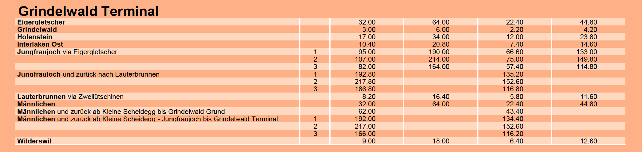
Below are some sample fares in Swiss francs, which at current exchange rates roughly equate 1 to 1 with the US dollar.  The trip to Eigengletscher from Grindelwald Terminal on the "3S" Eiger Express, a tri-cable gondola similar to the one proposed for Little Cottonwood, 64 Swiss francs/USD. 


The Eiger Express is about 6.5 km (4 miles) long and the ride takes about 15 minutes.  This is about half the length of the Little Cottonwood Gondola.  

You can get discounts.  We elected to buy a Swiss Half-Fare card for 120 Swiss francs, which gave us 50% off on all our our rail and cablecar travels in Switzerland.  Still, with that discount, the Eiger Express is 32 Swiss francs/USD round trip.  Alternatively, you can by a Jungfrau pass to cover much of the transport (190 for 3 days, 215 for 4, although the Jungfraujoch cog railway is additional).  

Switzerland is expensive and our days in the Jungfrau, while incredible, were surely the most expensive vacation days of our lives.  It's clearly an area for the well heeled, and I don't mean people who can hike a long ways.  

It makes me wonder about the future of the Wasatch.  If the Little Cottonwood Gondola is built, how much will it cost for individual users?  How accessible will the central Wasatch be for the broader community, not just those with financial means?   

Sunday, October 2, 2022

Blog Break

Taking some down time for a couple of weeks.  See everyone in mid October.  Maybe there will be hope for snow by then.  Until then, begin with a few slow breaths, in through your nose and out through your mouth.  Let your body relax.  Visualize snowy mountains.  Imagine skiing deep powder.  Do this several times a day.