Although we didn't hit the 80˚F US unit psych point for maximum temperatures, the last three days have been blisteringly hot.
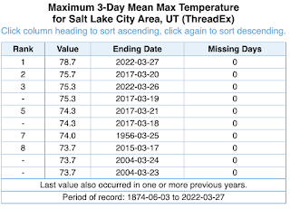
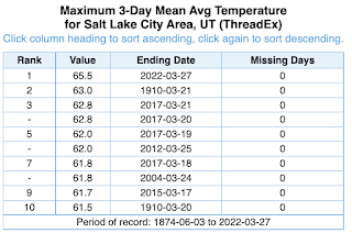
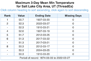
Salt Lake City area weather records begin in 1875 based on observations collected in downtown Salt Lake City prior to the 1920s and the Salt Lake City Airport thereafter. In terms of the mean maximum temperature and average temperature, the last 3 days were the warmest on record during 1-27 March.
 |
| Source: http://xmacis.rcc-acis.org/ |
 |
| Source: http://xmacis.rcc-acis.org/ |
 |
| Source: http://xmacis.rcc-acis.org/ |
Additionally, thin high clouds meant net longwave cooling was limited. I didn't bother skiing this weekend, but the Utah Avalanche Center notes this morning that most mountain locations have remained above freezing now for nearly 4 days. There are many reports of large wet avalanches, including naturals reported by snow safety teams overnight. Simply incredible. Below is one example.
 |
| Source: Utah Avalanche Center |
Not surprisingly, there has been significant snowpack loss in many areas. Below is the mean water equivalent of snowpack at SNOTEL sites in the Jordan basin. It has dropped from a peak of 14.2 inches on March 24 to 12.4 inches today.
.png) |
| Source: NRCS |
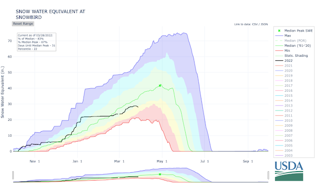
Even the Snowbird SNOTEL has declined about 0.8". I'm not sure if this is the result of sublimation, or an indication that the snowpack there has ripened and is already losing mass to melt, but it's never a good sign when upper-elevation SNOTEL sites are losing snow in late March.
 |
| Source: NRCS |
Nevertheless, the storm track returns this week. The pattern looks more typical of late March and early April than the late May/early June like weather we have had the past few days.

No comments:
Post a Comment