I took advantage of the cool weather and went out on an early morning bike ride to survey the scene. During the day, the scene is a bit less "volcanic", but smoke obscured a good portion of the southern half of the island. Note how the smoke is being transported southward, which reflects the northwesterly flow in the wake of a weak cold front that passed last night.
There's a sharp edge to the top of the smoke.
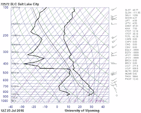
This is because there is an inversion in place over northern Utah behind the cold front. The morning sounding from the Salt Lake City airport shows the inversion extending from the surface, where it was about 20ºC to 800 mb, where it was about 23ºC.
We will see smoke mixing through a deeper layer later today as intense surface heating mixes out the inversion.
Looking south over the Salt Lake Valley showed the smoke covering the western Salt Lake Valley and then over the southern valley curving eastward to near the base of Lone Peak.

The central and eastern valley were clear, but that might also change later as our usual afternoon flows and turbulence favor transport and mixing through the valley.
At least it is a little cooler today for the firefighters, who have a difficult job ahead of them.


No comments:
Post a Comment