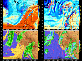
The latest GFS forecast below, valid for Sunday, Monday, and Tuesday afternoons, shows the high levels of moisture over the southwest today, with the weakening circulation of Ivo near the west coast of Baja. The remnants of Ivo then move across SoCal, the Sierra Nevada, and central Nevada.
 |
| Source: National Weather Service/weather.gov |
SHORT TERM...MODELS CONTINUE TO SHOW INCREASED MOISTURE ADVECTION OUT OF THE SOUTH TODAY THROUGH MONDAY WITH PWATS ON AVERAGE NEAR 1.5 INCHES BY MONDAY AFTERNOON...POTENTIALLY 2 INCHES ACROSS THE SOUTHERN EDGE OF THE FORECAST AREA. THE ONLY CHANGE TO THE FORECAST WAS TO DECREASE SHOWER/THUNDERSTORM CHANCES FOR THIS MORNING AS TIMING BEEN PUSHED BACK SLIGHTLY BUT OUTSIDE OF THAT THE INHERITED FORECAST WAS RIGHT ON TARGET. WITH A LARGE PERCENTAGE OF THE AREA STARTING OFF WITH MINIMAL CLOUD COVERAGE TODAY... THUNDERSTORMS MAY START SLIGHTLY SOONER AS WE REACH THE CONVECTIVE TEMPERATURES EARLIER. ONCE WE GET GOING...EXCELLENT DYNAMICS AND PLENTY OF MOISTURE WILL LEAD TO WIDESPREAD RAIN AND EMBEDDED THUNDERSTORMS TODAY. IN ADDITION TO THE INCREASED FLASH FLOOD THREAT...SOME STORMS MAY BE SEVERE AS WE SAW YESTERDAY WITH ENOUGH SHEAR ALOFT AND A WBZ TEMP NEAR 13KFT. MONDAY IS EXPECTED TO HAVE VERY SIMILAR CONDITIONS...OUTSIDE OF THE INFLUENCE OF ANY MCVS LEFT OVER FROM TODAYS ACTIVITY.The remnants of Ivo are now forecast by the GFS to eventually move into areas where monsoon thunderstorms are less common, including SoCal, the Sierra Nevada, and central Nevada.
All in all, a very exciting couple of days. Salt Lake is on the periphery of the most active area during this period, but a threat of thunderstorms remains. For our viewing pleasure, hopefully we will see some action that misses the burn scar areas.


No comments:
Post a Comment