
On the evening of Tuesday, 7 February (MST), strong, damaging winds struck the Jackson, WY area, snapping 17 steel power poles along the Moose-Wilson Road and, cutting off power to Teton Village and Jackson Hole Mountain Resort.
 |
| Source: Lower Valley Energy, via FirstTracksOnline. |
I thought we would take a look today at the events conspiring to wreak this havoc, although I confess I have more questions than answers at this time.
There were no wind observations provided to MesoWest in the immediate area of the damage. As such, for this preliminary write up, we are forced to rely on observations from the vicinity. The first is from the Jackson Airport, which reported sustianed winds reaching 40 mph and a peak gust just above 60 mph at about 0100 UTC (6 PM MST) before observations ceased. The wind direction during this period was S-SW.

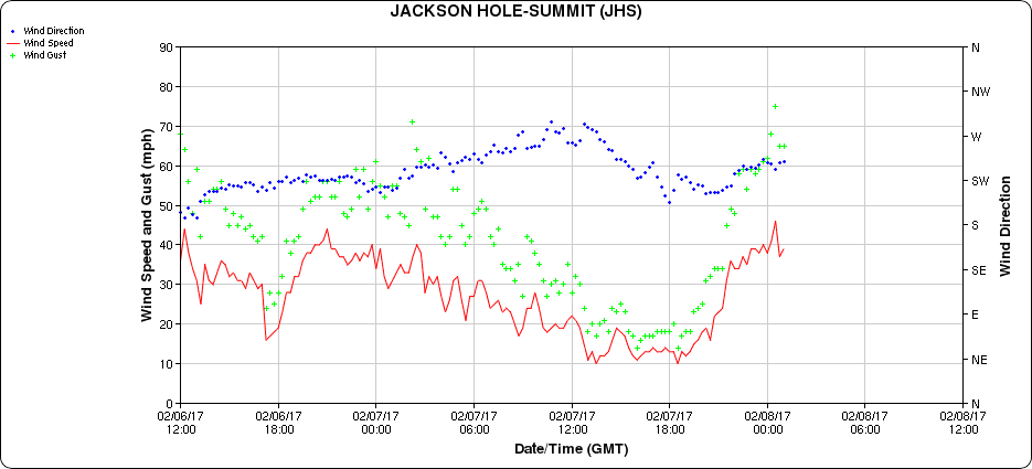
The other nearby site is at the summit of Jackson Hole Mountain Resort. The peak gust there was just above 75 mph at just after 0000 UTC (5 PM MST, note the differing time axis). Note that at this elevation, the sustained winds and the gusts during this period are not much stronger than those observed in the late afternoon and evening of the prior day. This contrasts with the Jackson Hole Airport where winds were much strong, indicating that something happened to cause anomalously strong valley winds.
At 1800 UTC 7 February, about 6 hours prior to the wind event, regional analyses from the GFS show a broad, low amplitude ridge across the western United States with the ridge axis centered over Nevada. An intense jet, with wind speeds of over 75 m/s (150 knots) extended across far northern California and Nevada. At 700 mb (10,000 ft above sea level, roughly crest height near Jackson Hole Mountain Resort), the flow was southwesterly and featured strong warm advection (i.e., winds transporting warm air into the region from the southwest). Basically, Jackson was in a warm-frontal zone.

The influence of this strong warm advection is clearly seen in the temperature time series from both the Jackson Airport and the summit of Jackson Hole Mountain Resort (note the differing time axes). At both sites, temperatures climbed prior to the wind event. The climb at the summit of Jackson Hole Mountain Resort (bottom image) was steady throughout the day, whereas at Jackson Hole Airport, it was more abrupt and occurred in the 2 hours prior to the wind storm. This often occurs with warm-frontal passages in which the cold air remains more persistent at low levels, especially deep mountain valleys. Note that the peak wind gusts may have occurred at the time of peak temperature, although the power outage precludes any chance to confirm that.


At 0000 UTC 8 February (5 PM MST 7 February), just prior to the wind event, an intense zonal (westerly) jet extended across northern California, Nevada, and Utah, just south of Jackson Hole. Temperatures at 700-mb had warmed significantly and Jackson was basically in the "ridge" of warmest air, with cold advection just upstream over Idaho. The surface trough, which is poorly analyzed at this resolution, was also very close to Jackson.


Analyses from the High Resolution Rapid Refresh (HRRR) show a surge of strong southwesterly flow up the eastern Snake River Plain just prior to the winds storm. Note in particular the "break-in" of strong southwesterly to westerly flow into the Jackson Hole region from 2300-0100 UTC below.
 |
| HRRR surface winds at 2300 UTC 7 February |
 |
| HRRR surface winds at 0000 UTC 8 February |
 |
| HRRR surface winds at 01 UTC 8 February |
 |
| Source: NCAR/College of DuPage |
 |
| Source: NCAR/College of DuPage |
So, given the limited data and the limited time I have to investigate this event, let me provide some early speculation. I suspect that an old occluded front and accompanying tongue of warm air passed across the Jackson area at the time of maximum winds. This feature was accompanied by a surge of strong SW-W flow. This is fairly consistent with my forecast that morning in which I warned of the potential for strong winds in the Wasatch Range (The Big Bad Wolf Is Coming to Town). What is less clear is whether or not the strongest winds were produced by some sort of terrain-driven circulation as that feature moved through, or potentially some sort of precipitation-induced feature if the convection over southeast Idaho extended into the Jackson area.
I am inclined to suspect the former, but only a careful investigation of this event in which we examine the high-resolution radar data, all surface wind observations, and perhaps do some numerical modeling, will allow us to determine if that hypothesis holds water. If you were in the Jackson area, please share your observations of the weather on that evening as they could prove useful.
No comments:
Post a Comment